
Karwendel
| Karwendel | |
|---|---|
 Overview map of the Karwendel |
|
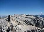
 The Gamsjoch group from the Sonnjoch west flank, on the left the Laliderer Wand with Kaltwasserkarspitze and Birkkarspitze, on the right behind the Falkengruppe |
|
| Highest peak | Birkkarspitze ( 2749 m above sea level ) |
| location | Tyrol , Austria / Bavaria , Germany |
| part of |
North Tyrolean Limestone Alps, Northern Eastern Alps |
| Classification according to |
AVE : 5 SOIUSA : 21.IV |
| Coordinates | 47 ° 25 ' N , 11 ° 26' E |
The Karwendel is a mountain group of the Northern Limestone Alps . The greater part (around 80%) is in Tyrol and the smaller part in Bavaria ; the border runs over the northern Karwendel range and through the Vorkarwendel . Four great mountain ranges stretch from west to east; there are also numerous side chains and groups and an extensive promontory to the north. The Karwendel takes its name from the old German family name Gerwentil , first mentioned in 1280, which was originally limited to the Karwendel valley near Scharnitz . Hermann von Barth extended the term to the entire area in the course of the development of the Alps in the 19th century.
Boundary and expansion
In the west the Karwendel is bounded by the Seefelder Sattel and part of the Isar valley , in the north by the Isarwinkel with the Sylvenstein reservoir and the lower Achental , in the east by the upper Achental with the Achensee and in the south by the Inntal . Important places are Seefeld in Tirol and Mittenwald in the west, Pertisau in the east and Innsbruck in the south . The mountain range extends from east to west of about 45 kilometers, from north to south of almost 30 kilometers.
structure
Hermann von Barth , the developer of the Karwendel, established the tradition of naming the chains after the valleys they border in the south: Karwendeltal , Hinterautal and Vomper Loch , Gleirschtal and Halltal , Inntal :
- Northern Karwendel range
- Hinterautal-Vomper chain (also Karwendel main chain)
- Gleirsch-Halltal chain
- Inntalkette (the southernmost Karwendel range, but from Innsbruck's point of view and in common parlance only called Nordkette )
Page groups are: Erlspitze Group , Soierngruppe , Vorkarwendel , Falcon , Gamsjoch- and Sonnjochgruppe and the Rough Knöll branch in the southeast of the Karwendel.

Classification according to SOIUSA
According to SOIUSA, the Karwendel is divided into two main groups and eight groups.
- Karwendel massif (A)
- Erlspitz Group (A.1)
- Internal chain (A.2)
- Gleirsch-Halltal chain (A.3)
- Hinterautal-Vomper chain ( A.4 )
- Karwendel chain (A.5)
- Falken-Gamsjoch-Sonnjoch massif ( A.6 )
- Falcon group (A.6.a)
- Gamsjoch group (A.6.b)
- Sonnjoch Group (A.6.c)
- Rauer-Knöll branch (A.7)
- Risser Mountains (B)
- Soierngruppe (B.8)
- Vorkarwendel (B.9)
- Montschein-Schafreuter chain ( B.9.a )
- Terror-Juffen chain ( B.9.b )
summit
There are 125 peaks in the Karwendel, which are over 2000 m above sea level. A. achieve. Here is an excerpt from the most important peaks:
|
|

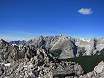
View from the zunlkopf on the northern Karwendel chain and the Hinterautal-Vomper chain
The Hinterautal-Vomper chain from the Pleisenspitze, the westernmost peak of the mountain range
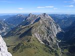
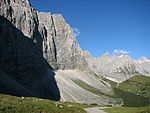
The falcon group from the south, on the right the Laliderer valley, on the left the Johannestal

The Praxmarerkar peaks in the Gleirsch-Halltal chain from the Nordkette
The northern Karwendel range east of the Bäralpl from the Pleisenspitze (Hinterautal-Vomper chain)


The Barthgrat between the Großer Katzenkopf and the Mittlerer Jägerkarspitze in the Gleirsch-Halltal chain, named after Hermann von Barth

Vogelkarspitze, Eastern Karwendelspitze, Grabenkar and Grabenkarspitze (far right) from the south

The middle part of the Hinterautal-Vomper chain from the eastern Ödkarspitze to the Lalidererspitze from the south

The Sonntagkar in the Gleirsch-Halltal chain from the Mandlspitze (Nordkette)
The Erlspitze is the highest peak of the Erlspitz group, the westernmost side group in the Karwendel


Neighboring mountain groups
The Karwendel borders the following other mountain groups in the Alps:
- Bavarian Prealps (in the north)
- Brandenberg Alps (in the east)
- Tux Alps (in the south)
- Stubai Alps (in the southwest)
- Mieminger Mountains (in the west)
- Wetterstein Mountains (in the west)
geology
The Karwendel consists of Wetterstein limestone and dolomite (the latter especially in the Erlspitz group). The four main chains are made up of mighty limestone banks that are inclined to the south due to the geological folding . The characteristic structure of the Karwendel can be seen particularly well in the Laliderer walls in the middle Hinterautal-Vomper chain. Constitute the broken edges of the vertical folding up to 1,000 meters high walls on the north side, south side from the gentler have glacial last Glacial wide Kare milled, by powerful ridges are separated.
Waters
The only, very small glacier in the Karwendel is located in the Hinterautal-Vomper chain north below the Eiskarlspitze in the Eiskarln .
With the exception of its outer sides, the Karwendel area is drained to the west and north. The Isar rises in the Hinterautal between the Hinterautal-Vomper chain and the Gleirsch-Halltal chain , with its tributaries Gleirschbach (left) and Karwendelbach (right) in the neighboring parallel valleys . The next two largest bodies of water in the Karwendel also flow into the Isar: the catchment area of the Rißbach , whose water is fed to the Niedernach power plant through the roughly seven-kilometer-long Rißbach tunnel and then fed into the Walchensee , mainly comprises the north side of the main massif and the Soiern group. To the northeast of it, the Dürrach drains the Vorkarwendel. The streams on the east side of the mountains flow into the Achensee (Pletzach with the Falzthurnbach and Oberaubach) and its natural course, the Isar inflow Seeache (Unteraubach, Dollmannsbach). The only noteworthy natural tributary of the Inn is the Vomper Bach in the southeast.
The small glacier in the Eiskarln below the Eiskarlspitze
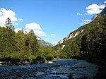
The Isar in the Hinterautal a few kilometers before Scharnitz
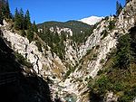
The Gleirschbach in the Gleirschklamm

The Johannesbach in the Johannestal, looking north to the Vorkarwendel
The Rissbach from the Kreuzbrücke towards Hinterriß


Flora and fauna
The common animal species of the Northern Limestone Alps can be found in the Karwendel; In particular, large packs of chamois can often be seen in the high Karen . In Sonnjochgebiet and on the north chain were ibex settled who have settled in well.
Settlements
The only permanent settlement within the Karwendel Mountains is the village of Hinterriß . Of the numerous alpine pastures , some are located in valleys, including the Eng as the most famous . But there are also high alpine pastures above the Inntal and the Vorkarwendel. In the eastern part of the Vorkarwendel, in the area of the Tiefenbachalm on the eastern slope of the Rether Horn ( 1656 m above sea level ), oil shale is mined, but only for cosmetics production and for the production of the so-called Tyrolean stone oil and therefore in relatively small quantities.
natural reserve
Both the Tyrolean and the Bavarian part of the Karwendel are under nature protection. The Tyrolean part of the Karwendel Nature Park has a size of 727 km² and thus forms one of the largest nature reserves in the Eastern Alps. The directly adjacent Bavarian nature reserve Karwendel and Karwendel foothills measures a further 190 km². These protected areas are cross-border with Bavaria as Natura 2000 area (both according to Fauna-Flora-Habitat Directive / FFH and according to the Birds Directive ).
The area is particularly characterized by the large population of golden eagles , the high naturalness of the forest and the Isar wild river system . In the nature reserve, camping, making fires, disturbing wild animals and picking (parts of) plants are prohibited.
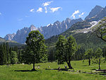
The Kleine Ahornboden in front of the Hinterautal-Vomper chain from the Grubenkarspitze to the Moserkarspitze

The Großer Ahornboden, looking north to the Kompar and Satteljoch
The Laliderer Wall from the Hohljoch

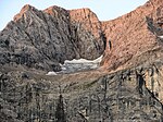
The Kaltwasserkarspitze from the Birkkarspitze

The small and large begging litter in the Gleirsch-Halltal chain


Karwendel Nature Park
The Karwendel Nature Park goes back to one of the oldest protected areas in the Eastern Alps (banned area from 1928). With an area of 727 km², it is also a Natura 2000 area as a whole (site code AT3309000). The nature park consists of 3 nature protection , 2 quiet and 6 landscape protection areas , and was declared a nature park in 2009 (LGBl. 26/2009):
- Karwendel nature reserve
- Martinswand nature reserve
- Questionsstein nature reserve
- Eppzirl quiet area
- Quiet area Achental -West
- Bärenkopf landscape protection area
- Falzthurntal –Gerntal landscape protection area
- Landscape protection area Großer Ahornboden
- Landscape protection area Martinswand - Solstein - Reither Spitze
- Nordkette protected landscape area
- Protected landscape area Vorberg
On the Tyrolean side, the Karwendel Nature Park sponsoring association has been entrusted with the management of the protected area since 2008 . Members of the association are the 15 Karwendel communities, five tourism associations, the Austrian Federal Forests, the German and Austrian Alpine Association, the Tyrolean Chamber of Agriculture and the State of Tyrol, on whose initiative the association was founded. The aim is to increase the involvement of the municipalities and landowners, and ultimately a higher level of acceptance for the protected area. The first major activity of the association was the 80th anniversary of the protected status with a comprehensive annual program and the geotag of biodiversity. In January 2009 the Karwendel program 2013 was adopted, in which the medium-term orientation in the areas of nature conservation, visitor offers and awareness-raising was laid down.
Karwendel and Karwendel foothills nature reserve
Regardless of this protection, there are also development measures that have provoked criticism (new alpine roads, oversized alpine buildings). In particular, the development of the source of the Isar in the Hinterautal in 2003 triggered a counter-initiative to protect the Karwendel ( now it's getting tight ). The heavy car traffic in the Eng is a thorn in the side of environmentalists. On the initiative of the Munich and Oberland sections of the German Alpine Club, the bus line from Lenggries to Eng ( Bergsteigerbus , RVO line 9569), which has since been discontinued , has been revived.

The western Vorkarwendel from the Sonnjoch

The Vorkarwendel from the Seebergspitze
The north chain from the Mandlspitze, view to the west
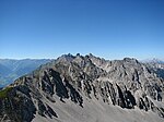
The western flank of the Rumerspitze
The Hafelekar station of the Nordkettenbahn


tourism
Development history
- 1843: Markus Vincent Lipold , Haller mountain and saltworks intern, climbed several peaks, including the Speckkarspitze and Pleisenspitze .
- Summer 1870: Hermann von Barth climbed 88 peaks alone (twelve of which were first ascents).
- 1888: Heinrich Schwaiger publishes the first Karwendel guide.
- October 6, 1901: Otto Melzer and Emil Spötl fall fatally when attempting to climb the north face of the Praxmarerkarspitze for the first time (a memorial on the way to the Sunntigerspitze reminds of this ).
- August 9, 1911: First ascent of the northern edge of the Laliderer Spitze ( Herzogkante ) by Otto , Christian and Paula Herzog
- March 4 to 10, 1969: Franz Sint, Paul Gürtler and Josl Knoll crossed the entire Hinterautal-Vomper chain for the first time
- January 28th to 30th, 1989: Heinz Zak traversed the entire Hinterautal-Vomper chain for the first time alone
There were also conflicts over the development of the Karwendel peaks. In 2004, markings and insurance were removed from the Dreizinkenspitze ( Rossloch ). The bolts attached to the edge of the duke were knocked over by strangers. In July 2005 the summit crosses of the Gamsjoch and the Kaltwasserkarspitze were broken from their anchorages and thrown down the mountain. In addition, there were re-developments of previously unmarked summit ascents ( Wörner , summit around the Pfeishütte), which aroused criticism.
Mountaineering in the Karwendel
Only a few peaks of the two mighty middle chains are accessible through good pathways. Most of the other peaks can be reached from the south without too much technical climbing difficulties, but the climbs through steep crags , pine and scree fields are partly pathless. The rock in the Karwendel is extremely fragile in many places.
In winter the peaks of the Vorkarwendel (e.g. Schafreuter , Juifen , Schönalmjoch ) are often climbed on skis , in spring and early summer also the great peaks of the Hinterautal-Vomper chain ( Birkkarspitze , Große Seekarspitze , Pleisenspitze ).
Mountain huts
There are 25 mountain huts in the Karwendel Mountains, 14 of which are Alpine Club huts of the German and Austrian Alpine Club . Eleven other privately operated huts also offer overnight accommodation. Most of the huts are only open in summer (from May / June to October), but often have winter rooms that are accessible outside the opening times . There are also various self-catering huts and bivouac boxes , which mainly serve as emergency accommodation. Here is a selection:
|
|
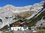
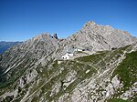
The Pfeishütte in front of the Sonntagkar, in the background the Gleirsch-Halltal chain

Bivouac box at the Laliderer tip

At the Pleisenhütte, view of the western Gleirsch-Halltal chain

The Plumsjochhütte in the Vorkarwendel

Bivouac box at the Breitgrieskarscharte


Via ferratas
In the Karwendel there are some secured summit ascents and via ferratas of all levels of difficulty:
- Mittenwalder Höhenweg from the western Karwendelspitze to the Tiroler Hütte (northern Karwendel range)
- Herzogensteig in the Soierngruppe
- Brendelsteig in the Hinterautal-Vomper chain
- Freiungen-Höhenweg and climb to the Reither Spitze in the Erlspitz Group
- Zirler via ferrata on the Erlspitze (Erlspitz group)
- Kaiser Max via ferrata through the Martinswand in the Nordkette (most difficult via ferrata in the Karwendel)
- Julius-Pock-Weg to the Vordere Brandjochspitze in the Nordkette
- Innsbruck via ferrata from the Hafelekar mountain station of the Nordkettenbahn to the Frau Hitt-Sattel (Nordkette)
- Via ferrata on the large and small Bettelwurf in the Gleirsch-Halltal chain
- Felix-Kuen-Steig on the Hundskopf in the Gleirsch-Halltal chain
- Via ferratas on the Lamsenspitze and the Hochnissl in the Hinterautal-Vomper chain
- Gjaidsteig in the northern Karwendel range
Long-distance and long-distance hiking trails
The Via Alpina , a cross-border long-distance hiking trail with five partial trails through the entire Alps, also runs through the Karwendel. The Via Alpina Red Trail runs through the Karwendel in three stages:
- Stage R41 leads from Schwaz in the Inn Valley to the Lamsenjochhütte.
- Stage R42 runs from the Lamsenjochhütte over the Hohljoch to the Falkenhütte.
- Stage R43 runs from the Falkenhütte via the Karwendelhaus to Scharnitz.
The dream path Munich-Venice also leads through the Karwendel. Although this is not an official long-distance hiking trail, the path that was first propagated in 1977 has now become more popular than many long-distance hiking trails created by hiking associations or public institutions.
- The 5th day of the dream path leads from Jachenau in the Bavarian Prealps to Hinterriß im Karwendel.
- The 6th day leads from Hinterriß over the Kleiner Ahornboden to the Karwendelhaus.
- The 7th day leads from the Karwendelhaus over the Schlauchkarsattel and the Hinterautal to the Hallerangerhaus. Of all the stages of the dream path between Munich and Venice, this is the most challenging, which is why it is also known as the royal stage.
- The 8th day leads from the Hallerangerhaus over the Lafatscher Joch to Hall in Tirol.
Traffic development
In the south, the Karwendel is bounded by the Inn Valley with the provincial capital Innsbruck and its agglomeration, which forms the most important traffic axis (motorway, train and airport) in Tyrol. Well-developed roads also open up the west ( Mittenwald , Scharnitz ), north ( Vorderriß , Fall ) and east sides ( Achensee , Pertisau , Achenkirch ) of the mountains.
Only one public road leads from the north ( Vorderriß ) via Hinterriß into the heart of the mountains to the Großer Ahornboden . This road is open all year round to Hinterriß, the further section into the Eng is toll road and only open from May until the onset of winter. From Pertisau am Achensee, the Falzthurntal and the Gerntal can be driven on a toll road from mid-May to the end of October. The valleys offer mountaineers good starting points for activities in the Sonnjoch group and the eastern Hinterautal-Vomper chain or in the Vorkarwendel.
The large east-west valleys are accessible by good, graveled forest roads, but are closed to motorized traffic (with the exception of residents, forestry companies and the Scharnitz taxi service) and are accordingly popular with mountain bikers. The Hinterautal, in which the Isar rises, is easily accessible by mountain bike over a length of 14 km from Scharnitz to the managed Kastenalm. The further route from the Kastenalm to the Hallerangerhaus, on the other hand, places very high demands on fitness and is only suitable for sufficiently experienced mountain bikers.
The Karwendel on the west and south-west side can be easily reached by public transport or by car. In particular, summit destinations in the Gleirsch-Halltal chain, the Hinterautal-Vomper chain and the northern Karwendel chain can be reached as day tours from Scharnitz or from Hinterriß in connection with a mountain bike tour through the valleys. The Mittenwaldbahn (also Karwendelbahn ) from Innsbruck to Garmisch connects the west side with the stations Mittenwald , Scharnitz , Gießenbach, Seefeld in Tirol and Hochzirl . The narrow-gauge Achenseebahn runs from Jenbach to Seespitz am Achensee station ; trains operate between May and the beginning of November. Year-round bus routes run from Tegernsee to Achensee to Pertisau and from Jenbach in the Inn Valley to Pertisau. From the middle of May to the beginning of November the so-called Bergsteigerbus (RVO line 9569) runs from Lenggries to the Eng.

New summit cross on the Hinteren Bachofenspitze

Sacred Heart Fire on the Seekar near Achenkirch
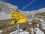
New signpost in the Sonntagkar

RVO bus in the Riss valley in front of the Schaufelspitze

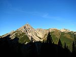
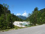
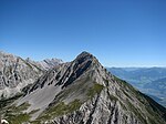
The northern Ahornboden from the Sonnjoch west flank


Mountain railways
Aerial cableway
From Mittenwald , an aerial cableway , the Karwendelbahn , leads up to the foot of the western Karwendelspitze , the starting point of the Mittenwald Höhenweg . In winter, you can ski down through the Dammkar . The route is not groomed, but secured against avalanches (blasting, possibly closure).
From the Innsbruck district of Hungerburg , the Nordkettenbahn runs in two sections over the Seegrube to the Hafelekarspitze .
To the west of Achenkirch is the Hochalmlifte Christlum winter sports area , which offers a number of chairlifts and drag lifts .
The Karwendel cable car , a gondola lift that opens up a hiking and winter sports area north of the Bärenkopf , leads from Pertisau to the Zwölferkopf .
Funiculars
There are two funiculars in the Karwendel .
- The Hungerburgbahn connects Innsbruck's city center via a curved route with the Hungerburg district on the mountainside north of the Inn, where the valley station of the Nordkettenbahn is located.
- A funicular takes you from Seefeld to the Rosshütte. From there, cable cars continue to the Seefelder Joch and the Härmelesgrat.
Literature and map
The Alpine Guidebook contains from the 14th edition of mountain and climbing tours that the II. Difficulty of UIAA scale exceed a few exceptions, no more. There is currently no work that describes the Karwendel comprehensively from a mountaineering and touristic point of view.
- Otto Stolz : History of the Karwendel region. In: Journal of the German and Austrian Alpine Association 66, 1935, pp. 39–71.
- Heinz Zak : Karwendel , Bruckmann , 1990, ISBN 3-7634-1022-8
- Wolfgang Ehn: Karwendel , Innsbruck 2002
- Walter Klier : Alpenvereinsführer Karwendel , 13th edition 1990, Bergverlag Rother , Munich, out of print
- Walter Klier: Alpenvereinsführer Karwendel alpin , 15th edition, 2005, Bergverlag Rother, Munich ISBN 3-7633-1121-1
- Bernd Eberle u. a .: Karwendel climbing guide , 3rd edition, 2006, Panico Verlag, ISBN 3-926807-54-7
Historical:
- August Rothpletz : The Karwendel Mountains , print from the magazine of the German and Austrian Alpine Association, Munich 1888 ( online, archive.org ).
Maps:
- Alpine Club Map 1: 25,000, pages 5/1, 5/2 and 5/3, Karwendel Mountains West, Middle and East

Web links
- karwendel.org - Official website of the Karwendel Nature Park Association. With information on nature conservation, tips for excursions and plenty of background information about the activities of the association
- steinmandl.de - General articles on the Karwendel Mountains and descriptions of selected tours
- tiroler-schutzgebiete.at - Tyrolean Protected Areas: Landscape protection areas in Tyrol
- jetz-werds-eng.de - Initiative against the sale of the Karwendel nature reserve
Individual evidence
- ↑ Alpine history website bergruf.de , accessed on February 2, 2017
- ^ Alpenvereinskarten 5/1, 5/2 and 5/3, Alpenvereinskartographie, Innsbruck 2005 and 2008
- ↑ a b Site code: AT3304000 Karwendel . Natura 2000 Data Form (PDF; 108 kB).
- ↑ Karwendel Alpine Park. on karwendel.org.
- ↑ Area for nature park with 72,741.16 ha, for Natura 2000 with 72,740.57 ha (source: tiris), or 73 km² (source site code: AT3309000 Tiroler Lech . Natura 2000 Data Form, pdf) indicated, area details and U. deviating depending on the scale of the recording
- ↑ Karwendel Alpine Park. In: tiroler-schutzgebiete.at. Office of the Tyrolean Provincial Government, Department of Environmental Protection, accessed on February 17, 2017 .
- ↑ Ordinance of the state government dated June 30, 2009 on the declaration of the Karwendel nature reserve, the Martinswand nature reserve, the questionsstein nature reserve, the Eppzirl quiet area, the Achental-West quiet area, the Bärenkopf nature reserve, the Falzthurntal-Gerntal nature reserve, the Großer Ahornboden nature reserve, the Landscape protection area Martinswand-Solstein-Reither Spitze, the landscape protection area Nordkette and the landscape protection area Vorberg zum Naturpark (Karwendel Nature Park) LGBl. 58/2009 26th items (pdf, tirol.gv.at)
- ↑ Bärenkopf landscape protection area. In: tiroler-schutzgebiete.at. Retrieved February 17, 2017 .
- ↑ Falzthurntal-Gerntal landscape protection area. In: tiroler-schutzgebiete.at. Retrieved February 17, 2017 .
- ↑ The Großer Ahornboden protected landscape area. In: tiroler-schutzgebiete.at. Retrieved February 17, 2017 .
- ↑ Martinswand - Solstein - Reither Spitze nature reserve. In: tiroler-schutzgebiete.at. Retrieved February 17, 2017 .
- ↑ Nordkette landscape protection area. In: tiroler-schutzgebiete.at. Retrieved February 17, 2017 .
- ↑ Vorberg landscape protection area. In: tiroler-schutzgebiete.at. Retrieved February 17, 2017 .
- ↑ Karwendel Program 2013 ( Memento from July 18, 2012 in the Internet Archive ) (PDF; 4 MB), accessed on September 20, 2012.
- ↑ Lit .: Zak 1990, pp. 83 ff.
- ↑ Bergsteigerbus: Timetable 2017 ( Memento of the original dated February 2, 2017 in the Internet Archive ) Info: The archive link was inserted automatically and has not yet been checked. Please check the original and archive link according to the instructions and then remove this notice. (PDF), accessed on February 2, 2017.

Allgäu Alps | Ammergau Alps | Bavarian Prealps | Berchtesgaden Alps | Brandenberg Alps | Bregenz Forest Mountains | Chiemgau Alps | Dachstein Mountains | Ennstal Alps | Gutenstein Alps | Hochschwabgruppe | Kaiser Mountains | Karwendel | Lechquellen Mountains | Lechtal Alps | Loferer and Leoganger Steinberge | Mürzsteg Alps | Upper Austrian Pre-Alps | Rax Schneeberg Group | Salzburg Slate Alps | Salzkammergut Mountains | Tennengebirge | Dead Mountains | Türnitz Alps | Wetterstein Mountains and Mieming Range | Vienna Woods | Ybbstal Alps