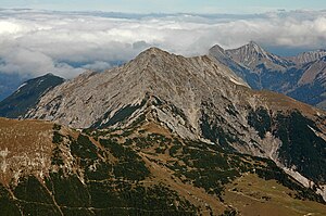
Montscheinspitze
| Montscheinspitze | ||
|---|---|---|
|
The south side of the Montscheinspitze with the Montscheinsenke |
||
| height | 2106 m above sea level A. | |
| location | Tyrol , Austria | |
| Mountains | Vorkarwendel , Karwendel | |
| Dominance | 3.5 km → Bettlerkarspitze | |
| Notch height | 457 m ↓ Plum saddle | |
| Coordinates | 47 ° 28 '0 " N , 11 ° 36' 49" E | |
|
|
||
| rock | Main dolomite and lias base limestone | |
| Age of the rock | Triad | |
| Normal way | Pertisau - Schleimssattel - Kelberg - Montscheinspitze | |
The Montscheinspitze (also Mondscheinspitze ) is 2106 m above sea level. A. high mountain in the Vorkarwendel in Tyrol . It is the highest and at the same time one of the most beautiful peaks of the Vorkarwendel. The summit can be reached from the east via Pertisau and the Gerntal . The southerly ascent starts from the Riss valley starting at the Hagelhütten ( 1077 m above sea level ) via the Plumsjochhütte , the Plumsjoch ( 1921 m above sea level ) and the Montscheinsenke to the summit. The ascent is not easy from either side and requires experienced and sure-footed mountaineers, as there are places in the I and II degrees of difficulty on the UIAA scale .
etymology
The term monticinu (Montschein) is of Romanesque origin and means small mountain pasture . So the name of the mountain has no relation to the term moonshine , although the name of the mountain has sometimes been corrupted as "moonshine peak" in literature.
Web links
Individual evidence
- ↑ Geological map of Bavaria with explanations (1: 500,000). Bavarian Geological State Office, 1998.
- ↑ George Hunter: Vordeutsche Almnamen and Alpine farming terms in Tirol (Part I). In: Der Alm- und Bergbauer, episode 6–7 / 01, pp. 23–26 (PDF file; 170 kB)


