Vorkarwendel
| Vorkarwendel | ||
|---|---|---|
|
The Grasbergkamm in the Vorkarwendel from the Sonnjoch |
||
| Highest peak | Montscheinspitze ( 2106 m above sea level ) | |
| location | Tyrol , Austria / Bavaria , Germany | |
| part of | Karwendels | |
|
|
||
| Coordinates | 47 ° 30 ' N , 11 ° 35' E | |
|
The Schafreuter from Schönalmjoch in winter |
||
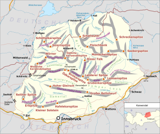
The Vorkarwendel is an extensive foothills of the Karwendel , a mountain group of the Northern Limestone Alps . It extends east and north of the Riss valley and north of the Sonnjoch group with peaks of over 2000 meters.
The peaks of the Vorkarwendel are popular tour destinations that can be climbed practically all year round. The Schafreuter is particularly popular because of its extensive view of the Hinterautal-Vomper chain and the Tölzer Hütte just below the summit . A high-altitude hike from the Tölzer Hütte over the Grasbergkamm with Fleischbank , Hölzelstaljoch , Grasberg and Kompar to the Plumsjochhütte offers views of the southern mountain groups of the Karwendel such as Falkengruppe , Gamsjochgruppe and Sonnjochgruppe .
A large part of the Vorkarwendel belongs to the Karwendel nature reserve .
King Ludwig II of Bavaria often spent time in this promontory and had a hunting lodge built there.
Important peaks (in order of altitude)
- Montscheinspitze ( 2106 m above sea level )
- Schafreuter (also Scharfreiter) ( 2102 m above sea level )
- Seebergspitze ( 2085 m above sea level )
- Seekarspitze ( 2053 m above sea level )
- Fleischbank ( 2026 m above sea level )
- Schreckenspitze ( 2022 m above sea level )
- Grasberg ( 2020 m above sea level )
- Hölzelstaljoch ( 2012 m above sea level )
- Kompar ( 2011 m above sea level )
- Juifen ( 1988 m above sea level )
- Schönalmjoch ( 1986 m above sea level )
- Delpsjoch ( 1945 m above sea level )
- Satteljoch ( 1935 m above sea level )
- Demeljoch ( 1924 m above sea level )
- Dürrnbergjoch ( 1835 m above sea level )
- Hochplatte ( 1813 m above sea level )


