Compar
| Compar | ||
|---|---|---|
|
The extra from the east |
||
| height | 2011 m above sea level A. | |
| location | Tyrol , Austria | |
| Mountains | Vorkarwendel , Karwendel | |
| Dominance | 2.3 km → Montscheinspitze | |
| Notch height | 214 m ↓ Montscheinsenke | |
| Coordinates | 47 ° 27 '19 " N , 11 ° 35' 5" E | |
|
|
||
| Normal way | easy mountain tour | |
|
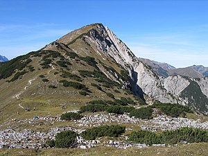
The Kompar (right in the picture) is part of the Grasberg ridge |
||
The Kompar is a 2011 m above sea level. A. high mountain in the Karwendel in Tyrol . From the summit there are extensive views of the Großer Ahornboden , the Gamsjochgruppe , the Falkengruppe and the Vorkarwendel .
The summit can be reached from the Hagelhütten ( 1077 m above sea level ) in the Rissal via the Hasentalalm or on a longer circular route via the Plumsalm ( 1423 m above sea level ), the Plumsjoch hut and the southern flank of the Satteljoch ( 1935 m above sea level). ) easy to reach. From the west an ascent is possible starting from the Kreuzbrücke ( 992 m above sea level ) over the Grasbergsattel ( 1540 m above sea level ) and from there via the ridge leading to the east. Furthermore, the Kompar is also used in the course of the transition from the Tölzer Hütte to the Plumsjochhütte via Fleischbank and Hölzelstaljoch .
The Kompar is a popular destination, especially in spring and autumn, when higher-lying destinations in the Karwendel can hardly be reached or only under difficult conditions due to the snow conditions.


