Demeljoch
| Demeljoch | ||
|---|---|---|
|
Demeljoch from the north (left Zotenjoch, middle Demeljoch, right Dürrnbergjoch) |
||
| height |
1923 m above sea level NHN 1924 u m. A. |
|
| location | Bavaria , Germany and Tyrol , Austria | |
| Mountains | Vorkarwendel , Karwendel | |
| Dominance | 2.8 km → Juifen | |
| Notch height | 419 m ↓ Rotwandalm Hochleger | |
| Coordinates | 47 ° 32 '47 " N , 11 ° 35' 15" E | |
|
|
||
| Normal way | Fall - Zotenalm Niederleger - Zotenalm Mittelleger - Zotenalm Hochleger - Demeljoch | |
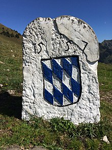
The Demeljoch is an elongated ridge in the Vorkarwendel southeast of Fall . The ridge consists of three peaks, the Dürrnbergjoch ( 1835 m above sea level ), the Demeljoch ( 1924 m above sea level ) and the Zotenjoch ( 1881 m above sea level ). The border between Bavaria and Tyrol and Germany and Austria runs from north to south over the summit of Demeljoch . Near the Demel-Hochlegers is the boundary stone no. 209 from 1557. The main summit can be reached from the village of Fall ( 773 m above sea level ) on the Sylvenstein reservoir as an easy mountain tour.
Web links
Commons : Demeljoch - collection of images, videos and audio files


