
Juifen
| Juifen | ||
|---|---|---|
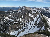
 The Juifen from the Torjoch |
||
| height | 1988 m above sea level A. | |
| location | Tyrol , Austria | |
| Mountains | Vorkarwendel , Karwendel | |
| Dominance | 5 km → Schreckenspitze | |
| Notch height | 334 m ↓ Groebner Neck | |
| Coordinates | 47 ° 32 '36 " N , 11 ° 37' 33" E | |
|
||
| rock | Lias base lime | |
| Age of the rock | law | |
 The Juifen from the southeast |
||

The Juifen is a 1988 m above sea level. A. high mountain in the Vorkarwendel in Tyrol . The summit can be easily reached from the Walchental east of the Sylvensteinsee and is also climbed in winter with skis or snowshoes .
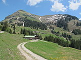
To the west below the summit is the Rotwandalm , which can be easily reached by mountain bike from the Bächental (junction behind the forester's house Aquila ( 919 m above sea level )). Alternatively, access is also possible from the Hagenwirt ( 826 m above sea level ) in the Achental.
A ridge over eight kilometers long connects to the south, the highest peak of which is the Schreckenspitze ( 2022 m above sea level ).
gallery
The summit of the Juifen from Demeljoch , in front of it the Zotenjoch
The Juifen from the southwest


Web links
Individual evidence
- ^ Bavarian Geological State Office, 1998, Geological map of Bavaria with explanations 1: 500,000