
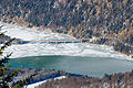
Sylvenstein Speicher
| Sylvenstein Speicher | |||||||||||
|---|---|---|---|---|---|---|---|---|---|---|---|
.jpg) |
|||||||||||
|
|||||||||||
|
|||||||||||
| Coordinates | 47 ° 34 '40 " N , 11 ° 32' 28" E | ||||||||||
| Data on the structure | |||||||||||
| Construction time: | 1954-1959 Retrofitting: |
||||||||||
| Height of the barrier structure : | 44 m | ||||||||||
| Building volume: | 1.03 million m³ | ||||||||||
| Crown length: | 180 m | ||||||||||
| Crown width: | 15 m | ||||||||||
| Power plant output: | 6.4 MW | ||||||||||
| Data on the reservoir | |||||||||||
| Altitude (at congestion destination ) | Max. 767 m | ||||||||||
| Water surface | 3.92 km² | ||||||||||
| Reservoir length | 7 km | ||||||||||
| Reservoir width | 2 km | ||||||||||
| Storage space | 124.3 million m³ | ||||||||||
| Catchment area | 1138 km² | ||||||||||


The Sylvenstein reservoir , also called Sylvensteinstausee or simply Sylvensteinsee , is a reservoir in the Isarwinkel in the municipality of Lenggries , on the road from Bad Tölz to Achensee ( federal road 307 ), about 12 km south of the center of Lenggries. It was built between 1954 and 1959 for flood protection in the Isar valley . A sufficient flow of water in the Isar has been ensured during dry periods since 1990; for ecological reasons, a residual inflow of at least 4 m³ / s is guaranteed at the Krüner weir .
The maximum storage volume is 124.3 million m³ of water. Two hydropower plants on the dam are used to generate electricity. From 1994 to 2001 the dam was raised by 3 m to improve flood protection. The elevation of the dam and the second flood relief tunnel with the temple-like inlet structure and with an output of up to 400 m³ / s already proved themselves at the Whitsun flood in 1999 . When the Alpine floods were even stronger in 2005 , the sluice had to be opened on the afternoon of August 23, 2005, as the Sylvenstein reservoir had reached the maximum level.
The reservoir was named after the Sylvenstein, a rocky ridge that delimits a natural bottleneck 113 m wide to the east in the upper Isar valley. The western limit is the rocky Hennenköpfl. The Sylvensteinsee is also a destination and a recreational area. The former village of Fall lies sunk in the lake. It was demolished before the flooding and rebuilt a few dozen meters higher on the road to Vorderriß .
history
Reasons to build
Since 1924, a large part of the Isar at the Krüner Wehr has been diverted to the Walchensee for the Walchensee power plant that was put into operation . From 1949 the Rißbach , which formerly flowed into the Isar, is also diverted into the Walchensee through the Rißbach tunnel. Originally , the Achensee also drained over the Ache into the Isar. With the construction of the Achensee hydropower plant in Jenbach in 1927, the Isar was also deprived of this water inflow (and also the Dürrach, which is diverted into the Achensee), since the water of the Achensee has since then primarily been via the power plant in the Inn, which is 380 m below got. The upper part of the Isar became more and more of a river corpse, especially in dry seasons the water level was low; the city of Bad Tölz suffered from a lack of water. Therefore, the then very controversial construction of the Sylvenstein reservoir was finally started in order to achieve a more constant water level of the Isar. The additionally guaranteed flood protection, however, was only a secondary goal, but it has particularly proven itself during the floods in 1999 and 2005. Originally the lake was planned to be much larger and should extend to the front rift.
Modernization measures
Extensive modernization measures were carried out from 1994 to 2001. A dam control system was installed, a second flood relief system was built and the dam was raised to enlarge the flood protection area. A second power plant was also built. The new power plant has a compact axial turbine with an output of 3.8 MW and a standard energy capacity of 20,000 MWh per year.
From 2011 to 2016, an additional cut-off wall and an improved collection and monitoring system for seepage were installed .
Buildings
Hydropower plants
Power plant I
(since 1959, rebuilt in October 2004)
| Francis spiral turbine , Kössler company | 2.6 MW |
| Drop height: | 13-37 m |
| Flow rate: | Max. 11 m³ / s |
| Speed : | 428 rpm |
Power plant II
(since 2000)
| Compact axial turbine | 3.8 MW |
| Drop height: | 13-37 m |
| Flow rate: | Max. 15 m³ / s |
| Standard work capacity | 20 million kWh / year |
dam
The dam is 44 m high and its crest is 180 m long. In addition to the Isar, the dam also dams its tributaries Dürrach (southern arm) and Walchen (eastern arm). The Isar and Dürrach carry large amounts of sediment and sedimentary rocks with them, which will fill the reservoir in the coming decades. For the wild Isar river, “taming” means a loss of habitat for specialized animal and plant species on the gravel banks that are repeatedly relocated by the water - especially during floods . This anthropogenic change in the river landscape ecosystem is particularly striking in the Pupplinger Au near Wolfratshausen , where the alluvial forest has expanded considerably over the past 50 years on previously open gravel areas.
The dam is a dam made of gravel , rubble and sand with a central sealing core made of earth concrete (75% gravel, 8% fine sand , 17% silt and a small amount of bentonite ). It stands on an erosion channel up to 100 m deep , filled with rubble by the Isar over the years, through which groundwater flowed. Before construction of the actual dam could begin, this channel had to be grouted with a clay / cement / water glass suspension and a 5,000 m² sealing skirt had to be inserted to seal the valley below the visible dam.
Faller Klamm Bridge
The multi-web girder bridge was built in 1957 and is 329 meters long.
| Faller Klamm Bridge | |
|---|---|
 |
|
| use | Road bridge ( Bundesstrasse 307 ) |
| Convicted | Sylvenstein reservoir |
| place | Case (Lenggries) |
| construction | Multi-leg girder bridge |
| overall length | 329 m |
| completion | 1957 |
| opening | 1957 |
Nature and landscape protection
The Sylvensteinsee is part of the landscape protection area "LSG Sylvensteinsee and upper Isar valley in the communities of Lenggries and Jachenau" (LSG-00341.01), which was placed under protection in 1983. Parts of the lake have been part of the "Upper Isar Valley" FFH area since 2004 .
Others
Some film scenes were filmed at Sylvensteinspeicher, including scenes from the film There is still something going on and from the film Jesus loves me (both with Florian David Fitz ) and The Story of Brandner Kaspar with Michael Bully Herbig .
literature
- Anton Böhm: Fall - The sunken village. Self-published, Rottach-Egern 2003.
- The upper Isar - a journey through time: Old Fall - New Fall - Sylvenstein reservoir. Eder-Verlag, 2001, ISBN 3-9805665-2-8 .
- Impressions at Lake Sylvenstein. Claus Eder, 2004, ISBN 3-9805665-7-9 .
- Geology of the Isar valley area in the area of the Rissbach tunnel and the planned Sylvenstein reservoir. Paul Schmidt, 1950.
- Memorandum on the construction of a storage facility in the upper Isar valley. Supreme building authority in the Bavarian State Ministry of the Interior, 1949.
- The new construction of the power plant I on Sylvensteinsee (= members' newsletter . 2/2005, German Association for Water Management, State Association of Bavaria).
- Reservoirs in Bavaria. Water Management in Bavaria - Issue 31, Bavarian State Ministry for Regional Development and Environmental Issues, Bartels & Wernitz, Munich 1997, ISBN 3-910088-46-5 (pp. 34–37)
- Wolfgang Wirth: Over bridges. Gerhart Klammert - Ed., Bayerischer Bauindustrieverband, Munich 1990 (pp. 50–51 Faller Klammbrücke - 400m long eight-span composite bridge. )
Picture gallery


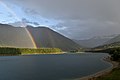
The Isar flows into the Sylvenstein reservoir.

The Sylvenstein reservoir
Bridge over the Sylvenstein reservoir

Alt-Fall on December 7th, 2015

Alt-Fall on December 26th, 2015

Sylvensteinspeicher on December 26, 2015

High water marks on the bridge over the Sylvenstein reservoir

Sylvensteinspeicher December 2015

Memorial plaque for workers who have had an accident
A segment of the old drum gate

View to the eastern part of the lake
View from Faller-Klamm-Bridge to the south


_Sylvensteinspeicher.jpg)
_Drumgate.jpg)


Web links
- Sylvenstein (I / II) Bavarian state power plants
- Water Management Office Weilheim: Sylvenstein Reservoir (further links at the end of the article)
Footnotes
- ↑ a b landeskraftwerke.bayern
- ↑ a b c Sylvenstein dam ( memento from July 18, 2011 in the Internet Archive ) wwa-wm.bayern.de, accessed on December 13, 2010.
- ↑ Lenggries - large construction site Sylvensteinspeicher. In: sueddeutsche.de , March 14, 2011
- ↑ http://www.wwa-wm.bayern.de/fluesse_seen/gewaesserportraits/sylvensteinspeicher/doc/2009_broschuere_sylvenstein_klein.pdf , p. 84
- ↑ Sylvensteinsee and upper Isar valley. In: protected planet
- ↑ 8034371 Upper Isar Valley. (FFH area) Profiles of the Natura 2000 areas. Published by the Federal Agency for Nature Conservation . Retrieved March 18, 2017.
- ↑ bayern.by ( Memento from July 29, 2017 in the Internet Archive )

Upper Isar: Krün | Sylvenstein | Stain | Bad Toelz | Mühltal (Mühltalkanal)
Walchensee / Loisach: Obernach | Niedernach | Walchensee | Schönmühl | Beuerberg | Eurasburg | Wolfratshausen
Isar-Werkkanal: Höllriegelskreuth | Pullach | Isarwerk 1 | Isarwerk 2 | Isarwerk 3 | Stadtbachstufe
Auer Mühlbach: Kraemer's art mill | Baker's mill | Muffatwerk | Maxwerk
Middle Isar: Prater | Tivoli (Eisbach) | Oberföhring | Ludwigswehr | Gerlmühle | Maxwehr
Middle Isar Canal: Ismaning | New insing | Church up | Eitting | Pfrombach | Uppenborn 1 + 2
Lower Isar: Altheim | Niederaichbach | Gummering | Dingolfing | Gottfrieding | Landau | Ettling | Softly