
Walchensee
| Walchensee | ||
|---|---|---|

|
||
| Geographical location | Bad Tölz-Wolfratshausen district | |
| Tributaries | Obernach Canal , Altlach, Rißbachstollen , Silbertsgraben, Deiningbach, Hammersbach, Sachsenbach | |
| Drain | Walchensee power plant (tunnel), Jachen (east) | |
| Islands | Sassau , formerly Katzeninsel | |
| Location close to the shore | Kochel am See | |
| Data | ||
| Coordinates | 47 ° 35 '38 " N , 11 ° 20' 46" E | |
|
||
| Altitude above sea level | 800.8 m above sea level NN | |
| surface | 16.27 km² | |
| length | 6.69 km | |
| width | 4.925 km | |
| volume | 1,299.7 km³ | |
| scope | 27 km | |
| Maximum depth | 190 m | |
| Middle deep | 80.8 m | |
| PH value | 8.1 | |
| Catchment area | 783 km² | |
|
particularities |
Drain in a power plant. |
|

|
||
| Map: Walchensee and Kochelsee | ||


The Walchensee is one of the deepest (maximum depth: 190 m) and at the same time one of the largest (16.40 km²) alpine lakes in Germany . It is located 75 km south of Munich in the Bavarian Prealps , at 800 m above sea level and with its entire area including the island of Sassau in the municipality of Kochel am See . In the east and south its bank borders on the municipality of Jachenau . The landowner of the lake and island area is the Bavarian State (administered by the Bavarian State Forests in contrast to most of the other larger lakes in Bavaria, which are subject to the administration of the state palaces, gardens and lakes ).
Originally a natural lake, it has been used since 1924 as a water reservoir for the Walchensee power plant located 200 m below at Kochelsee .
etymology
The part of the name Walchen is considered ambiguous. It can refer to the "Walchen" or " Welschen ", as in older German the neighboring Romance population of the Alps or south of the Alps was called. This did not necessarily require a resident Romanesque population (which the other place names of the area speak against), but could only be an indication that the place is on the way towards Welschland. This is supported by the fact that the lake was referred to as Italico dicto (leading to Italy) on maps from the 16th century , because a travel route led through the Walchensee valley via Mittenwald and Innsbruck to Italy .
“Walch” can also mean “moist, lukewarm, mild” or stand for “rolling, squeezing”. Another interpretation that is untenable for linguistic reasons because of the internal "ch" is based on the Latin Lacus vallensis , which means something like "a lake in the valley".
On the linguistic point of view, compare the articles Walensee , Walchsee and Wallersee .
geography
Emergence
The Walchensee fills a tectonically conditioned depression, which is part of the Bavarian Synkline and consists of the rocks of the upper, Alpine Triassic (main dolomite, plate limestone, Kössen layers). The lake owes its unusual depth of over 190 m to this tectonic formation. The north-western cliff clearly shows the very steep layers of rock facing the lake. The emergence of mountain-building forces leads to the conclusion that the Walchensee is one of the oldest lakes in Germany. During the ice ages , the morphology of the area and thus also of the Walchensee was shaped several times by the glaciers of the Isar-Loisach glacier .
structure
According to the geographer Alois Geistbeck (1885), the Walchensee was divided from south to north into three basins or parts of the lake of different sizes:
- Obersee or Altlacher See
- Weitsee (also called deep sea)
- Urfeldersee (Untersee, today the name Urfelder Bucht is more common)
The boundary between the shallow Urfelder bay and the deep Weitsee forms of 15 to 180 meters depth steep Dessel wall or the north and above it lies, described by Geistbeck schmalrückige rock bank whose up to 10 m below the water level up urgent e place of the Urfelder Berg is ( 47 ° 36 ′ 34.4 ″ N , 11 ° 20 ′ 53.2 ″ E ) and which begins in the east on the Desseleck .
The border between the Weitsee and the Obersee (Altlacher See) is formed by the island of Sassau in the east and its extension to the east bank of Lake Am Steineck, 210 meters away . The water depth in between is only 15 to 23 meters, which is why the island has already been compared to a peninsula. Sassau and the Steineck form the southern boundary of the Breite Bucht , which extends in the north to the small Buchenort peninsula .
In addition to the large Zwergern peninsula, there are also several small peninsulas, including Hirschhörnl (between the Saxony Bay in the north and the Stillen Winkel in the south) and Buchenort (bounded in the north by the Stillen Winkel and in the south by the Breite Bucht) on the east bank and Breitort (between Niedernacher Bucht in the east and Altlacher Tal in the west) on the south bank. In the Obernacher Winkel near the south bank there used to be the very small Katzeninsel, which is now connected to the mainland and only separated from it at maximum water levels.
The lowest point of the Walchensee is at 47 ° 36 '6.4 " N , 11 ° 20" 45.9 " E a good kilometer east-southeast of the eponymous rock spur Kirchel above the Uferstraße ( B 11 ) at the northern entrance of the Kirchelwand tunnel and above the steep one north-western cliff. The bottom of the lake falls at its steepest from the lakeshore at Kirchel, where it also descends 180 meters over a horizontal distance of 180 meters, which corresponds to a slope of 45 °. The hover within the depth line of 190 meters is known as Kirchel Grund . It has an area of almost one square kilometer and is level with the table, with fluctuations of only two meters.
![]() Map with all coordinates: OSM | WikiMap
Map with all coordinates: OSM | WikiMap
Location and neighboring villages
Around 27 km of banks surround the mountain lake, which has an average water volume of 1.3 km³. The Jachen , as a natural outflow of the lake, drains east through the Jachenau valley to the Isar . The largest natural tributary is the Obernach, which flows into the lake in the southwest. Together with the artificial inflow (see chapter Walchensee power plant ), this opens up a catchment area of around 780 km².
The lake is at an altitude of 802 m above sea level. NN and is framed by wooded mountains. So in the northwest of the Herzogstand - Heimgarten group (1,731 m and 1,790 m), then west of the lake is the valley of the Eschenlaine , on the south side of which the Simetsberg (1,836 m) connects as the first foothill of the Estergebirge . In the south of the lake, the long ridge of the Altlachberg with the Altlacher Hochkopf (1,326 m) as the highest point separates the Walchensee from the Isar valley. The Jachenau, a long valley that leads towards Lenggries , begins on the eastern bank . In the northeast, the Jochberg (1,565 m) closes the basin. Between Jochberg and Herzogstand lies the Kesselberg pass , which separates the Walchensee from the Kochelsee 200 meters below .
The small climatic health resort of Walchensee with approx. 600 inhabitants is located directly on the west bank . Like the other even smaller villages Urfeld (at the northern tip), Zwergern (west bank) and the houses of Einsiedl (in the extreme southwest) on the orographic left bank of the Obernach, Walchensee belongs to the municipality of Kochel am See. The houses on the right bank of the Obernach in Einsiedl and Altlach on the south bank, Sachbach on the east bank and Niedernach in the extreme south-east, however, belong to the municipality of Jachenau. Between the towns of Walchensee and Einsiedl the 140 projects hectares large peninsula Zwergern with the eponymous hamlet two kilometers into the lake.
The surface of the lake has approximately the shape of a triangle pointing northwards with a base on the south bank from Einsiedl to Niedernach with a side length of 6.9 km and a height of 4.9 km from Breitort to Urfeld.
climate
Due to its location in the valley basin, the lake is largely protected from northern and eastern wind currents. The relatively low mountain range, which begins directly on the south bank, allows optimal solar radiation, so that the climate is generally milder than would be expected in the mountains. During the summer months, when the weather is sunny, pronounced thermals develop over the heated southern slopes of the Herzogstand and the Jochberg . The stable thermal winds usually blow in a south-westerly direction. If the moist air masses of the Walchensee, which is transported upwards, combine with that of the Kochelsee in the north due to a light, prevailing main wind from the northeast, particularly violent thunderstorms can arise.
In hairdryer contrast, blowing a warm fall wind from the south; the accompanying dry air ensures a very good view.
history
The local population probably felt closely connected to the lake since prehistoric times. For example, until the 18th century it was customary to sink consecrated gold coins into the deepest part of the lake.
The abundance of fish in the lake meant that the monasteries Benediktbeuern and Schlehdorf made their first claims to ownership as early as 740 AD. The lake was first mentioned in a document in 763, but only as a geographical definition without a name. In the 11th century evidence of the name “Walhense”, 1441 “Wallersee”, 1698 “Walchensee”. The name is explained with "lake where the Romans lived". The Romanesque Walchen continued to live in southern Bavaria in the 5th century after the Roman occupation left . Until the secularization of 1803 this was owned by the two monasteries, with the Benediktbeuern monastery having the greater rights.
Around 1130, Abbot Konrad von Benediktbeuern, after consultation with Bishop Heinrich I von Freising, who was responsible for the Schlehdorf Monastery, which was part of the Walchensee, cleared the west bank of the lake and started settlement there with a first house for fishermen. The settlement of the Zwergern peninsula by Schlehdorf Monastery began around 1160.
Around 1900 the idea for the Walchensee power plant was born in Munich , which uses the gradient between Walchensee and Kochelsee, which is almost 200 meters below, to generate electricity. To this end, diving attempts were carried out as early as 1903 to explore the lake bedrock. The driving force was Oskar von Miller , who also founded the Deutsches Museum in 1903. The water police approval process dragged on until 1918. Construction work began immediately after the First World War . On January 24, 1924, Walchensee water drove a turbine on the shores of the Kochelsee for the first time.
During the Second World War , at least two planes tried to ditch the lake; both then sank.

On April 24, 1945, the Wehrmacht and officials of the Reichsbank brought at least part of the last reserves of the Deutsche Reichsbank to Einsiedl, a small settlement on the south-west bank. The property was then buried in an unknown location on the Steinriegel (above today's Obernachkraftwerk). There were 365 bags with two gold bars each , 9 envelopes with the documents on the gold, 4 boxes with gold, 2 bags with gold coins, 6 boxes with Danish coins and 94 bags with other foreign currencies. The foreign currency was mainly US dollars and Swiss francs . On June 6, 1945 the property was handed over to the Allies . However, 100 gold bars and all Swiss francs and dollar bills were missing. There may also be other depots where valuables such as other foreign currency and / or jewels were hidden. To this day there is speculation about their existence and their exact location.
The Walchensee became a popular destination for day trippers from Munich and other Upper Bavarian cities as well as holidaymakers from the 1930s at the latest. Today the local population lives primarily from tourism.
Until December 31, 1969, the Walchensee belonged to the community-free area Kochel, which otherwise consisted of the western part of the extensive former forest holdings of the Benediktbeuern monastery (with an area of 53.82 km² including the Walchensee), and was with this on the following day in the Municipality of Kochel am See incorporated. On the same day, the east bank with the community-free area of Jachenau was incorporated into the community of Jachenau. Previously set on the eastern shore only exclave Sachenbach to the municipality Jachenau.
biology
ecology

The clear water with an average visibility of 8 to 10 m owes its turquoise-green color to the relatively high proportion of calcium carbonate . Probably due to the motorboat ban the water meets the Walchensee the water quality class I (= unloaded). As is typical for a mountain lake, the water temperatures are relatively low. They move between 17 and 22 ° C in summer and around 10 to 16 ° C in spring / autumn. The nutrient load of the already oligotrophic (nutrient-poor) Walchensee has decreased further since the mid-1980s due to the improvement in wastewater treatment between Seefeld and Wallgau.
The Walchensee including the shoreline is a protected landscape area . Of the total length of the south bank of 7 km, approx. 2.5 km are for recreational purposes, e.g. B. as a beach, usable. The rest of the bank consists largely of steep banks. With a few exceptions in the west, the lakeshore itself is not built on.
The island of Sassau (2.9 ha) is under nature protection , i. H. Entering the island is prohibited all year round. The island is 367 m long and up to 93 m wide in the west (only half as wide in the east). It rises up to 12 m above the water level.
fauna and Flora
New fish species were naturalized in Walchensee over 500 years ago. In 1480 whitefish from the nearby Kochelsee were used and a little later also char from the Tegernsee . The lake can be divided into a shore zone and a ground and open water zone. All fish species are listed according to these habitats in the adjacent table.
| Riparian zone | Ground zone | Open water zone |
|---|---|---|
| eel | Great deer | Pikeperch |
| chub | Small deer | Lake trout |
| Bream | burbot | Arctic char |
| minnow | Pearl fish | Rainbow trout |
| Bream | nose | Mairenke |
| hazel | Barbel | Whitefish |
| pike | perch | |
| Bleak | Ruff | |
| Nerfling | Crucian carp | |
| roach | loach | |
| Rudd | Koppe | |
| Differed | ||
| tench | ||
| Mirror carp | ||
| catfish | ||
| Counted |
More than 50% of the fish species living there are threatened or at least endangered in Bavaria. B. the catfish or the pearl fish. The pond clam is also on the red list of endangered plants and animals.

In 2003, the Upper Bavaria district started a project to reintroduce the noble crayfish (Astacus astacus). For this purpose, 2,000 crabs were caught in the Eibsee and released in the Walchensee.
The lakeshore and the island of Sassau offer excellent breeding opportunities for many bird species and a safe winter or migration roost for migratory birds . Besides Rothals- and black-necked grebe and mallard and coot also come here Goosander and ice diver before.
In some bays near the bank zones, flooding water crowfoot and spiky thousand leaf grow directly under the water surface . Diatoms and green algae , on the other hand, occur as plant plankton together with animal plankton ( water fleas , hoppers ) in practically all areas of the lake. The native reeds and pond rushes also grow in the bank zone . Water lilies and pond roses not only offer grass snakes reliable protection.
tourism
A cable car ( Herzogstandbahn ) runs up to the Fahrenbergkopf from spring to autumn until just below the summit . From there you can get past the Herzogstandhaus in 30 to 45 minutes walk to the summit of the Duke matter .

Comparable to the other large lakes, e.g. B. the Tegernsee, the Walchensee also plays a major role for tourism in the region. The clear view underwater with a visibility of up to 40 meters and a whole series of car, boat and even airplane wrecks is particularly interesting for divers . In addition to the usual activities such as swimming or walking, those looking for relaxation can also hike in the surrounding mountains or explore the mountains on touring skis in the winter months .
The wind also plays a major role in tourism at Walchensee. Due to its location, the Walchensee is a thermal area and offers excellent conditions for windsurfers , kite surfers and sailors to practice the respective sport. When the weather is nice, the thermal wind usually arises in Urfeld around 12 noon and then slowly moves across the entire lake. On normal summer days the wind reaches a strength of 3 to 4. The best wind days are those after a cold front has passed through, when the air is thermally most active. The basic wind direction, which should blow from north to east, has an influence on good wind at Walchensee. If the wind comes from the south, the chances of good wind are rather bad. The temperature difference between day and night also plays an important role, with 5 ° C at night and 20 ° C during the day being better than 15 ° C at night and 30 ° C during the day.
When there is fog in the foothills of the Alps in autumn and spring but the sun shines in the mountains, a special situation occasionally arises. In the course of such a day it can happen that the base of the fog rises and it pulls over the Kesselberg and Walchensee. The then quite cold wind with strength 6 to 7 can blow over the Walchensee.
At Walchensee there is not only wind from northeastern directions. If there is a foehn in the Alps , it can also blow at Walchensee. The foehn comes from the south and is usually very gusty even at Lake Walchensee. The wind strength at foehn is very different and varies between 1 and 10.
Walchensee power plant


As early as 1924, the storage power plant Walchensee on the south bank of the Kochelsee was put into operation by Bayernwerk . Since then, six pipes have been conveying the water from the Walchensee to the turbines of the hydropower plant, which are about 200 meters below . In order to increase the availability of water for the power plant, the Rißbach from the Karwendel and part of the water from the Isar are fed to the lake through a 7 km long tunnel . Overall, the Walchensee has an average volume of 1.3 billion m³. Two smaller hydropower plants were also built directly on Lake Walchensee: at the end of the tunnel near Niedernach in the south-east and the Obernach power plant in the south-west of the lake.
Only during the winter months is water taken from the lake on a large scale in order not to impair tourism during the high season. In the winters of 1963 and 1980 the lake was completely frozen over.
- Maximum traffic jam: 802 m above sea level NN
- Normal traffic jam: 801.5 m above sea level NN
- Minimum traffic jam: 795 m above sea level NN
particularities

Wrecks
There are several wrecks on the lake bed, including those of three aircraft. A Messerschmitt Bf 109 and a British Avro Lancaster bomber originate from the Second World War . The wreckage of another aircraft is the remains of an Aero Commander 680W . The twin-engine high-wing aircraft with the registration D-IMON crashed into the lake on December 27, 1978 after the tail unit had broken off. The aircraft lay in shallow water and was recovered together with the crew immediately after the crash.
The wrecks of a VW Beetle and a Ford , which lie near the shore, are popular with divers as an exploration destination.
The lake as a filming location

Due to its attractive appearance, the Walchensee has been used as a filming location several times, especially for films with historical themes. For example, the series Tales of the Vikings with Christopher Lee was filmed there in 1959 . A year later, the lake was the setting in the drama Till the Money Divorce You ... with Luise Ullrich and Gert Fröbe . The same film producer Artur Brauner had shot some scenes for the film Liebe, Tanz und 1000 Schlager with Caterina Valente , Peter Alexander and Rudolf Platte at the same location as early as 1955 . In 2008 Michael Herbig shot the real-life version of Wickie and the Strong Men in the Saxony Bay . For this purpose, the Viking village Flake and other equipment were built there. After a thorough search across Europe, this location was chosen. After the end of the shooting, six of the huts on the lake remained from the Viking village, which after their relocation to the town of Walchensee serve as a tourist attraction for families with children. Four of the huts were dismantled and rebuilt on the grounds of Bavaria Filmstadt near Munich.
Michael Herbig was the decoy in 2009 for the show Do you understand fun? the inhabitants of the Upper Bavarian town of Walchensee on the arm: He pretended to want to market the community as Wickieland .
Landscape painting

In 1834 the painter Lorenzo Quaglio immortalized the Walchensee in an oil painting, which he simply called "The Walchensee" and which now hangs in the Munich City Museum .
After the First World War , the artist Lovis Corinth bought a piece of land in Urfeld am Walchensee on which his wife Charlotte Berend-Corinth built a house for him. From 1919 until the end of his life in 1925, the impressionist spent the summer months at the lake with his wife. During his lifetime, his success as a landscape painter was based primarily on his pictures with the well-known Walchensee motif, which can be found in a total of over 60 of his pictures. Approx. 100 graphic works by Lovis Corinth are exhibited in the Walchensee Museum in Urfeld.
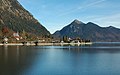
Picture gallery

The Walchensee from Simetsberg seen
The village of Walchensee

Sunrise at Walchensee

Evening lighting at Walchensee

Boat dock

Taken from the boat dock


See also
literature
- Cornelia Oelwein: The history of the Walchensee and its fishing . Edition Alpenblick & Seenland, Uffing am Staffelsee 2010, ISBN 978-3-9813813-0-6
- Martin Siepmann, Brigitta Siepmann (Ed.): Landscape in Bavaria . Bayerland, Dachau 1995, ISBN 3-89251-200-0
- Lovis Corinth: Walchensee . Piper, Munich 1984, ISBN 3-492-02179-4
- Josef Rambeck: The Barabers from Walchensee . German Building Trade Association, Berlin 1931
- Emil Becker: The Walchensee and the Jachenau. Erfurt 1897
Web links
Individual evidence
- ↑ a b c d e Documentation of the condition and development of the most important lakes in Germany: Part 11 Bavaria (PDF; 1.7 MB)
- ↑ a b Information sheet from the Weilheim Water Management Office (PDF; 59 kB)
- ↑ Documentation of the condition and development of the most important lakes in Germany: Foreword (PDF; 471 KB) ( Memento from April 11, 2016 in the Internet Archive )
- ^ State Office for the Environment: Lakes in Bavaria
- ↑ Telephone statement from the branch manager of the municipality of Kochel am See on March 11, 2015 to the branch manager of the municipality of Jachenau that the Bayerische Staatsforsten AöR is registered as the owner of the plot number 3.300
- ↑ http://www.baysf.de/fileadmin/user_upload/GIS/RevSitz.html
- ^ See, for example, Schweizerisches Idiotikon , Volume XV, Column 1422 ff., Article Walch I ( digitized version ).
- ↑ Jaqueline Reber: Structures and patterns in the world of names, quantitative and qualitative studies on the stock of toponyms of the two Solothurn offices of Dorneck-Thierstein and Olten-Gösgen . A. Francke, Tübingen 2014, ISBN 978-3-7720-8533-8 , p. 216 .
- ↑ Alois Geistbeck: The South Bavarian and North Tyrolean lakes. In: Journal of the German and Austrian Alpine Association, year 1885, Volume XVI, pp. 334–354 , here pp. 341–343
- ↑ Map with Desselwand ( Memento from June 1, 2016 in the Internet Archive )
- ↑ The Landspitze Desseleck is not shown on the current official topographical map , but it is on the historical land map , there in the spelling Deſsel⸗Eck with a long s and separated by a double hyphen . On Adrian von Riedl's map of the Walchensee and Kochelsee from 1806 the entry Deſslek can be found with an exuberant e. However, this entry is not placed on the headland, but near the Desselkopf .
- ↑ Alois Geistbeck: The South Bavarian and North Tyrolean lakes. In: Journal of the German and Austrian Alpine Association, year 1885, Volume XVI, pp. 334–354 , here p. 342
- ↑ a b Edwin Fels: Depth map of the Walchensee (1928) ( Memento from February 12, 2015 in the Internet Archive )
- ↑ Edwin Fels: New plumbing of the Walchensee. Journal of the Society for Geography in Berlin, 1922, pp. 145–147 (small communications)
- ↑ Writing on the way in the two-lake region , Kochel am See municipality, March 2018, p. 21
- ↑ Birk, Hildegard, Karl Meichelbecks Brief Freisingsche Chronik , Freising 2008, p. 174, ISBN 978-3-927067-38-7
- ^ Upper Bavaria district: Crayfish for Walchensee . September 16, 2003
- ↑ Windsurfing at Walchensee
- ↑ Diving in Walchensee - TSC-Barracuda. Retrieved April 1, 2019 .
- ^ Tölzer Kurier, August 29, 2008, page 4
- ^ Tölzer Kurier, September 26, 2008, page 5
- ↑ SWR press service of September 21, 2009