
Eschenlaine
| Eschenlaine | ||
 Catchment area of the Eschenlaine |
||
| Data | ||
| Water code | DE : 16256 | |
| location |
Bavaria
|
|
| River system | Danube | |
| Drain over | Loisach → Isar → Danube → Black Sea | |
| origin | 1.4 km west of Kochel am See - Einsiedl 47 ° 34 ′ 20 ″ N , 11 ° 17 ′ 16 ″ E |
|
| Source height | approx. 901 m above sea level NHN | |
| muzzle | from the right into the Loisach near Eschenlohe Coordinates: 47 ° 35 '56 " N , 11 ° 11' 21" E 47 ° 35 '56 " N , 11 ° 11' 21" E |
|
| Mouth height | approx. 635 m above sea level NHN | |
| Height difference | approx. 266 m | |
| Bottom slope | approx. 27 ‰ | |
| length | 9.8 km | |
| Catchment area | 35.15 km² | |
 Eschenlaine in the Eschenlainetal |
||
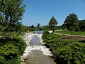
The Eschenlaine is a nearly 10 km long forest stream in Upper Bavaria that runs approximately west-northwest and flows into the Loisach from the right on the outskirts of Eschenlohe . The Eschenlaine flows through the Eschenlainetal , which connects the Walchenseekessel with the Loisach valley and borders the Estergebirge in the north.
geography
course
The Eschenlaine rises at about 901 m above sea level. NHN a little west of a 906 m above sea level. NHN high saddle, its watershed to the nearby Walchensee. Initially, the border between the communities of Wallgau in the Garmisch-Partenkirchen district with the brook and the left slope and Kochel am See in the Bad Tölz-Wolfratshausen district with the right slope runs on the right bank . After the inflow of the Grießlaine from the north, its largest tributary, it changes to the municipality of Eschenlohe in the district of Garmisch-Partenkirchen. Shortly before the confluence of the Kessellaine , near the Am Juchzer corridor , the Eschenlaine is dammed up to form a small lake, which is now largely gravel .
Immediately below the dam, it enters the 500 m long Gachentodklamm . After the gorge, the valley widens again and the Eschenlaine continues to flow in a west-northwest direction. After the brook has passed the Wengwies wasteland , which is about 500 m north and about 120 m above it in a cleared island, depending on the water level, the majority of the water of the Eschenlaine seeps away , which is why it is largely dry from there to the mouth. There the valley narrows again to the approximately 600 m long Asamklamm , which today is named after the Councilor Dr. Wilhelm Asam (1862–1944) and was formerly called Schwarze Brüll Klamm . At the lower end of Eschenlohe the Eschenlaine flows out to about 635 m above sea level. NHN in the Loisach.
Catchment area
The Eschenlaine drains an area of approx. 35 km², from the Simetsberg ( 1840 m above sea level ), the Platteneck ( 1804 m above sea level ) and the Hohen Kisten ( 1922 m above sea level ) in the south, as well as the Heimgarten ( 1791 m above sea level ), the Hirschberg ( 1660 m above sea level ), the Ölrain ( 1542 m above sea level ) and the Osterfeuerkopf ( 1368 m above sea level ) in the north. The only settlement in it besides the estuary is the mentioned Wengwies.
Tributaries
Hierarchical list of the tributaries from the source to the mouth. Selection.
- Main ditch, from the left and south-southwest
- Schiecher Graben, from the right and northeast
- Grandelgraben, from the left and south
- Grießlaine, from the right and north-northeast, 4.6 km and 6.8 km²
- Sharp ditch, from left and east
-
Erzlaine , from the right and north
- Oil trench, from the right and west-southwest
- Simetsgraben, from the left and west-southwest
-
Kessellaine , from the left and east-southeast
- (Stream from the Möseltal ), from the left and southwest
- Pustertallaine , from the left and south-west
- (Bach from the Judental ), from the right and northeast
-
Hirschlaine , from the right and northwest
- Eckleitengraben (longer upper course), from the left and east-northeast
- (Bach from the Hanselgraben ), from the right and north-northeast
- (Creek from the gorge ditch ), from the right and north-northeast
- Urlaine , from the left and southeast in Eschenlohe
geology
Main dolomite is to be found on the surface almost in the entire catchment area of the Eschenlaine . Tectonically, this belongs to the so-called Lech Valley cover of the northern Limestone Alps . The Asamklamm is an officially designated geotope (geotope number: 180R024). A footbridge leads over the gorge.
tourism
A farm road runs through the Eschenlainetal from Eschenlohe to Einsiedl am Walchensee. Since this has only a relatively small difference in altitude of 270 m and only a few but steep climbs, it is popular not only with hikers, but also with mountain bikers . He crosses the Grießlaine shortly before its confluence with the Eschenlaine through a ford . The path through the Eschenlainetal is part of the mountain bike circuit “Around the Herzogstand”.
photos

Headwaters of the Eschenlaine
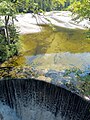
Reservoir of the Eschenlaine near the "Am Juchzer" corridor

Eschenlaine in the Eschenlainetal. In the background the Simetsberg

Eschenlaine in the Asamklamm
The Eschenlaine flows into the Loisach

In the ravine with a brook


Web links
Individual evidence
- ↑ a b Height inquired (with right click) on: BayernAtlas of the Bavarian State Government ( information ) ( detailed map )
- ↑ a b c Length and catchment area according to: List of creek and river areas in Bavaria - Isar river area, page 20 of the Bavarian State Office for the Environment, as of 2016 (PDF; 2.5 MB) (see also the following page; the page numbers may change) .
- ↑ Sign 11 of the Ammergau Alps meditation trail in the Blue Land.
- ↑ a b c d e f g Height according to black lettering on the background layer Topographic map on: BayernAtlas of the Bavarian State Government ( information ) ( detailed map )
- ^ Geological map of Bavaria, 1: 25000, 8433 (Eschenlohe), publisher: Bavarian State Office for the Environment
- ↑ Geotop Description Asamklamm
- ^ Official topographic map of Bavaria ATK25, sheet R10 (Wallgau), publisher: Bavarian State Office for Digitization, Broadband and Surveying