
Loisach


The Loisach is a 113.2 km long, south-southwestern and left tributary of the Isar in Austria and Germany . It rises north of the Fern Pass in Tyrol and flows northeast near the Bavarian Wolfratshausen .
etymology
The name is based on the Indo-European word leubh , which means dear. It is derived with an s as a suffix . The name refers to the pleasant course of the river. Earlier forms of the name are Liubasa (1003), Lyubasa (approx. 1052), Liubisaha (1148–1155), Livbisaha (12th century), Liubsaha (1258), Leusach (1332), L e usach (1348), Lewsach (1424) , Loysach (1536) and finally Loisach in 1553 .
course
From the source to the Bavarian border
The Loisach rises in the state of Tyrol between the Lechtal Alps in the west and the Mieminger Mountains in the east, below or north of the Fernpass . Their sources are located in the municipality of Biberwier near the Mittersee near the B 179 . From there, its water flows north through the Ehrwald Basin and then along the B 187 through Ehrwald and west past the Zugspitze to the German border.
From Garmisch-Partenkirchen to the Kochelsee
On the Bavarian side it first passes Griesen to the northeast and then flows past Grainau to Garmisch, the largest district of Garmisch-Partenkirchen. Then it runs further north between the Ammergau Alps in the west and the Ester Mountains in the east.
Via Farchant , Oberau and Eschenlohe and past Ohlstadt and Murnau , the Loisach reaches Großweil , where it bends to the southeast and flows into the western part of the Kochelsee near Schlehdorf north of the Herzogstand .
From the Kochelsee to the confluence with the Isar
It leaves the lake on its northern edge west of Kochel , passes Benediktbeuern and Penzberg and there finally leaves the northern foothills of the Bavarian Alps . It still flows through Eurasburg and flows into the Isar north of Wolfratshausen in the Pupplinger Au forest .
Tributaries
The most important tributaries of the Loisach are on the right-hand side the Hammersbach from the Höllental , the Partnach near Garmisch-Partenkirchen, the streams Kuhflucht near Farchant, Röhrlbach and Lauterbach near Oberau and the Mühlbach near Eschenlohe as well as the Eschenlaine near Eschenlohe, the cold water lake near Ohlstadt and the Lainbach coming from the Benediktenwand . On the left, the Loisach receives a notable tributary at Griesen from the Neidernach , at Oberau from the Gießenbach and at Murnau via the Ramsach , which drains the entire Murnauer Moos .
Amount of water
According to the information provided by the Bavarian flood intelligence service about the mean discharge of the Loisach in Beuerberg and the Loisach-Isar Canal in Bruggen, an average of 54 m³ / s flow off before Wolfratshausen. The value is higher than the natural runoff because water is supplied from the Isar via the Walchensee power plant . Without this contribution of almost 20 m³ / s from the Isar system, there remains a discharge of almost 35 m³ / s, making the Loisach the second largest tributary of the Isar after the Amper .
Interventions by humans
Constructions
Bank protection was built on the Loisach as early as 1900. In addition, it has been straightened in places, e.g. B. in the locality of Garmisch, near Murnau and north of the Kochelsee. Former river loops were cut off and in places have been preserved as backwaters , e.g. B. east of Penzberg. The goals of straightening can be flood protection, peat drainage and improvement of traffic conditions. The necessary space for the alignment of the railway line and road in the narrow Loisach valley west of Grainau could only be created by straightening and building the Loisach.
The Trift Canal connects the sections above and below the Kochelsee for the purpose of rafting.
Renaturation and flood protection
Garmisch-Partenkirchen
Between 1992 and 1997, the river bed was renatured in three sections for a total of 4.88 million DM . The enlarged drainage cross-section reduces the risk of flooding and allows the river bed to develop a certain dynamic of its own within the framework of new bank protection designed to be close to nature, which in turn improves the self-cleaning power and the ecological development potential. In addition, base ramps reduce the previously strong deep erosion. Since then, the Loisach has again conveyed closeness to nature and accessibility with widened banks.
Eschenlohe
After the village of Eschenlohe was badly hit by the Whitsun floods in 1999 and the Alpine floods in 2005 , construction measures were carried out over 2 km to protect the place from future flood events of this magnitude. Among other things, a 1000 m long bank wall and a new bridge were built that crosses the Loisach without damming piers.
Hydropower plants
The water from the Loisach is used by various power plants to generate energy.
In operation
- In Garmisch-Partenkirchen on the Loisachwehr, there has been a power plant again since 2011, after a previous building was badly damaged by a flood in 1920. The new power plant delivers 2.20 GWh of electricity per year, which is sufficient to supply around 600 households.
- The run-of-river power plant in Farchant has a Kaplan turbine with an output of 400 kW. There is also a condensation boiler , two diesel generators with an output of 350 kW each and an emergency power generator with an output of 1,500 kW.
- The Schönmühl hydropower plant is a run-of-river power plant with an output of 5 MW.
Planned
Another power plant is planned in Großweil. A modern shaft power plant is to be built here, the facilities of which are largely under water. However, protests formed against the power plant, as it is to be built in the FFH area Murnauer Moos . The shaft power plant was approved in spring 2016. In spring 2016, the legal dispute over the Großweil power plant was settled with a compromise in compliance with stricter environmental and fish protection requirements.
photos

Source swamp of the Loisach near Biberwier
Loisach near the source near Biberwier, Tyrol

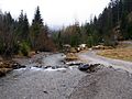
Loisach west of Garmisch-Partenkirchen

Loisach near Penzberg- Maxkron

The Loisach flows into the Isar (from the right)
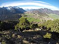
Loisach valley from the north


Trivia
Loisach is also the name of the fictional location of the early evening series Schafkopf on ZDF .
literature
- Karl Wolf: Rafting and Trift on the Upper Loisach . In the 2011 yearbook of the historical association Murnau am Staffelsee e. V. pp. 25-120
- Christian Wolkersdorfer: Course of the Paläoloisach in Ausserfern - An attempt at reconstruction . In Geoforum Umhausen, Umhausen 20 (2018), pp. 192–200 (PDF; 1.1 MB)
Web links
- Water level reports on hnd.bayern.de
- Photos from the Loisach flood in 2005 near Benediktbeuern / Kochel , on artweise.de
- Pictures of the 2005 flood in Eschenlohe , on validom.de
- Loisach renaturation measures , April 18, 2000, on uni-weimar.de
- Flood protection measures for the municipality of Oberau ( Memento from August 16, 2010 in the Internet Archive ) on the homepage of the Weilheim water management office
Individual evidence
- ↑ a b c Directory of stream and river areas in Bavaria - Isar river area, page 14 of the Bavarian State Office for the Environment, as of 2016 (PDF; 2.5 MB)
- ^ Deutsches Gewässerkundliches Jahrbuch Danube region 2006 Bavarian State Office for the Environment, p. 197, accessed on October 4, 2017, at: bestellen.bayern.de (PDF, German, 24.2 MB).
- ↑ Wolf-Armin Frhr. v. Reitzenstein : Lexicon of Bavarian place names. Origin and meaning . CH Beck, Munich 2006, ISBN 3-406-55206-4 , p. 156 .
- ↑ Wolf-Armin Frhr. von Reitzenstein : Lexicon of Bavarian place names. Origin and meaning . 2nd, improved and enlarged edition. Verlag C. H. Beck, Munich 1991, ISBN 3-406-35330-4 , p. 230
- ↑ Eschenlohe protected from floods. Merkur-online.de, September 16, 2007, accessed April 7, 2013 .
- ↑ New Loisach power plant put into operation. Merkur-online.de, July 15, 2011, accessed on April 7, 2013 .
- ↑ The factory - Farchant power plant on tour. Farchant A. Poettinger & Co. KG power plant, accessed April 7, 2013 .
- ↑ Großweil accelerates. Municipal Works Garmisch-Partenkirchen, accessed on April 7, 2013 .
- ↑ Hydroelectric power station: There is a complaint. Merkur-online.de, January 31, 2013, accessed April 7, 2013 .
- ↑ shaft power plant
- ↑ Tanja Brinkmann: Schachtkraftwerk Großweil: Significant delay. merkur.de, April 28, 2015, accessed November 4, 2015 .
- ^ Free path for hydropower in Großweil. In: https://www.merkur.de/ . Retrieved April 11, 2016 .
- ↑ Schafkopf ( memento from February 17, 2013 in the web archive archive.today ). In: zdf.de , September 28, 2012.