
Duke's estate
| Duke's estate | ||
|---|---|---|
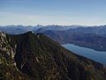
 View from Sachsenbach am Walchensee to the Fahrenbergkopf (left), Martinskopf (middle) and Herzogstand (right) |
||
| height | 1731 m above sea level NN | |
| location | Germany ( Bavaria ) | |
| Mountains | Bavarian Prealps | |
| Coordinates | 47 ° 36 '52 " N , 11 ° 18' 36" E | |
|
||
| rock | Main dolomite | |
| Age of the rock | Triad | |
| Normal way | Herzogstandbahn (mountain station) - Herzogstand | |


The Herzogstand is a mountain in the Bavarian Prealps at 1731 m above sea level. NN northwest of the Walchensee . It belongs to the area of the municipality of Kochel am See and, together with its neighbor Heimgarten, forms a ridge that is in front of the Estergebirge and drops to the north into the Bavarian Alpine foothills .
During the Würm glacial period, the Herzogstand was a so-called nunatak , i.e. a mountain whose summit protruded approx. 330 m from the ice flow. The Kesselberg , the cut between Herzogstand and Jochberg , was an alpine gate ; here a branch of the Isar-Loisach glacier , which in turn was a branch of the Inn glacier , flowed through it at an altitude of approx. 1400 m above sea level.
history
The Herzogstand got its name in 1535 from the Bavarian Dukes Wilhelm IV and Ludwig X. Since 1865 at the latest, there has been a viewing pavilion on the summit .
The Wittelsbach built in 1857 below the present Herzogstandbahn house the estate. King Ludwig II had the so-called royal house built in 1865 . The Herzogstandbahn , a cable car renovated in 1994 , leads to the Fahrenbergkopf at 1627 m . Somewhat below is the Herzogstandhaus, which was rebuilt after a fire in 1992, at an altitude of 1575 m . To the northwest of it and south of the Herzogstand summit is the Martinskopf ( 1675 m ).
The Herzogstand is one of Munich's most famous local mountains and is widely used with and without cable car support in all seasons.
Transmitter on the summit
The Herzogstand has been used for radio technology since 1920. From 1920 to 1934, a transmission antenna for longitudinal waves was attached to the Herzogstand , which belonged to the radio station at the Herzogstand . Today the Herzogstand transmitter is located 900 m southeast of the Herzogstand summit on the Fahrenbergkopf ( 1627 m ) .
Hiking trails
The shortest approach (AV route 446) leads from the south from the valley station of the cable car in Walchensee to the Herzogstandhaus and on to the summit (2.5 hours). From the east, the so-called bridle path leads from the Kesselberg -Passhöhe to the Herzogstandhaus (also indicated with 2.5 hours). Much longer and rarely used is the access from the north from the Kochelsee via the Pionierweg . Finally, the summit of the Herzogstand is also accessible from the west via the somewhat exposed, but well-secured ridge from Heimgarten ( 1790 m ); This popular tightrope walk is characterized by the fact that you have a view of the Kochel and Walchensee, the Munich plain and the high mountains. When arriving by car, the Walchensee-Heimgarten-Herzogstand-Walchensee circular hike is recommended, and when using public transport, the crossing from Ohlstadt .
The crossing of Heimgarten-Herzogstand (but with the much longer approach from Eschenlohe through the Judental ) is part of the Maximiliansweg and thus also of the European long-distance hiking trail E4 . After the Kesselberg, this path continues over the Jochberg to the Tutzinger hut on the Benediktenwand . The Via Alpina also coincides with the Maximiliansweg on these stages.
gallery

View from Heimgarten on the ridge to the Herzogstand

View from Großweil to Herzogstand and Heimgarten
View of the Fahrenbergkopf

View over Kochelsee to the Herzogstand (center)

The Herzogstand around 1900


Web links
- Tour description
- Herzogstand-Bahn
- Mountain inn Herzogstand
- kochel.de official website of the municipality of Kochel a. lake
Individual evidence
- ↑ Geological map of Bavaria with explanations (1: 500,000). Bavarian Geological State Office, 1998.
- ↑ Chronicle of the Herzogstandhaus , accessed on April 17, 2018
- ↑ See illustration in: Chronicle of the Herzogstandhaus , accessed on November 9, 2018