
Ester Mountains
| Ester Mountains | |
|---|---|
 Estergebirge and surroundings |
|
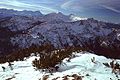
 Ester Mountains from the southeast |
|
| Highest peak | Krottenkopf ( 2086 m ) |
| location | Bavaria |
| part of |
Bavarian Alps in the Northern Eastern Alps |
| Classification according to |
AVE : 7b SOIUSA : 22.IV |
| Coordinates | 47 ° 33 ' N , 11 ° 11' E |
| surface | 101 km² |
The Ester Mountains , also known as the Krottenkopf Mountains , are located in the Bavarian Alps between the Loisach and Isar valleys and are therefore part of the Northern Limestone Alps . To the north it is bounded by the Eschenlaine , which excludes the Heimgarten - Herzogstand ( Walchenseeberge ) ridge, which is often added .
The Estergebirge is one of the largest contiguous karst areas in the Bavarian Alps .
geography
Most important peaks
Important peaks are the Krottenkopf ( 2086 m ), the Bischof ( 2033 m ), the Hohe Kisten ( 1922 m ), the Hohe Fricken ( 1940 m ) and the Simetsberg ( 1836 m ). The climbs both from the Loisach Valley and from the south-east of Krün and Wallgau are relatively long, which is why the Ester Mountains are still quite quiet with the exception of Wank ( 1780 m ), which is accessible by a cable car from Garmisch-Partenkirchen, with the Wankhaus, which is managed almost all year round .

Summit from north to south
The mountains lie between the places Eschenlohe, Oberau, Farchant, Partenkirchen, Krün and Wallgau.
- Simetsberg ( 1836 m )
- Neuglägerkopf ( 1491 m )
- Boiler heads ( 1594 m )
- Platteneck ( 1804 m )
- Wallgauer Eck ( 1769.4 m )
- Gaping ( 1829 m )
- Elferköpfl ( 1412 m )
- Zwölferköpfl ( 1656 m )
- High boxes ( 1922 m )
- Zundereck ( 1478 m )
- Zunderkopf ( 1506 m )
- Archtalkopf ( 1927 m )
- Schindlerskopf ( 1940 m )
- Upper Risskopf ( 2049 m )
- Kareck ( 2046 m )
- Henneneck ( 1964 m )
- Krottenkopf ( 2086 m )
- Bishop ( 2033 m )
- Hoher Fricken ( 1940.4 m )
- Amelsberg ( 1741 m )
- Wank ( 1780 m )
- Rosswank ( 1688 m )
- Vorderer Riedberg ( 1662 m )
- Rotenkopf ( 1685 m )
- Zunderkopf ( 1611 m )
- Mitterkopf ( 1529 m )
- Bletschertal head ( 1358 m )
- Rindberg ( 1310 m )
- Schafkopf ( 1305 m )
- Krepelschrofen ( 1160.3 m )
caves
- Fishing hole
- Frickenhöhle in the area of the Kuhflucht waterfalls near Farchant
Geology and hydrology
The southern and northern flanks of the Estergebirge consist of main dolomite , which was deposited in the north , a level of the Upper Triassic , about 220 million years ago in a shallow part of the Tethys , the Meliata Ocean. The main dolomite forms a hollow in the central part of the Estergebirge, so that a contiguous area of the somewhat younger plate limestone could be preserved above it. The most important peaks (Hoher Fricken, Bischof, Krottenkopf, Hohe Kisten, Simetsberg) are built from this. The Plattenkalk is an important karst former. Between Krottenkopf, Klaffen and Hohe Kisten there is an extensive, approx. 1.5 km² karst area (Michelfeld, Angerlboden, Kühalm) at an altitude of 1600 to 1700 m, in which numerous sinkholes and ponors have formed. The karst area is drained underground through fissures and caves in the direction of Loisach (Michelfeld, Angerlboden) or Walchensee (Kühalm, Wildsee ). The karst waters emerge from karst springs , such as the Kuhfluchtquelle , on the western and eastern flanks of the limestone area. The underground drainage system was verified by marking tests between 1967 and 1973. Important surface drains are the Eschenlaine in the north and the Finzbach in the south.
Excursion possibilities
Both summer and winter tours are possible in the Estergebirge. Two DAV huts are in this mountain region. The Weilheimer Hütte on the Krottenkopf is an important starting point for the tours. The Wankhaus is in the immediate vicinity of the Wankbahn.
A worthwhile tour goes to the Kuhfluchtfall on the Hohe Fricken, which can be seen from Farchant . The stream rises in the middle of a vertical rock wall in a thick stream (depending on the weather). There you can also observe a slow landslide , the movement of which has been measured for years by geologists using lasers based on measuring points anchored in the rock. A sign that is clearly visible to laypeople is a “drunken forest” (these are trees inclined in different directions), which is caused by movements of the slope.
When using public transport, interesting crossings and crossings are possible (train stations in Ohlstadt , Eschenlohe , Oberau , Farchant , Garmisch-Partenkirchen , Klais ; Kochel am See - Walchensee - Wallgau bus route ).
literature
- Eugen E. Hüsler: Isarwinkel Bad Tölz - Lenggries - Kochel , Bergverlag Rother , Ottobrunn 2004, ISBN 978-3-7633-4006-4
- Topographic map of the area , UK50, sheet 51 (Karwendel), State Office for Surveying and Geoinformation Bavaria (today: State Office for Digitization, Broadband and Surveying Bavaria ), scale 1: 50000, ISBN 978-3-89933-285-8
- Geological map of Bavaria , GK25, sheet 8433 (Eschenlohe), Bavarian State Geological Office (today: Bavarian State Office for the Environment ), scale 1: 25000
photos

The Krottenkopf (October 2004)

View in southwest direction on the Bischof ( 2033 m ) from the Krottenkopf ( 2086 m )

The Hohe Fricken from the Bishop , in the background the Zugspitze
View from the summit of the Simetsberg to the western Estergebirge


Web links
- Estergebirge on steinmandl.de
- Estergebirge in the Bavaria Atlas
Individual evidence
- ↑ The chairman of the "Association for Local and Field Name Research in Bavaria eV", in cooperation with the State Surveying Office responsible for naming and extending them to Bavarian maps, confirmed the Eschenlainetal as the northern border of the Estergebirge unreservedly from onomatological and historical reasons.
- ↑ Explanations of the Geological Map of Bavaria, scale 1: 25000, sheet 8433 (Eschenlohe), publisher: Bavarian State Office for Geology, Munich, 1976