Tall boxes
| Tall boxes | ||
|---|---|---|
|
The striking summit structure of the Hohe Kisten (left) in the ridge of the Estergebirge |
||
| height | 1922 m above sea level NN | |
| location | Bavaria , Germany | |
| Mountains | Ester Mountains | |
| Dominance | 1.03 km → Archtalkopf | |
| Notch height | 87 m | |
| Coordinates | 47 ° 33 '43 " N , 11 ° 12' 33" E | |
|
|
||
| Normal way | Wallgau - Wildsee - high boxes | |
|
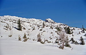
The small summit triangle of the Hohe Kisten from the south. |
||
The high boxes is a 1922 m above sea level. NN high mountain in the Ester Mountains in the Bavarian Prealps and is located north of the Krottenkopf - the main peak of the Ester Mountains.
The Hohe Kisten is a mountain with two sides, a rocky north side, on which the structure of the summit looks like a large box, and a tame south side, on which the summit is barely visible.
The summit can be reached as an easy mountain tour from Wallgau . The ascent from Eschenlohe in the Loisach Valley through the Puster Valley requires perseverance and surefootedness . Another access is the path from the Weilheimer Hütte ( 1946 m ) running near the ridge . This makes it a good idea to cross the Hohe Kisten : for example as a very long day tour Eschenlohe-Hohe Kisten-Weilheimer Hütte- Oberau (using the Munich-Garmisch-Partenkirchen railway ) or as part of a longer tour through the Estergebirge.
In the 1970s it was planned to build a cable car from Eschenlohe to the summit of the Hohe Kisten. The project, which also provided for several ski lifts, failed due to resistance from the Federal Nature Conservation Union .
Web links
Individual evidence
- ^ Official map - digital local map 1:10 000. In: BayernAtlas. State Office for Digitization, Broadband and Surveying Bavaria , accessed on January 23, 2016 .
- ^ Peter Adam, Anton Jocher: The street names of Garmisch-Partenkirchen . Adam Verlag, Garmisch-Partenkirchen 2001, ISBN 3-924308-34-9 , p. 104 .


