
Krottenkopf
| Krottenkopf | ||
|---|---|---|
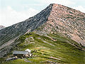
 Krottenkopf (2086 m) from the Bischof (2033 m) in the Ester Mountains |
||
| height | 2086 m above sea level NN | |
| location | Bavaria , Germany | |
| Mountains | Ester Mountains | |
| Dominance | 12.7 km → Lower Wettersteinspitze | |
| Notch height | 1156 m ↓ Klais | |
| Coordinates | 47 ° 32 '40 " N , 11 ° 11' 29" E | |
|
||
| rock | In the summit area of Oberrätkalk, otherwise main dolomite | |
| Age of the rock | Triad | |
| Normal way | Partenkirchen - Esterbergalm - Weilheimer Hut - Krottenkopf | |

At 2086 m, the Krottenkopf is the highest mountain in the Bavarian Prealps .
Location and climbing possibilities
It is located in the westernmost part of the Bavarian Prealps in the Ester Mountains near Garmisch-Partenkirchen . Just below and half an hour from the summit is the Weilheimer Hütte (1955 m), the highest alpine club hut in the Bavarian Prealps.
There are the following climbing options:
- From Oberau the quite steep Oberauer Steig , which leads over narrow mountain paths, leads over the Frickenboden and later past the also over 2000 m high, but lesser-known Bishop . Approx. 4 hours are estimated for this ascent.
- Another path leads from Klais over the Krüner Alm (1620 m) and the Michelfeld.
- From Garmisch-Partenkirchen or Farchant you can reach the summit of the Krottenkopf via the Esterbergalm in about 4½ hours.
- There is also the somewhat longer ascent from Eschenlohe past the 1922 m high Hohe Kisten to the summit.
Name declaration
Like many other mountain names, the origin of the name of the Krottenkopf has not been clearly established. One possibility is that the name from the family name that Krott derived, another says that the mountain toads (in dialect Krotten called) to have lived below the mountain, the mountain gave the name. According to a third theory, the name comes from the old words Grott , Grutt or Krutt , which mean rubble or stony terrain .
Since, according to locals, there are neither mountain toads nor a lot of rubble on the mountain and there is no evidence of a family named Krott in the registration list , another plausible naming of the two peaks of the Estergebirge - Krottenkopf and Bischof - can probably be based on their shape or form. Explain silhouette. (The peaks can only be seen from the Isar valley between Mittenwald and Krün.) The southern one has the shape of a crouching toad, in Krüner dialect "Krout'n", while the northern one has the silhouette of a bishop's hat / miter. Visually similar peaks can be found, which are also called “Bishop” and “Bischofsmütze”. The problem is that the peaks in the Estergebirge were originally called that, but were probably reversed when the Royal Bavarian Map System was revised in the middle of the 19th century, and this fact has been wrongly left that way to this day.
Web links
- Tour description
- Tour description in winter with pictures
- Labeled summit panorama from the Krottenkopf
- Tour description over the Oberauer Steig including map and photos
photos
Krottenkopf around 1900

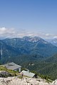
View from the Krottenkopf to the Risskopf
View from the Heimgarten , in the foreground the Heimgartenhütte


Individual evidence
- ^ Bavarian Geological State Office, 1998, Geological map of Bavaria with explanations 1: 500,000
- ^ Peter Adam, Anton Jocher: The street names of Garmisch-Partenkirchen . Adam Verlag, Garmisch-Partenkirchen 2001, ISBN 3-924308-34-9 , p. 104 .