
Cow Escape Falls
| Cow Escape Falls | ||
|---|---|---|
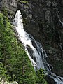
 Panorama of the lower waterfall |
||
| Coordinates | 47 ° 31 '32.3 " N , 11 ° 7' 54.9" E | |
|
||
| place | near Farchant , Germany | |
| Falling watercourse | Cow ditch | |
| Estuarine waters | Loisach | |

The Kuhflucht waterfalls are a group of three waterfalls above Farchant near Garmisch-Partenkirchen in Bavaria . The three fall levels add up to approx. 270 m and are therefore among the highest in Germany .
A sign explains the name as follows: “The name Kuhflucht is probably derived from the Romans : confluctum, the confluence of this stream with the Loisach . The water comes from the plateau between Krottenkopf and Simetsberg and arises from several karst springs in the Plattenkalk, the catchment area of which is about 5 km². The main source is the Kuhfluchtquelle , which rises from the 200 m high end wall of the Kuhfluchtgraben. (Waterfall straight out of the wall, visible from Partenkirchen). “The average discharge of all springs is around 1500 liters per second.
Hikers can reach the falls most comfortably from Farchant in a one hour walk.
Geotope
The cattle escape source has been designated by the Bavarian State Office for the Environment as a particularly valuable geotope (geotope number: 180Q002).
Upper waterfall
and karst spring
Middle waterfall

Lower waterfall

waterfall


See also
Individual evidence
- ↑ Bavarian State Office for the Environment, Geotop Kuhfluchtquelle near Farchant (accessed on October 19, 2017).