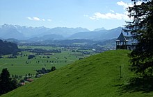
Bavarian Alpine Foreland
| Bavarian Alpine Foreland | |
|---|---|
| Systematics according to | Handbook of the natural spatial structure of Germany |
| 1st order natural space | Alpine foothills |
| state | Bavaria |
| Country | Germany |

The Bavarian Alpine Foreland is part of the Alpine Foreland . It extends in the area south of the Danube , which includes flat areas and hilly foothills as far as the Bavarian Alps . In the west and east it is limited by the Bavarian border.
Emergence
When the African continental plate was pushed onto the European continental plate in the Tertiary Age, the Molasse Basin was created , which absorbed enormous amounts of eroded rubble. Today this forms the bottom of the Bavarian Alpine foothills.
In the southern part these molasse layers were reshaped by the influence of the glacier advances from the central Alps during the Quaternary Ice Ages . The last advance of the glaciers during the Würm glacial period is responsible for the current appearance . The glaciers transported masses of earth and rock until shortly before Munich and deposited them in the characteristic hilly landforms for which the Bavarian Alpine foothills are known today.
The many Bavarian lakes were scraped out of the molasse bed by the glaciers (e.g. Ammersee , Starnberger See ) or were created later when the glaciers retreated through blocks of dead ice separated from the main tongue (e.g. the Osterseen ). The ice masses, which liquefied when the glacier melted, washed up large amounts of gravel over several ice ages . This is how the Munich gravel plain was created , which, in contrast to other Bavarian sands, is characterized by its very spacious expansion.
In summary, the moraine hills , gravelly sand and lakes in this area document the elements of the glacial series .
Geography and geology

In the north, the Bavarian Alpine foothills are bounded by the Danube. The western boundary forms the border between the administrative district of Swabia (Bavaria) and Baden-Württemberg and the eastern boundary is the border river Salzach . It extends up to the alpine and pre-alpine elevations of the Bavarian Alps.
The largest city in the region is Munich , which lies in the middle of the Alpine foothills on the Isar. The Bavarian foothills of the Alps is also characterized by some meadow landscapes and forest areas.
The Bavarian Alpine Foreland is u. a. traversed by the rivers Iller , Wertach , Lech , Ammer , Loisach , Isar and Inn , which at least in the Alps often follow the earlier course of the glacier tongues. The lakes created in the terminal moraine landscapes partly protrude into the Alps ( Lake Constance , Tegernsee , Starnberger See , Chiemsee etc.).
Notable elevations in the Bavarian Alpine foothills are the Burgkranzegger Horn in the Rottachberg ridge with 1150 m , the Ursersberg in Adelegg with 1129 m , the Auerberg with 1055 m or the Hohe Peißenberg with 988 m . Some larger elevations are upstream in the flatter area further north, e.g. B. the Auerberg , the Hohe Peißenberg or the Taubenberg .
Natural structure
In the natural spatial structure , according to the manual of the natural spatial structure of Germany , which has served as the standard work since the 1950s , a distinction is made between four major natural spatial regions on German soil . These four regions of the northern foothills of the Alps are the Donau-Iller-Lech-Platte (04), the Isar-Inn-Schotterplatte (05), the lower Bavarian hill country (06) and the pre-alpine hill and moorland (03). The latter is also known as the southern foothills of the Alps - the same name as the southern foothills of the Alps , which is almost entirely in Italy and extends to Slovenia.
In subsequent publications of the 1990s (single sheets Lindau and Kaufbeuren, Hansjörg Dongus), the northern foothills of the Alps were also mentioned in part. In addition, the new greater region of Nagelfluhhöhen and Senken between Lake Constance and Wertach (02) was split off with Adelegg and Pfänder . The part of the Bavarian foothills of the Alps remaining as Region 03 is referred to as Subalpine Jungmoränenland .
Web links
- Website of the Upper Bavarian Alpine Foreland

