Auerberg (Allgäu)
| Auerberg
Swabian Rigi
|
||
|---|---|---|
|
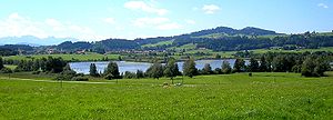
View from the east-northeast over the Haslacher See to the Auerberg |
||
| height | 1055 m above sea level NHN | |
| location | between Bernbeuren and Stötten ; Districts Weilheim-Schongau and Ostallgäu , Bavaria ( Germany ) | |
| Mountains |
Allgäu ( Bavarian Alpine Foreland ) |
|
| Coordinates | 47 ° 44 '8 " N , 10 ° 44' 8" E | |
|
|
||
| particularities | Suspected Celtic fortress Damasia on the summit | |

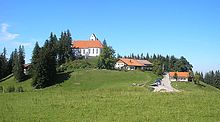
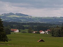
The Auerberg , also called Swabian Rigi , is 1055 m above sea level. NHN high mountain of the Allgäu, part of the Bavarian Alpine Foreland . It is located in the municipal areas of Bernbeuren in the district of Weilheim-Schongau ( Upper Bavaria ) and Stötten am Auerberg in the district of Ostallgäu ( Swabia ).
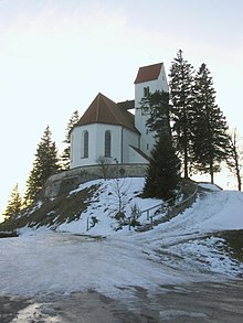
The mountain is a popular excursion destination because of the view of the Alps, especially from the St. George's Church on the summit .
geography
location
The Auerberg rises in the eastern part of the Allgäu on the border of the administrative districts of Upper Bavaria with the municipality of Bernbeuren and Swabia with the municipality of Stötten am Auerberg. Its summit and most of its high altitudes belong to Bernbeuren, whose core town is around 3 km east of the Schwanbach tributary Grönenbach (in the Lech catchment area). Its western flank is part of Stötten, whose core town is about 3.5 km west of the Wertach tributary, Geltnach .
The following farms and hamlets are located on the mountain: Eschach , Günther , Helmer , Hohenösch , Prachtsried and Sennhof in the municipal area of Bernbeuren and Buchen , Geisenhofen , Hofen , Pracht , Reinharden , Salchenried , Unterbuchen , Weghof and Winkel in the municipal area of Stötten.
The dome-shaped mountain exceeds the much better known Hohe Peißenberg ( 988 m ; also called Bayerischer Rigi ), 22 km to the north-east as the crow flies, by 67 m and is partially forested.
Up to high altitudes by the western slope, the draws conservation area Auerberg ( CDDA ; 1980 reported; 3,306 -No 395,805th square kilometers in size).
Natural allocation
The mountain is the central link in the natural area Auerberg (036.11) in the natural spatial main unit group Subalpines Jungmoränenland (No. 03), in the main unit Wertach-Lech-Jungmoränenland (036) and in the subunit Northeastern Wertach-Lech-Jungmoränenland (036.1).
history
The first traces of settlement around the Auerberg in the Neolithic Age (around 2500 years BC) have been documented since 1918 by the discovery of a stone ax in the village of Heggen. Around 1200 to 1000 BC A few Illyrians settled from the Balkans .
From the 8th century BC The immigrant Celts brought with them the new technology of salt mining and iron smelting and processing. They laid the foundation for a more intensive peasant economic culture and built the Damasia fortress, already mentioned by the Greek geographer Strabo , associated with the Auerberg and probably located there . After a decisive Celtic-Roman battle at the time of Drusus and Tiberius (from 15 BC), the region around the mountain was under Roman rule for the next few centuries.
In the first half of the 1st century AD, a military base including a civilian settlement is documented. In addition to various residential and commercial buildings, the remains of which can be proven in the archaeological findings, a large earth wall has been preserved that surrounds the two mountain tops of the Auerberg. There are also rich finds, some of which are imported items. Dendrochronological studies have shown that Roman settlement activities began no later than 13 AD. The summit region of the Auerberg was probably the oldest large-scale Roman settlement in Bavaria. About 5 km east of this, the Roman state road Via Claudia Augusta led along the wild mountain river Lech from the direction of Füssen past the mountain to the north into the Landsberg area , where it met the Roman road Cambodunum (Kempten) - Abodiacum near Epfach . After 40 AD, however, the Roman settlement was abandoned again. It is partially identified in research with the place Damasia ( Greek "Δαμασία"), which the Greek researcher Strabon names in his geographic handbook as a Celtic place in the foothills of the Alps and as "ὥσπερ ἀκρόπολις" ("like an acropolis ", so "like a towering / above city ").
Germanic Alemanni invasions in the period of mass migration led to widespread land grabbing and from the 6th and 7th centuries to develop a Celtic-Roman alemannisch-mixed population. At the same time, Christianity was gaining ground. The original parish of St. Georg on the Auerberg is likely to have originated around 800 AD.
The era of the Romans on the Auerberg is presented in an exhibition in the Auerberg Museum in Bernbeuren.
Events
The Georgiritt on the Auerberg takes place every year since 1925 on the Sunday after the name festival of St. Georg (April 23). First, a solemn field mass is celebrated with a horse blessing, then all riders, including the local priest on horseback, circle the St. George's Church on the summit in a splendid pageant.
The Auerberg Triathlon has been held every year since 2000 . The swimming route (1,500 m) is completed in the Haslacher See between Bernbeuren and the neighboring town of Burggen , the cycling route with a total distance of 42 km on a three-fold circuit between Burggen and the district of Dessau, and the final 10 km run in the municipality of Bernbeuren.
Since 2003, the Mtb Auerberg Marathon has been held every year on Mother's Day, i.e. on the second weekend in May, a mountain bike race that starts and ends in Kaufbeuren and has its turning point on the mountain. With a distance of about 63 km and a difference in altitude of 1070 meters, the race is a challenge for all ambitious mountain bikers and amateur cyclists.
Possibility of viewing
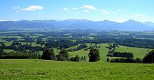
From the viewing platform on the roof of St. George's Church there is an Alpine panorama that extends from the Wendelstein in the east, over the Wetterstein Mountains , the Ammergau Alps to the Allgäu Alps and the Bregenz Forest in the west.
Others
The Auerberg is the namesake of the intermunicipal association Auerbergland , to which the communities around the mountain belong.
An adventure hotel on the Auerberg is currently being planned. In summer 2007 the old inn on the mountain was reopened. A citizens' initiative was founded against the original building plans, with the aim of preserving the historical cultural landscape. Citizens of Bernbeuren and the surrounding Auerbergland communities, monument protection authorities, nature conservation associations, politicians, the Bavarian State Ministry etc. support the initiative, which fears a massive change in the landscape at this outstanding location in the foothills of the Alps. Because of the heated discussions, the existing zoning and development plans were canceled by the municipality in October 2008.
In July 2008 the association of the "Interest Group Auerberg" was founded. Members of the initiative include a. also the well-known filmmaker and writer Doris Dörrie as well as guests from the Auerbergland from all over Germany.
Transport links and hiking
The 19 World Cup leads from Bernbeuren as a cul-de-sac on the Auerberg; At the end of this cul-de-sac through the Auerbergstraße on the eastern slope, there are parking spaces. A narrow municipal road branches off from this road before Höhenösch, which runs through Günther, Prachtsried, Reinharden / Geisenhofen, Buchen and Unterbuchen to Stötten. The road OAL 9 - WM 20 leads south past the mountain from Bernbeuren through Eschach, Salchenried, Pracht / Weghof and Hofen to Stötten.
The Munich Way of St. James runs about 200 m south of the summit .
literature
- Günter Ulbert : The Auerberg I. Topography, research history and wall excavations. (= Munich contributions to prehistory and early history 45). Beck, Munich 1994.
- Günter Ulbert, Werner Zanier : The Auerberg II. Settlement within the ramparts . (= Munich contributions to prehistory and early history 46). Beck, Munich 1997.
- Günter Ulbert: The Auerberg. A Roman mountain settlement from the early 1st century AD In: AkademieAktuell. Issue 3/2006, pp. 32–37 ( PDF ).
Individual evidence
- ↑ a b BayernAtlas of the Bavarian State Government ( notes )
- ↑ Map services of the Federal Agency for Nature Conservation ( information )
- ^ Hansjörg Dongus : Geographical land survey: The natural space units on sheet 188/194 Kaufbeuren / Mittenwald. Federal Institute for Regional Studies, Bad Godesberg 1993. → Online map (PDF; 6.4 MB)
- ↑ Strabo, Geography 4,6,8.
