
Bernbeuren
| coat of arms | Germany map | |
|---|---|---|

|
Coordinates: 47 ° 44 ' N , 10 ° 47' E |
|
| Basic data | ||
| State : | Bavaria | |
| Administrative region : | Upper Bavaria | |
| County : | Weilheim-Schongau | |
| Management Community : | Bernbeuren | |
| Height : | 773 m above sea level NHN | |
| Area : | 41.66 km 2 | |
| Residents: | 2416 (Dec. 31, 2019) | |
| Population density : | 58 inhabitants per km 2 | |
| Postal code : | 86975 | |
| Area code : | 08860 | |
| License plate : | WM, SOG | |
| Community key : | 09 1 90 114 | |
| LOCODE : | DE B6W | |
| Community structure: | 63 parts of the community | |
| Address of the municipal administration: |
Marktplatz 4 86975 Bernbeuren |
|
| Website : | ||
| First Mayor : | Karl Schleich (WLB) | |
| Location of the municipality of Bernbeuren in the Weilheim-Schongau district | ||
  |
||


Bernbeuren ( dialect : Bearabeira ) is the westernmost municipality in the Upper Bavarian district of Weilheim-Schongau . The community is a member of the Bernbeuren administrative community .
geography
The community is located in the Oberland region , at the eastern foot of the 1055 m high Auerberg . Bernbeuren is the westernmost municipality in the administrative region of Upper Bavaria.
Community structure
There are 63 officially named parts of the municipality (the type of settlement is given in brackets ):
|
|
|
|
There are the districts Auerberg, Bernbeuren and Echerschwang.
history
Until the church is planted
The place goes back to a settlement to which the Merovingian clan of Bero gave their name, but it was not until 1221 that an Ulrich von Beroburo was mentioned in a document. In the Carolingian era, a Frankish imperial court was set up in Bernbeuren . At the time of the Holy Roman Empire , Bernbeuren was part of the Augsburg monastery . On June 1, 1720, the place was almost completely destroyed by fire. The structure created by the reconstruction in the 18th century has largely been preserved. Since the Reichsdeputationshauptschluss of 1803 the place belongs to Bavaria. In the course of the administrative reforms in the Kingdom of Bavaria , today's municipality was created with the municipal edict of 1818 .
District affiliation
Bernbeuren belonged to the district of Schongau until June 30, 1972 , since then to the district of Weilheim i.OB, whose name was changed to the district of Weilheim-Schongau on May 1, 1973.
Incorporations
On May 1, 1978, parts of the area of the dissolved community of Tannenberg were incorporated.
Population development
Between 1988 and 2018 the municipality grew from 1,852 to 2,433 by 581 inhabitants or by 31.4%.
| year | 1840 | 1871 | 1900 | 1925 | 1939 | 1950 | 1961 | 1970 | 1987 | 1991 | 1995 | 2000 | 2005 | 2010 | 2015 |
| population | 1398 | 1490 | 1525 | 1650 | 1435 | 2125 | 1742 | 1748 | 1820 | 1966 | 2049 | 2176 | 2303 | 2288 | 2391 |
politics
Mayor and City Council
Karl Schleich of the Voting Community Lebendiges Bernbeuren (WLB) has been the mayor since May 2020. His predecessor in office from 2014 was Martin Hinterbrandner (Independent Voting Association; UWG).
Of the 14 seats in the municipal council, the UWG holds 10, the WLB 4.
tax income
The municipal tax revenue in 2013 amounted to the equivalent of € 1,510 thousand, of which the trade tax income (net) amounted to € 331 thousand.
Auerbergland
Bernbeuren is a member municipality of the intermunicipal alliance “ Auerbergland ”, which crosses the borders of the administrative districts of Swabia and Upper Bavaria .
coat of arms
|
|
Blazon : “Divided by red and silver; above a continuous silver cross, below a red three-mountain in the shield base. "
<all quotations> |
| Justification of the coat of arms: The cross, a symbol of St. George, refers to the patronage of the old pilgrimage church St. Georg on the over 1000 meter high Auerberg [...] The Dreiberg symbolizes the geographical location of the community on the Auerberg. The tinging in red and silver underlines the close historical connection to the Hochstift Augsburg; Bernbeuren used to belong to the Augsburg nursing office in Füssen. |
Culture and sights
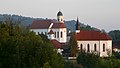
- Bernbeuren: Baroque parish church of St. Nicholas with the pilgrimage chapel of the Visitation of the Virgin Mary
- St. George's Church on the Auerberg
- Auerbergmuseum im Kiebelehaus 2011 with the themes “The Mountain - The Romans on the Auerberg”, “The Village - Bernbeuren, the History of the Community”, “The Land - The Agrarian Change from Blue to Green Allgäu ” and “The House - The Timber Construction , Roman strip house and Allgäu frame construction "
See also: List of architectural monuments in Bernbeuren and List of ground monuments in Bernbeuren

Auerberg in winter
Dreikirchenblick

Bernbeuren from the east
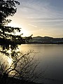
The Auerberg, in front of it the Haslacher See

Hohenösch am Auerberg

Kinsegger pond

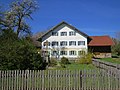
Lieblemüller, 18th century
At Ziegelheiß on the post


Economy and Infrastructure
Economy including agriculture and forestry
In 2013 there were six in the field of agriculture and forestry, 71 in the manufacturing sector and 105 in the trade, transport and hospitality sector, 22 in the corporate service provider sector and 53 in the public and private sector 53 employees at the place of work. There were a total of 924 employees at the place of residence subject to social security contributions. There were none in manufacturing, and in 2014 there were six companies in the construction industry. In addition, there were 101 farms in 2010 with an agriculturally used area of 2510 hectares, of which 2448 hectares were permanently green.
education
In 2014 the following institutions existed:
- Kindergartens: 135 kindergarten places with 100 children
- Elementary schools: one with four teachers and 89 students
Personalities
Prominent residents
- Doris Dörrie (* 1955) has her second home in Bernbeuren and is a member of the local museum association and IG Auerberg.
sons and daughters of the town
- Corinna Scholz (born August 1, 1989), European curling champion 2009 , curling world champion 2010
literature
- Working group “History” Bernbeuren (Ed.): Bernbeuren - From the history of our village . Bernbeuren 1995, ISBN 3-930599-06-6 .
Web links
- Homepage
- Auerbergmuseum in the Kiebelehaus Bernbeuren
- Bernbeuren: Official statistics of the LfStat (PDF; 1.24 MB)
Individual evidence
- ↑ "Data 2" sheet, Statistical Report A1200C 202041 Population of the municipalities, districts and administrative districts 1st quarter 2020 (population based on the 2011 census) ( help ).
- ↑ Mayor. Bernbeuren community, accessed on May 30, 2020 .
- ↑ Bernbeuren community in the local database of the Bavarian State Library Online . Bayerische Staatsbibliothek, accessed on September 5, 2019.
- ↑ Georg Paula , Stefanie Berg-Hobohm : District Weilheim-Schongau: Monuments in Bavaria. Lipp, Munich 2003, Volume 1, p. 26
- ↑ Bernbeuren municipality. In: The district of Weilheim-Schongau. Published by: District Office Weilheim-Schongau 2010, texts: Max Biller (district archivist), Helmut Schmidbauer (district home administrator), page 46 f
- ^ Federal Statistical Office (ed.): Historical municipality directory for the Federal Republic of Germany. Name, border and key number changes in municipalities, counties and administrative districts from May 27, 1970 to December 31, 1982 . W. Kohlhammer, Stuttgart / Mainz 1983, ISBN 3-17-003263-1 , p. 596 .
- ↑ a b c d Bernbeuren: Official statistics of the LfStat (PDF; 1.24 MB) Retrieved on June 20, 2016.
- ^ Entry on the coat of arms of Bernbeuren in the database of the House of Bavarian History

Cities: Penzberg | Schongau | Weilheim in Upper Bavaria
Markets: Peißenberg | Peiting
Other municipalities: Altenstadt (Upper Bavaria) | Antdorf | Bernbeuren | Bernried am Starnberger See | Böbing | Burggen | Eberfing | Eglfing | Habach | Hohenfurch | Hohenpeissenberg | Huglfing | Iffeldorf | Ingenried | Oberhausen (near Peißenberg) | Obersöchering | Pähl | Polling (near Weilheim) | Prem | Raisting | Rottenbuch | Schwabbruck | Schwabsoien | Seeshaupt | Sindelsdorf | Steingaden | Wessobrunn | Wielenbach | Wildsteig