
Schongau
| coat of arms | Germany map | |
|---|---|---|

|
Coordinates: 47 ° 49 ' N , 10 ° 54' E |
|
| Basic data | ||
| State : | Bavaria | |
| Administrative region : | Upper Bavaria | |
| County : | Weilheim-Schongau | |
| Height : | 710 m above sea level NHN | |
| Area : | 21.34 km 2 | |
| Residents: | 12,377 (Dec. 31, 2019) | |
| Population density : | 580 inhabitants per km 2 | |
| Postal code : | 86956 | |
| Area code : | 08861 | |
| License plate : | WM, SOG | |
| Community key : | 09 1 90 148 | |
| LOCODE : | DE SGU | |
| City structure: | 2 parts of the community | |
City administration address : |
Münzstrasse 1–3 86956 Schongau |
|
| Website : | ||
| Mayor : | Falk Sluyterman van Langeweyde ( SPD ) | |
| Location of the city of Schongau in the Weilheim-Schongau district | ||
  |
||


Schongau ( dialect : Schoa'ga ) is a city in the Upper Bavarian district of Weilheim-Schongau . The main part of the city lies on the west bank of the Lech in the Pfaffenwinkel . The well-preserved old town was built on a Lechberg and still has an almost completely preserved city wall. Schongau is the westernmost city in the administrative district of Upper Bavaria . A dialectal transition area between the Bavarian and Swabian language areas begins east of the Lech, where the so-called Lechrain dialect is spoken.
geography
location
The oval hill, which is surrounded by the old city wall, was surrounded by the Lech on both sides in earlier times and is therefore called the Lechumlaufberg. The core of the old town is located on this mountain. A newer development area is Schongau-West.
The city is a stop on the Romantic Road between Augsburg and Füssen and is therefore on the route of many tourists who go to the royal castles in Schwangau or the Wieskirche .
The municipality has two officially named parts of the municipality (the type of settlement is indicated in brackets ):
Neighboring communities
The market town of Peiting is located in the immediate vicinity of the city on the east side of the Lech. The district town of Weilheim in Upper Bavaria is approx. 25 km to the east. Down the Lech, also approx. 25 km away, is the large district town of Landsberg am Lech in the neighboring district. The villages of Hohenfurch , Kinsau , Apfeldorf and Birkland can be found in the vicinity north of the city . Rather to the west are the villages of Altenstadt (with the district Schwabniederhofen ), Schwabsoien (with the district Sachsenried) and Ingenried . In the direction of Füssen (approx. 35 km away) are the villages of Burggen and Bernbeuren . Approx. 25 km west of Schongau is Marktoberdorf , the district town of the Ostallgäu district , as well as the independent city of Kaufbeuren .
history
The origin of Schongau is the current Altenstadt , a large part of the residents moved only a few kilometers further in the 13th century to the settlement founded on the Lechumlaufberg on the Lech and took the place name with them. The hillside position was much easier to defend. The city of Schongau is very close to the former Roman road to Augsburg, the Via Claudia Augusta (47 AD) and owes its origin to the Romans. In the Middle Ages it was an important junction and trading center on the Verona – Augsburg – Nuremberg transport line and on the salt road from Berchtesgadener Land to the Allgäu.
The Alamannic populated Lechrain was to the 12th century under the rule of the Swabian Guelph . After Welf VI's death . In 1191, the Guelph property in Swabia fell to the Staufers by inheritance . Emperor Friedrich Barbarossa added this to the Hohenstaufen household. When the last Hohenstaufen ruler, Konradin, moved to Italy in 1267 to defend his claims to power against Karl von Anjou , his ally, Duke Ludwig II of Bavaria, unexpectedly withdrew his help and demanded the settlement of debts, which is why Konradin considered a large part of his property claims Duke of Swabia had to pledge (so-called Conradin donation). In this way, the Bavarian dukes from the Wittelsbach family , who endeavored to shift their sphere of influence into the Alemannic settlement area - up to the Lech - came into possession of most of the Lechrain in 1268.
Emperor Ludwig the Bavarian had given Schongau its own legal book with minting rights in 1331 . Duke Christoph the Strong liked to stay in the city, Christophstrasse in the old town is named after him. On May 22nd, 1493 a devastating fire destroyed large parts of the upper town and the ducal nursing home; Most of the reconstruction was not completed until 1514. Schongau was involved in armed conflicts several times and was often the place of transit or residence of friendly and hostile troops.

Through trade and the lively industry of its citizens, Schongau experienced a heyday until the discovery of America, which resulted in the relocation of the major trade routes. As a result, the city became so poor that important buildings such as the castle or the Ballenhaus partially collapsed or were dismantled because there was not enough money to renovate the roof.
Michel de Montaigne rode in 1580 with his retinue from Bordeaux ......... to Wangen, Isny, Kempten, Pfronten, Füssen, flowed over the Lech to Schongau, Landsberg, Augsburg - then rode over Munich, Innsbruck, towards Rome. He writes in the diary of Schongau, page 57: “After dinner we set out and some like the others came to Schongau for the night, four miles from it, a small town belonging to the Duke of Bavaria and consequently entirely Catholic: this prince has more than any other German kept his territory clean from the infection and remained incessantly with the old faith. The star is a good inn. Here we found a new arrangement of the table: the salt racks were placed on a square table from one corner to the opposite, so that a St. Andrew's cross was formed. ; We also got new wine, which is usually drunk there after the fermentation has ended ... ".
During the witch madness there was a witch trial in Schongau (1589–1592), which with 63 victims was one of the largest in southern Germany.
After the Second World War, the city and the surrounding area gained a significant number of inhabitants through refugees and, thanks to the prosperous middle class, developed into a district with relatively low unemployment.
The city had its first railway connection on November 16, 1886 through the Landsberg am Lech – Schongau railway line . The railway connection in the direction of Weilheim was opened on January 12, 1917 by the Schongau – Peißenberg railway line. Originally because of mining in Peiting , the Kaufbeuren – Schongau railway ran from 1923 to 1977 .
Schongau used to be the district town of a district of the same name . As a result of the Bavarian district reform in 1972, it merged with the Weilheim district to form today's Weilheim-Schongau district. There are still some district authority institutions in the city, and the name Altlandkreis Schongau is still used occasionally.
| year | Residents |
|---|---|
| 1840 | 1,555 |
| 1900 | 2,472 |
| 1939 | 3,647 |
| 1950 | 6,599 |
| 1961 | 8,832 |
| 1970 | 11.006 |
| 1987 | 10.182 |
| 1991 | 11,109 |
| 1995 | 11,731 |
| 2000 | 12,168 |
| 2005 | 12,449 |
| 2010 | 12,082 |
| 2010 (census) | 11,643 |
| 2015 | 12,291 |
From 1988 to 2018 the city grew from 10,351 to 12,396 by 2,045 inhabitants or 19.8%.
politics
City council
| Party / list | 2020 election | Election 2014 | 2008 election | Election 2002 | |||||
|---|---|---|---|---|---|---|---|---|---|
| % | Seats | % | Seats | % | Seats | % | Seats | ||
| CSU | 36.3 | 8th | 33.9 | 8th | 38.6 | 9 | 39.7 | 10 | |
| SPD | 25.3 | 6th | 29.4 | 7th | 33.0 | 8th | 33.6 | 8th | |
| Independent Voters Association Schongau | 15.5 | 4th | 18.3 | 4th | 20.8 | 5 | 21.3 | 5 | |
| Alternative list Schongau | 11.9 | 3 | - | - | - | - | - | - | |
| Green | 11.0 | 3 | - | - | - | - | - | - | |
| Alternative list Schongau / Greens | - | - | 18.4 | 5 | 7.6 | 2 | 5.4 | 1 | |
| total | 100 | 24 | 100 | 24 | 100 | 24 | 100 | 24 | |
| voter turnout | 53.6% | 57.3% | 61.1% | 64.2% | |||||
mayor
Since May 1, 2014, the then 44-year-old administrative lawyer Falk Sluyterman van Langeweyde has been the first mayor of Schongau. In the 2014 local elections , as a candidate for the SPD, he won the runoff election on March 30, 2014 with an extremely narrow margin of 50.3% or 32 votes.
The opposing candidate was the 27-year-old curative educator Tobias Kalbitzer, who ran for an “unorganized group of voters Karl-Heinz Rumgedisse”. The candidates of the CSU and the Independent Voters' Association Schongau were eliminated in the first ballot on March 16. Kalbitzer's success in the first ballot was - against the background of his unconventional appearance in the run-up to the election - the subject of nationwide reporting.
Kalbitzer also achieved a seat in the city council election on March 16, 2014 with the highest cumulative number of votes ever cast for a Schongau city council candidate of 5656 for the Schongau Alternative List (the local group associated with the Greens ).
On May 6, 2014, the city council elected Kalbitzer as second mayor with a 15-9 vote.
The first mayor's predecessor was Karl-Heinz Gerbl (SPD), who served from May 1, 2008 to April 30, 2014.
coat of arms
Blazon : "A black eagle with a red tongue in gold, the Bavarian diamonds on the breast shield." The city's coat of arms was awarded to the city in 1331 by Emperor Ludwig the Bavarian .
Town twinning
Schongau is one of a circle of four cities that have been linked by a partnership since 1962. The other three are:
Schongau also maintains other partnerships
-
 Abingdon-on-Thames , United Kingdom , since 1970
-
 Gogolin , Poland , since 1996
Attractions
- The old town of Schongau is an ensemble on the basis of the Monument Protection Act of October 1, 1973.
- The ground floor of the Ballenhaus used to be a storage room and cupboard for the flow of goods on the trade routes. The city administration was housed on the upper floors. Between 1858 and 1860, almost a third of the building was demolished due to damage.
- The parish church Mariae Himmelfahrt has a rococo interior with frescoes by Matthäus Günther and stucco from the Wessobrunn school .
- The city wall dates from the 14th century. It used to have five gates and sixteen towers.
- The police tower is a gate tower from the 13th century. It was built from tuff as a shell tower. After it had lost its function as a city gate, the open rear facing the city was closed and the tower was rebuilt as an inhabited entrance. In 1787 the octagon with a tent roof was put on. In the 19th century residential use by the police officer.
- In the mint building on the northern city wall, the right to mint was exercised until the middle of the 16th century. It was rebuilt in 1771.
- Schongau City Museum
See also: List of architectural monuments in Schongau and List of ground monuments in Schongau
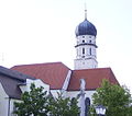
City parish church Mariae Himmelfahrt

Ballenhaus
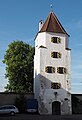
Police tower
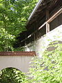
Part of the historic city wall

City wall with Maxtor

Mint with coin gate

Parish Church of the Transfiguration of Christ in Schongau-West


Economy and Infrastructure
traffic

Road traffic
Two federal highways crossed in Schongau, the B 472 comes from the direction of Bad Tölz and continues to Marktoberdorf , the B 17 reaches Schongau on its way from Augsburg to Füssen . Since 1997 these have been led around Schongau and Peiting to the west and south over the Lechtal bridge Schongau on a well-developed bypass road, mostly located on Schongauer Flur . The B 17 has become a mostly three-lane expressway between Landsberg am Lech and Schongau . H. with alternating overtaking options, expanded.
Rail transport
The Schongau railway station is the terminus of Pfaffenwinkel track that of Weilheim on Peissenberg and Peiting leads to Schongau. On this route, diesel multiple units of the Bavarian Regiobahn run every hour . Another functional rail connection exists in the direction of Landsberg am Lech (via Denklingen and Fuchstal ), on it only goods traffic takes place, which is handled by the Augsburg local railway . The initiative Fox Valley Railway e. V. is campaigning for a reactivation of passenger traffic on this route. Until the 1970s there was also a branch line to Kaufbeuren ( Kaufbeuren – Schongau railway ). Today, parts of the Sachsenrieder Bähnle and steam locomotive circuit run along a large section of the former route . Schongau used to have its own depot, the building was there until 1997.
Established businesses

Schongau was the trading and administrative center of the region until the 19th century. The castle (now part of the district office) and the still existing district court bear witness to this. Then it developed into an industrial city in the countryside. The company with the highest turnover is the paper manufacturer UPM-Kymmene (previously Haindl ), which has a supra-regional catchment area (southern Germany and neighboring countries) with the raw material recovered paper . The largest employer in town is the Hoerbiger company (industrial and vehicle components). Transport companies are also relatively well represented. There are also suppliers for the automotive industry (Hirschvogel Components GmbH, a subsidiary of the Hirschvogel Automotive Group ), textile production and services, etc. a. also for tourism.
education
Personalities
sons and daughters of the town
- Johannes Schlitpacher (1403–1482), monk, theologian, co-founder of the Melker Reform
- Hans Reichle (* approx. 1565–70; † 1642), sculptor and architect
- Johann Karl Kottmann (1776-1851), doctor
- Franz Jakob Anton Kottmann (1783–1844), painter and officer
- Franz Rupp (1901–1992), pianist
- Norbert Kugler (1906–1982), German resistance fighter
- Uwe Dick (* 1942), writer
- Reinhold Bocklet (* 1943), CSU politician
- Matthäus Schilcher (* 1947), geospatial scientist, geodesist and university professor
- Günther Sigl (* 1947), founding member, singer and bassist of the Spider Murphy Gang
- Luitpold Braun (* 1950), local politician and author
- Franz Dobler (* 1959), journalist and DJ
- Nikolaus "Niki" Schelle (* 1966), rally driver and television presenter
- Helmut Schleich (* 1967), cabaret artist
- Johannes Brantl (* 1968), theologian
- Christian Pfeiffer (* 1970), stunt, trial and enduro driver
- Andreas Loth (* 1972), ice hockey player
- Michael Kreitl (* 1975), ice hockey player
- Ulu Braun (* 1976), visual artist and filmmaker
- Steffi Volke (* 1976), long-distance runner
- Christian Veit (* 1980), professional snowboarder, junior world champion 1999, national team 1999–2007
- Stefan Schauer (* 1983), ice hockey player
- Christoph Melischko (* 1983), ice hockey player
- Christian Zippel (* 1984), philosopher, training theorist
- Josef Reßle (* 1986), jazz musician
- Simon Maier (* 1987), ice hockey player
- Bernhard Ebner (* 1990), ice hockey player
- Alex Roach (* 1993), ice hockey player
- Claus Pätzel , presiding judge at the Munich Higher Regional Court
Personalities who have worked in the city
- Heinrich Huber (1879–1916), church composer
- Fritz Dopfer (* 1987), alpine skiing
- Franz Josef Strauss (1915–1988), politician, district administrator of Schongau 1946–1948
literature
- History and monuments of the city of Schongau. First edition from 1852, reprint from 1969 by the publisher of the Schongauer Nachrichten.
- Yearbooks of the historical association Schongau with the name "Der Welf", since 1993.
- Joseph Friedrich Lentner: The Venetians in Schongau . Story by Joseph Friedrich Lentner (1814–1852). Ed .: Stadt Schongau (= historical series . Volume 6 ). Schongau 1993.
- M. Müller: Bibliography for Schongau and the surrounding area ( online )
- Edmund Kammel : Cyclist tour book for Weilheim taking into account the neighboring towns of Landsberg, Munich, Murnau, Schöngau and Tölz, Weilheim 1892, BSB Munich digital
- Historical novels from the hangman's daughter saga by Oliver Pötzsch (2008 - 2017 at Ullstein )
Web links
- Entry on the coat of arms of Schongau in the database of the House of Bavarian History
- Schongau: Official statistics of the LfStat (PDF; 1.24 MB)
Individual evidence
- ↑ "Data 2" sheet, Statistical Report A1200C 202041 Population of the municipalities, districts and administrative districts 1st quarter 2020 (population based on the 2011 census) ( help ).
- ^ Community of Schongau in the local database of the Bavarian State Library Online . Bayerische Staatsbibliothek, accessed on September 4, 2019.
- ↑ Jan Puhl: Death by the sword. In: spiegel.de . Spiegel Geschichte, August 27, 2010, accessed on March 19, 2014.
- ↑ a b Georg Paula, Stefanie Berg-Hobohm: District Weilheim-Schongau: Monuments in Bavaria. Volume 2, Lipp Verlag, Munich 2003, ISBN 3-87490-585-3 , p. 372.
- ^ A b Sigfrid Hofmann: History of the city of Schongau. In: Schongau, the heart of the Pfaffenwinkel. P. 46.
- ^ Anton Wilhelm Ertl : Chur-Bavarian Atlas . Nuremberg 1687, p. 159.
- ↑ File: Michel de Montaigne Italienreise.png
- ^ Municipal statistics from Schongau. (PDF; 1.06 MB). Retrieved October 23, 2010.
- ↑ City council election 2020, City of Schongau, official final result , accessed on June 8, 2020
- ^ Result of the 2014 local elections. In: merkur.de . Retrieved March 18, 2014.
- ↑ Weilheimer Tagblatt of March 18, 2014, local section p. 8.
- ^ Result of the 2008 local elections. In: wahlen.bayern.de . Retrieved May 23, 2011.
- ^ Result of the local elections in 2002. In: wahlen.bayern.de . Retrieved May 23, 2011.
- ↑ Mayoral election 2014 - final result. In: schongau.de. City of Schongau, accessed on May 1, 2014 .
- ↑ Tobias Kalbitzer. In: als-schongau.de. Schongau alternative list, accessed on March 31, 2014 .
- ↑ For example: Jochen Stahnke: Politics without pants. In: faz.net. Frankfurter Allgemeine Zeitung , March 28, 2014, accessed on March 31, 2014 .
- ↑ City council election 2014. In: schongau.de. City of Schongau, accessed on March 31, 2014 .
- ↑ Tobias Kalbitzer is Vice Mayor. In: merkur.de. Schongauer Nachrichten, May 7, 2014, accessed on May 7, 2014 .
- ^ Entry on the coat of arms of Schongau in the database of the House of Bavarian History
- ↑ City history & description of the coat of arms . In: schongau.de . City of Schongau, accessed on November 1, 2009.
- ^ A b Hans and Karl Pörnbacher: Schongau - gate to the Pfaffenwinkel. Kunstverlag Josef Fink, Lindenberg 2008, ISBN 978-3-89870-516-5 , p. 20.
- ^ A b Sigfrid Hofmann: A short history of the town of Schongau. In: Lech-Isar-Land. 1974, p. 149.
- ↑ Hans and Karl Pörnbacher: Schongau - gate to the Pfaffenwinkel. Kunstverlag Josef Fink, Lindenberg 2008, ISBN 978-3-89870-516-5 , p. 15 ff.
- ↑ Hans and Karl Pörnbacher: Schongau - gate to the Pfaffenwinkel. Kunstverlag Josef Fink, Lindenberg 2008, ISBN 978-3-89870-516-5 , p. 26.
- ↑ Sign with inscription on the tower.
- ↑ Peter Rasch: The branch lines between Ammersee, Lech and Wertach. With the Ammerseebahn, Pfaffenwinkelbahn & Co around the Bavarian Rigi . EOS Verlag, St. Ottilien 2011, ISBN 978-3-8306-7455-9 , pp. 212-215.
- ↑ The Bw Schongau. In: Eisenbahn Journal Issue 6/1985 of September, ISSN 0720-051X , Publisher: H. Merker, p. 36 ff.

Cities: Penzberg | Schongau | Weilheim in Upper Bavaria
Markets: Peißenberg | Peiting
Other municipalities: Altenstadt (Upper Bavaria) | Antdorf | Bernbeuren | Bernried am Starnberger See | Böbing | Burggen | Eberfing | Eglfing | Habach | Hohenfurch | Hohenpeissenberg | Huglfing | Iffeldorf | Ingenried | Oberhausen (near Peißenberg) | Obersöchering | Pähl | Polling (near Weilheim) | Prem | Raisting | Rottenbuch | Schwabbruck | Schwabsoien | Seeshaupt | Sindelsdorf | Steingaden | Wessobrunn | Wielenbach | Wildsteig