
Altenstadt (Upper Bavaria)
| coat of arms | Germany map | |
|---|---|---|
.svg)
|
Coordinates: 47 ° 49 ' N , 10 ° 52' E |
|
| Basic data | ||
| State : | Bavaria | |
| Administrative region : | Upper Bavaria | |
| County : | Weilheim-Schongau | |
| Management Community : | Altenstadt (Upper Bavaria) | |
| Height : | 722 m above sea level NHN | |
| Area : | 18.66 km 2 | |
| Residents: | 3305 (Dec. 31, 2019) | |
| Population density : | 177 inhabitants per km 2 | |
| Postal code : | 86972 | |
| Area code : | 08861 | |
| License plate : | WM, SOG | |
| Community key : | 09 1 90 111 | |
| LOCODE : | DE AWT | |
| Community structure: | 2 parts of the community | |
| Address of the municipal administration: |
Marienplatz 2 86972 Altenstadt |
|
| Website : | ||
| First Mayor : | Andreas Kögl (CSU) | |
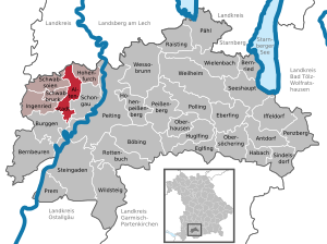
| Location of the municipality Altenstadt in the district of Weilheim-Schongau | ||
  |
||


Altenstadt is a municipality in the Upper Bavarian district of Weilheim-Schongau and the seat of the Altenstadt administrative community .
geography
The municipality is located in the Oberland region in Pfaffenwinkel , about 60 km southwest of Munich and 20 km southeast of Kaufbeuren .
The municipality has two officially named parts of the municipality (the type of settlement is indicated in brackets ):
- Altenstadt ( parish village )
- Schwabniederhofen ( Kirchdorf )
history
Until the church is planted
Around 15 BC the Roman Empire conquered the area during the Alpine campaigns in a battle between Rauhenlechsberg and Dießen against the Likatier . Altenstadt lies at the intersection of two old Roman roads, the Via Claudia Augusta and the old salt road from Kempten to Salzburg . In the area of today's Altenstadt, the Romans built a supply warehouse and named it "Esconova". The name of the camp is not scientifically proven.
Altenstadt is the former Schongau - in the 13th century a large part of the residents moved only a few kilometers further to the settlement on the Lech, which was founded on the Lechumlaufberg, and took the place name with them. The old settlement was simply called Altenstadt, the old town of Schongau.
Around the middle of the 12th century, the former castle, Burklaberg Castle of the Lechrainer Welfen on the Burglach, also called Schlossberg, was built. This castle no longer exists today. Altenstadt belonged to the Munich Rent Office and the Schongau Regional Court of the Electorate of Bavaria . In 1818 the political municipality was established.
20th century
After the end of World War II in 1945 , Altenstadt belonged to the American zone of occupation . The American military administration set up a DP camp to accommodate so-called displaced persons . Most of them were from Poland . The camp was looked after by UNRRA and dissolved in 1950 .
Incorporations
On May 1, 1978, the previously independent municipality of Schwabniederhofen was incorporated.
Population development
Between 1988 and 2018 the municipality grew from 2,920 to 3,319 by 399 inhabitants or 13.7%.
| year | 1840 | 1871 | 1900 | 1925 | 1939 | 1950 | 1961 | 1970 | 1987 | 1991 | 1995 | 2000 | 2005 | 2010 | 2015 |
| population | 598 | 659 | 763 | 897 | 1142 | 2938 | 2510 | 2522 | 2870 | 3059 | 3112 | 3195 | 3319 | 3279 | 3330 |
politics

Municipal council
| Party / list | 2020 election | Election 2014 | 2008 election |
|---|---|---|---|
| Seats | Seats | Seats | |
| CSU | 7th | 7th | 7th |
| SPD | 2 | 2 | 2 |
| UWV / FW | 5 | 5 | 5 |
| Schwabniederhofen voter community | 2 | 2 | 2 |
| Total seats | 16 | 16 | 16 |
mayor
Andreas Kögl (CSU) has been mayor of Altenstadt since May 2020. His predecessor was Albert Hadersbeck, who held the office for 18 years.
Council taxes
The municipal tax revenue in 2008 was € 2,262,000, of which € 538,000 (net) was trade tax revenue .
Culture and sights
Architectural monuments

The Romanesque basilica of St. Michael is significant with remains of medieval wall paintings and several examples of Romanesque sculpture. The basilica was preserved in its Romanesque form, because after the resettlement of most of the residents, the people of Altenstadt lacked the money for extensive renovations. In 1965 the church was given the title of papal minor basilica . Worth mentioning are inside the basilica
- The Romanesque baptismal font
- The triumphal cross group dated approx. 1210/20 . The larger than life crucifix "Great God of Altenstadt" is an original. The assistant figures Maria and Johannes, however, are copies, as the originals were sold to the Bavarian National Museum in 1867 to finance a church renovation and are exhibited there.
Museums
traffic
Between Altenstadt and Schongau, federal highway 17 runs from the north, pivoting slightly westwards to the south, in an open low-lying area, on its west side is the eastern municipality border. Altenstadt is connected here via the Schongau-West / Altenstadt exit, which is part of the plan . Altenstadt is connected to Schongau by four road bridges and a pedestrian / cycle path bridge via the road cut . Over one of these bridges, the state road St 2014 leads from the northwest from Kaufbeuren via Osterzell north past the center of Altenstadt, further east via Schongau and then right of the Lech north via Birkland to Apfeldorf . From north to south, the district road WM 6 , coming from Hohenfurch through the district Schwabniederhofen, crosses Altenstadt, which crosses the federal highway 472 south of the town and leads to Burggen . In addition, a community road leads west to Schwabbruck .
From 1923 there was a train station in Altenstadt on the Kaufbeuren – Schongau line . 1972 the passenger traffic and 1992 the freight traffic was stopped and the line was closed. In 2013, the Sachsenrieder Bähnle themed cycle path was opened, which leads largely on the former branch route from Schongau to Kaufbeuren.
Others
In the Old City which is Franz Josef Strauss - barracks (also the altenstadt air base ), in which airborne and air transport school that 2./FA/UA Btl.3 and sports promotion group of the Bundeswehr are.
In 1944 the Staeble factory (lens manufacturer) was relocated to Altenstadt (Südliche Römerstrasse). The Staeble works were later integrated into the Agfa group.
Web links
- Homepage
- Entry on the coat of arms of Altenstadt (Upper Bavaria) in the database of the House of Bavarian History
- Altenstadt (Upper Bavaria): Official statistics of the LfStat (PDF; 1.24 MB)
Individual evidence
- ↑ "Data 2" sheet, Statistical Report A1200C 202041 Population of the municipalities, districts and administrative districts 1st quarter 2020 (population based on the 2011 census) ( help ).
- ↑ Altenstadt municipality: town hall. Greetings. Retrieved May 14, 2020 .
- ^ Community Altenstadt in the local database of the Bavarian State Library Online . Bayerische Staatsbibliothek, accessed on September 5, 2019.
- ↑ History and Memories of the City of Schongau , first edition from 1852, reprint from 1969 by the publishing house of Schongauer Nachrichten, page 2
- ↑ a b Altenstadt. In: The district of Weilheim-Schongau. Published by: District Office Weilheim-Schongau 2010, texts: Max Biller (district archivist), Helmut Schmidbauer (district home administrator), page 44
- ↑ Peiting and Schongau (Altenstadt) under the Welfs (1050–1200) , Historical Association of and for Upper Bavaria, Munich 1920, page 17 ff
- ^ Federal Statistical Office (ed.): Historical municipality directory for the Federal Republic of Germany. Name, border and key number changes in municipalities, counties and administrative districts from May 27, 1970 to December 31, 1982 . W. Kohlhammer, Stuttgart / Mainz 1983, ISBN 3-17-003263-1 , p. 595 .
- ↑ a b Altenstadt municipal statistics , accessed on November 4, 2010
- ^ Result of the 2014 local elections , accessed on March 18, 2014
- ↑ Weilheimer Tagblatt of March 18, 2014, local section p. 8

Cities: Penzberg | Schongau | Weilheim in Upper Bavaria
Markets: Peißenberg | Peiting
Other municipalities: Altenstadt (Upper Bavaria) | Antdorf | Bernbeuren | Bernried am Starnberger See | Böbing | Burggen | Eberfing | Eglfing | Habach | Hohenfurch | Hohenpeissenberg | Huglfing | Iffeldorf | Ingenried | Oberhausen (near Peißenberg) | Obersöchering | Pähl | Polling (near Weilheim) | Prem | Raisting | Rottenbuch | Schwabbruck | Schwabsoien | Seeshaupt | Sindelsdorf | Steingaden | Wessobrunn | Wielenbach | Wildsteig