
Wildsteig
| coat of arms | Germany map | |
|---|---|---|

|
Coordinates: 47 ° 42 ' N , 10 ° 57' E |
|
| Basic data | ||
| State : | Bavaria | |
| Administrative region : | Upper Bavaria | |
| County : | Weilheim-Schongau | |
| Management Community : | Steingaden | |
| Height : | 882 m above sea level NHN | |
| Area : | 47.66 km 2 | |
| Residents: | 1310 (Dec. 31, 2019) | |
| Population density : | 27 inhabitants per km 2 | |
| Postal code : | 82409 | |
| Area code : | 08867 | |
| License plate : | WM, SOG | |
| Community key : | 09 1 90 160 | |
| LOCODE : | DE WG4 | |
| Community structure: | 19 parts of the community | |
| Address of the municipal administration: |
Kirchbergstrasse 20a 82409 Wildsteig |
|
| Website : | ||
| Mayor : | Josef Taffertshofer | |
| Location of the community Wildsteig in the district of Weilheim-Schongau | ||
  |
||

Wildsteig is a municipality in the Upper Bavarian district of Weilheim-Schongau and a member of the Steingaden administrative community .
geography
The community is located on the " Romantic Road " near the famous Wieskirche . At around 900 meters above sea level, Wildsteig is the highest municipality in the Weilheim-Schongau district . The Illach river has its source in the municipality .
Congregation structure
The municipal administration of Wildsteig is located on the Kirchberg.
The municipality has 19 officially named municipal parts (the type of settlement is given in brackets ):
|
|
history
Until the church is planted
The area of today's community Wildsteig was part of the closed Hofmark of the Rottenbuch monastery until secularization in 1803 . Wildsteig became an independent political municipality in the course of the administrative reforms in the Kingdom of Bavaria in 1818 and belonged to the Schongau district court .
Population development
Between 1988 and 2018, the municipality grew from 1,054 to 1,280 by 226 inhabitants or 21.4%.
| year | 1840 | 1871 | 1900 | 1925 | 1939 | 1950 | 1961 | 1970 | 1987 | 1991 | 1995 | 2000 | 2005 | 2010 | 2015 |
| population | 603 | 690 | 679 | 744 | 762 | 1063 | 815 | 882 | 1024 | 1105 | 1154 | 1232 | 1232 | 1254 | 1338 |
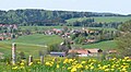
Wildsteig from the south
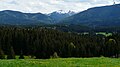
View from the Eckberg to the Laubeneck


Buildings
Parish church of St. Jakob from the second half of the 18th century (latest Rococo with classicist echoes) with high altar figures by the master of the Blutenburg apostles from the second half of the 15th century
See also: List of architectural monuments in Wildsteig and List of ground monuments in Wildsteig

Natural monuments
In the Ammerschlucht gorge on the border with the neighboring municipality of Bad Bayersoien are the Schleierfälle , which are formed by a brook falling down the Hanhgkante.
Personalities
- Hans Mangold (* 1952 in Wildsteig), specialist in internal medicine and politician (ÖDP and Greens).
Web links
- Entry on the Wildsteig coat of arms in the database of the House of Bavarian History
- Wildsteig: Official statistics of the LfStat (PDF; 1.24 MB)
- St. Jakob bells: https://www.youtube.com/watch?v=VTa1LDUqbAg
Individual evidence
- ↑ "Data 2" sheet, Statistical Report A1200C 202041 Population of the municipalities, districts and administrative districts 1st quarter 2020 (population based on the 2011 census) ( help ).
- ^ Community Wildsteig in the local database of the Bavarian State Library Online . Bayerische Staatsbibliothek, accessed on September 4, 2019.
- ↑ Steingaden municipal statistics , accessed on November 5, 2010

Cities: Penzberg | Schongau | Weilheim in Upper Bavaria
Markets: Peißenberg | Peiting
Other municipalities: Altenstadt (Upper Bavaria) | Antdorf | Bernbeuren | Bernried am Starnberger See | Böbing | Burggen | Eberfing | Eglfing | Habach | Hohenfurch | Hohenpeissenberg | Huglfing | Iffeldorf | Ingenried | Oberhausen (near Peißenberg) | Obersöchering | Pähl | Polling (near Weilheim) | Prem | Raisting | Rottenbuch | Schwabbruck | Schwabsoien | Seeshaupt | Sindelsdorf | Steingaden | Wessobrunn | Wielenbach | Wildsteig