
Bad Bayersoien
| coat of arms | Germany map | |
|---|---|---|

|
Coordinates: 47 ° 41 ′ N , 11 ° 0 ′ E |
|
| Basic data | ||
| State : | Bavaria | |
| Administrative region : | Upper Bavaria | |
| County : | Garmisch-Partenkirchen | |
| Management Community : | Saulgrub | |
| Height : | 812 m above sea level NHN | |
| Area : | 17.67 km 2 | |
| Residents: | 1221 (Dec. 31, 2019) | |
| Population density : | 69 inhabitants per km 2 | |
| Postal code : | 82435 | |
| Area code : | 08845 | |
| License plate : | Cap | |
| Community key : | 09 1 80 113 | |
| Community structure: | 8 parts of the community | |
| Association administration address: | Kohlgruber Str. 2 82442 Saulgrub |
|
| Website : | ||
| First Mayor : | Gisela Kieweg (For Bad Bayersoien) | |
| Location of the municipality of Bad Bayersoien in the Garmisch-Partenkirchen district | ||
  |
||


Bad Bayersoien is a municipality in the Upper Bavarian district of Garmisch-Partenkirchen and a member of the Saulgrub administrative community . The place is a spa and moor spa .
geography
The municipality is located in the Bavarian Oberland region . The Ammergau Alps Nature Park is nearby . The community is located on Lake Bayersoien .
Only the Bad Bayersoien district exists . There are eight officially named parts of the municipality (the type of settlement is given in brackets ):
|
|
history
Until the church is planted
The first written documentary mentions can be found about individual farms in today's municipal area in the 13th century. When the Marienstiftes in Ettal ("ètal") was founded in 1330 by Emperor Ludwig the Bavarian, the emperor transferred the imperial estates in the "Ammergau district" to the monastery - including more than half of the farms that existed in "Soyen" at that time. The farmers of the entire Ammergau, however, had to pay the monastery, in addition to other taxes, a forced labor (“gentleman's service”) in the form of harvesting work to bring the hay. For this work, the farmers of the respective places and hamlets were grouped together for the "Hofmahd".
At the same time as Ettal was founded, Oberammergau was given the so-called “Stapel” and “Rottrecht”, with which the Via Imperii, based on the Roman road Via Raetia , between the Lech ( Schongau ) and the Loisach Valley ( Partenkirchen ) was placed on the route via Ettal . Located on this “Rottstrasse”, “Soyen” became an up-and-coming place for the service industry of that time. Many of the rural properties belonging to the Ettal monastery in the village were reduced in size ("salvaged"), as craftsmen only needed the smaller farms that were created in this way for their own basic supplies. Most of their properties were built along the thoroughfare, creating an almost ideal-typical street village. The architectural character of this street village, with the gables of the houses facing the street, dominates the image of the central village street to this day.
With the secularization of 1803, the properties of the monasteries Ettal and Rottenbuch, which are located in today's municipality, became the property of the state, whereby the new Kingdom of Bavaria was very keen that the subjects acquired this state property for sale.
In the course of the administrative reforms in the Kingdom of Bavaria, the municipality edict of 1818 created today's municipality, which belonged to the royal district court of Schongau . Since in this context in the area of the royal. District court now two "Soyen" were, to differentiate that "Schwabseits" of the Lech lying Soyen to Schwabsoien, while the village lying on the Ammer is allowed to demonstrate its affiliation to (Upper) Bavaria.
20th century
In 1968 Bayersoien became a climatic health resort and in 1996 a health spa .
21st century
The village received more media attention in 2001 when a murder occurred in the municipality on the night of November 6th. The identity of the female victim remained unknown for more than two years; the specially founded “Soko Soien” was only able to identify her in 2004, despite several public searches (including unsolved in file number XY ). In 2011 it was possible to prove the murder of the then life partner of the victim. The case was thematized in episode 3 of the 2nd season of the crime series "Unsolved murders - the perpetrator on the trail".
Population development
Between 1988 and 2018 the municipality grew from 999 to 1,188 by 189 inhabitants or by 18.9%.

- 1961: 788 inhabitants
- 1970: 818 inhabitants
- 1987: 993 inhabitants
- 1991: 1042 inhabitants
- 1995: 1129 inhabitants
- 2000: 1137 inhabitants
- 2005: 1194 inhabitants
- 2010: 1164 inhabitants
- 2015: 1186 inhabitants
politics
Municipal council
In the local elections in 2014 , the 2008 from reaching boy electoral association / Fresh wind and Independent Voters Association Wählvereingung formed together for our village (GUD) 58% and seven seats (2008 to 2014, it had nine seats). The free Soier voter list of applicants, newly established in 2008 , came to 42% and has therefore had five members on the municipal council since 2014 (previously three members).
mayor
Mayor is Gisela Kieweg (no list). In 2014 she succeeded Eberhard Steiner (Young Voter Association / Fresh Wind).
Community finances
The municipal tax revenue amounted to € 744,000 in 2011, of which the trade tax revenue (net) amounted to € 125,000.
coat of arms
The arms description reads: In the golden Blue crookedness of Abtstabs via a covered silver wooden bridge with two silver wave bar between the abutments.
The municipal flag is yellow, blue and white, with the coat of arms in the middle.
Attractions
Buildings
The parish church of St. George was built during the 15th or 16th century and was rebuilt and expanded in Baroque style in 1717. The 183 m long Echelsbacher Bridge was completed in 1929 for 900,000 RM construction costs and, with a 130 m arch span, it was the widest- spanned Melan arch bridge in the world. She gained macabre notoriety through the many suicides . In 2018, a makeshift bridge was built right next to the Echelsbach Bridge, it was closed and its supporting structure and roadway removed. Work is currently underway on a new bridge, whereby only the arch of the old structure remains, but only as a monument without the static load-bearing function of the new bridge. The costs for this are estimated at EUR 17.4 million and completion is planned for mid-2021.
See also: List of architectural monuments in Bad Bayersoien and List of ground monuments in Bad Bayersoien
Museums
The "Museum im Bierlinghaus" with its extensive collection and changing special exhibitions is well worth seeing. The "Bierlings" were a merchant family from Bayersoien and the local family for more than 25o years. You had the office of the salt factor, an officially appointed administrator of the salt dumps in which the salt transported on the Rottstrasse was stored. The museum shows how they lived and lived. The museum also deals with the old handicrafts and peat extraction in the moss.
The “Lötschmüllerhof” was another museum in Bad Bayersoien. For more than 30 years, the owner of the Lötschmüllerhof collected rarities from over 150 years. The special thing about the museum was an underground connecting passage between the two lakes, which in the past probably served as a cesspool with water flushing. The Lötschmüllerhof burned down on September 2, 2017.
Others
Bad Bayersoien is located on Rottstrasse, a former very important European long-distance trade route from Augsburg to Venice. On the Dorfstraße you can find the Rottstein, which reminds of the Rott privilege of Emperor Ludwig of Bavaria from 1332.
The moor lake Bayersoiener See is located in Bad Bayersoien . It is considered to be one of the warmest bathing lakes in southern Bavaria. A nature trail leads around the lake.
In the Ammerschlucht gorge on the border to the neighboring community of Wildsteig are the Schleierfälle , which are formed by a brook cascading down the slope edge.
Economy and Infrastructure
Economy including agriculture and forestry
In 2011 there were a total of 214 employees subject to social security contributions at the place of work. There were no employees in the agriculture and forestry sector, 57 in the manufacturing sector, 115 in the trade and transport sector, eleven in the corporate service sector and 31 in the public and private service sector 31. There were a total of 396 employees at the place of residence subject to social security contributions. In the manufacturing industry there were no companies with more than 20 employees, in the main construction industry there were five companies with 24 employees.
In addition, in 2010 there were 35 farms with an agricultural area of 738 hectares.
traffic
The federal highway 23 , which leads from Peiting via Garmisch-Partenkirchen to the Austrian border near Ehrwald , leads around the village . The road is part of the German Alpine Road near Bad Bayersoien and crosses the Ammer at the municipality border with Rottenbuch with the Echelsbacher Bridge . The place is connected to the bus network of the RVO via line 9606 from Garmisch-Partenkirchen to Füssen .
education
In 2012 the following institutions existed:
- Kindergartens: 50 kindergarten places with 28 children
- Elementary schools: one with four teachers and 28 students
tourism
The municipality of Bad Bayersoien is part of the Ammergau Alps tourist region . The region is represented in terms of tourism by the Ammergauer Alpen GmbH. In addition to Bad Bayersoien, the Ammergau Alps nature park region includes the villages of Unterammergau , Oberammergau , Bad Kohlgrub , Ettal / Graswang / Linderhof and Saulgrub / Altenau / Wurmansau.
In 2018, Bad Bayersoien generated around 101,000 overnight stays and 21,500 arrivals.
Personalities
Sons and daughters of the church
- Othmar Weis (1770–1843), Benedictine priest, author of the Oberammergau Passion Play
- Adelheid Reichsiegel (1931-2018), "the painting farmer from the Balteshof"
- Hans Matthäus Bachmayer (1940–2013), sculptor, painter, philosopher
People who worked on site
- Imme Hoefer-Purkhold (1919–2008), sculptor and graphic artist in Bad Bayersoien
- Walter Richard Kahn (1911–2009), travel operator, died in Bad Bayersoien
- Franz Mörscher (1931–2018), sculptor, mosaic artist, painter, photographer and non-fiction author lived and worked in Bad Bayersoien
- Joseph Schmuzer (1683–1752), builder of the parish church of St. Georg in Bad Bayersoien
- Isolde Holderied (* 1966), rally driver, grew up in Bad Bayersoien and lives there

Maypole and parish church

The parish church of St. George

Street
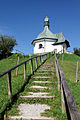
War memorial chapel


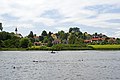
View over the Soiener See to Bad Bayersoien

View over the Soiener See to the western area

On the shore of the Soiener See

Soiener See with Hörnle


Web links
- Homepage of the Bad Bayersoien community
- Bad Bayersoien (Ammergau Alps tourism portal)
- Entry on the coat of arms of Bad Bayersoien in the database of the House of Bavarian History
Individual evidence
- ↑ "Data 2" sheet, Statistical Report A1200C 202041 Population of the municipalities, districts and administrative districts 1st quarter 2020 (population based on the 2011 census) ( help ).
- ^ Municipality of Bad Bayersoien: Municipal Council. Retrieved May 23, 2020 .
- ^ Community of Bad Bayersoien in the local database of the Bavarian State Library Online . Bayerische Staatsbibliothek, accessed on September 6, 2019.
- ↑ The Lansman Files: Terrible Murder ten years ago in the Ammertal. November 4, 2011, accessed February 18, 2019 .
- ↑ imfernsehen GmbH & Co KG: Unsolved murders - On the trail of the perpetrator Season 2, episode 3: Zeljka and the ice-cold killer / Soko Soien and the murder plot. Retrieved February 18, 2019 .
- ^ Bayerischer Rundfunk Lui Knoll: Echelsbacher Bridge: Germany's largest temporary bridge is opened . June 22, 2018 ( br.de [accessed on August 21, 2019]).
- ↑ Flame hell at Lötschmüller: Large-scale operation at night in Bad Bayersoien. September 3, 2017, accessed April 18, 2019 .
- ↑ a b Bavarian State Office for Statistics and Data Processing - Municipal Statistics 2012: Bad Bayersoien (PDF file; 1.67 MB)
- ↑ Regional traffic Upper Bavaria - Timetable line 9606 ( Memento of the original from December 15, 2017 in the Internet Archive ) Info: The archive link was inserted automatically and has not yet been checked. Please check the original and archive link according to the instructions and then remove this notice. (PDF; 0.1 MB)

Bad Bayersoien | Bad Kohlgrub | Eschenlohe | Ettal | Farchant | Garmisch-Partenkirchen | Grainau | Großweil | Krün | Mittenwald | Murnau am Staffelsee | Oberammergau | Oberau | Ohlstadt | Riegsee | Saulgrub | Schwaigen | Seehausen am Staffelsee | Sparrow House | Uffing am Staffelsee | Unterammergau | Wallgau
Unregulated areas: Ettaler Forst