Saulgrub
| coat of arms | Germany map | |
|---|---|---|

|
Coordinates: 47 ° 40 ' N , 11 ° 2' E |
|
| Basic data | ||
| State : | Bavaria | |
| Administrative region : | Upper Bavaria | |
| County : | Garmisch-Partenkirchen | |
| Management Community : | Saulgrub | |
| Height : | 859 m above sea level NHN | |
| Area : | 35.48 km 2 | |
| Residents: | 1657 (Dec. 31, 2019) | |
| Population density : | 47 inhabitants per km 2 | |
| Postal code : | 82442 | |
| Area code : | 08845 | |
| License plate : | Cap | |
| Community key : | 09 1 80 129 | |
| Community structure: | 6 parts of the community | |
| Address of the municipal administration: |
Kohlgruber Str. 2 82442 Saulgrub |
|
| Website : | ||
| Mayor : | Rupert Speer ( community of voters ) | |
| Location of the municipality of Saulgrub in the Garmisch-Partenkirchen district | ||
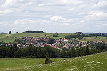
Saulgrub is a municipality in the Upper Bavarian district of Garmisch-Partenkirchen and, together with the Bad Bayersoien municipality, forms the Saulgrub administrative community .
geography
Saulgrub is located in the Oberland region and in the Ammergau Alps Nature Park .
Community structure
The municipality has six officially named municipality parts :
- Achele ( hamlet )
- Altenau ( parish village )
- Saulgrub ( Kirchdorf )
- Saulgruber mill ( wasteland )
- Unterogg (wasteland)
- Wurmansau ( village )
The Saulgrub and Unterammergauer Forst districts exist .
history
Until the church is planted
Saulgrub, then called sulgrain , was first mentioned in a document in 1280. It belonged to Ettal Abbey for a long time until the secularization in 1803 . Saulgrub was part of the Murnau ruling court of the former imperial monastery. The landlord was partly the Ettal Abbey and partly the Rottenbuch Abbey .
In the course of the administrative reforms in the Kingdom of Bavaria , the municipality edict of 1818 created today's municipality, which belonged to the Schongau district court .
19th century
In 1840 a village chronicle reported about a castle that had stood near the "Obermoosfilz" and the remains of the wall were used by the Saulgrubers to build their houses.
At the end of the 19th century, an Etruscan bronze helmet from the 6th century BC was found in Saulgrub . There is also evidence that the Via Imperii (Rottstrasse from Augsburg to Verona) ran through what is now the local area.
Population development
Between 1988 and 2018 the municipality grew from 1,455 to 1,642 by 187 inhabitants or by 12.9%.
- 1840: 401 inhabitants
- 1900: 595 inhabitants
- 1950: 1171 inhabitants
- 1987: 1469 inhabitants
- 1991: 1458 inhabitants
- 1995: 1535 inhabitants
- 2000: 1618 inhabitants
- 2005: 1687 inhabitants
- 2010: 1648 inhabitants
- 2015: 1640 inhabitants
politics
mayor
Mayor is Rupert Speer (community of voters), he succeeded Michael Mangold junior in 2008. and re-elected in 2014.
Municipal council
The municipal council has twelve members and the mayor, all of whom are active in the electoral community.
tax income
The municipal tax revenue in 2014 was € 1.034 million, of which € 225,000 (net) was trade tax. Saulgrub has been debt-free since 2010.
coat of arms
The description of the coat of arms reads: Under a shield head in silver, divided by silver and blue, a growing red griffin lion
Attractions
Buildings
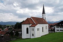
- The most prominent building in Saulgrub itself is the St. Franziskus Church, which is located on a hill above the village .
- Several farmhouses and barns, some with elaborate wood carvings, as well as the Saulgrub train station are under monument protection.
- The Fatima Chapel , which was built in 1954 after a vow, is located on a hill near the whetstone ridge .
- Another sacred building worth seeing, the St. Anton Church , is the center of the Altenau district.
- The St. Josef Chapel is in Wurmansau .
- The Hubertus Chapel is located in the forest along the Halbammer south of Unterstogg .
- The Kammerl power plant on the Ammer , built in 1898/99, is the world's oldest railway power plant for single-phase alternating current.
nature
- The Scheibum , a rock breakthrough of the Ammer, is in the immediate vicinity of the Kammerl power station . From there the river flows through the Ammerleite , a gorge that is only accessible by canoe.
- The Altenauer Moor lies between Saulgrub and Altenau. It is a raised bog and is still open at its highest point. The deep sea can be reached from the Naturfreundehaus in Saulgrub through a felt felt. The hiker is safely guided over a path paved with wooden beams.
Economy and Infrastructure
Economy including agriculture and forestry
In 2011 there were no employees in agriculture and forestry or in trade and transport, and 189 in the manufacturing sector at work. In other economic sectors this value was 132. There were 618 employees subject to social security contributions at the place of residence. There was one company in manufacturing and six in construction.
In addition, in 2010 there were 29 farms with an agricultural area of 702 ha.
traffic
Saulgrub is connected to the Deutsche Bahn network with a stop on the Ammergaubahn . Trains stop there every hour in the direction of Oberammergau or Murnau am Staffelsee. In addition, the RVO bus route 9606 runs through the town.
The place is bypassed in the east by the federal highway 23 from Peiting to Garmisch-Partenkirchen . Until 2016 it led through the place.
education
In 2012 the following institutions existed:
- Kindergartens: 50 kindergarten places with 38 children
- Elementary school: One with four teachers and 60 students
Arts and Culture
From April to June 2015, the one meter tall United Buddy Bears performed in the park of the Aura Hotel in Saulgrub. Mayor Rupert Speer called the bears "symbols of peace" in his speech.
tourism
Saulgrub is part of the Ammergau Alps tourist region. The region is represented in terms of tourism by the Ammergauer Alpen GmbH. In addition to Saulgrub, the Ammergau Alps nature park region includes Oberammergau , Unterammergau , Bad Bayersoien , Bad Kohlgrub and Ettal / Graswang / Linderhof.
In 2018 Saulgrub generated over 40,000 overnight stays and more than 9,000 arrivals.
Web links
- Homepage of the Saulgrub community
- Entry on Saulgrub's coat of arms in the database of the House of Bavarian History
Individual evidence
- ↑ "Data 2" sheet, Statistical Report A1200C 202041 Population of the municipalities, districts and administrative districts 1st quarter 2020 (population based on the 2011 census) ( help ).
- ^ Saulgrub municipality in the local database of the Bavarian State Library Online . Bayerische Staatsbibliothek, accessed on September 5, 2019.
- ↑ a b c Bavarian State Office for Statistics and Data Processing - Municipal Statistics 2012: Saulgrub (PDF file; 1.67 MB)
- ↑ Heinfried Barton: The Ammergau Alps . 2nd Edition. Franckh'sche Verlagshandlung W. Keller & Co., Stuttgart 1989, ISBN 3-440-04817-9 .
- ↑ A day for the history books. Merkur-online, May 5, 2013, accessed on May 6, 2013 .
- ↑ Merkur, May 14, 2015: “Buddy Bear” exhibition: Colorful symbols of peace


