
Sparrow House
| coat of arms | Germany map | |
|---|---|---|

|
Coordinates: 47 ° 43 ' N , 11 ° 12' E |
|
| Basic data | ||
| State : | Bavaria | |
| Administrative region : | Upper Bavaria | |
| County : | Garmisch-Partenkirchen | |
| Management Community : | Seehausen on the Staffelsee | |
| Height : | 667 m above sea level NHN | |
| Area : | 7.73 km 2 | |
| Residents: | 736 (Dec. 31, 2019) | |
| Population density : | 95 inhabitants per km 2 | |
| Postcodes : | 82447, 82418 (Hofheim) |
|
| Area code : | 08847 | |
| License plate : | Cap | |
| Community key : | 09 1 80 133 | |
| Community structure: | 3 parts of the community | |
| Address of the municipal administration: |
Dorfstrasse 12 82447 Spatzenhausen |
|
| Website : | ||
| Mayor : | Aloisia Gastl ( Free Association of Voters ) | |
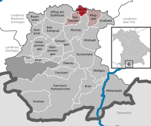
| Location of the community Spatzenhausen in the district of Garmisch-Partenkirchen | ||
  |
||


Spatzenhausen is a municipality in the Upper Bavarian district of Garmisch-Partenkirchen and a member of the Seehausen am Staffelsee administrative community . The place is part of the tourist region Das Blaue Land .
geography
Spatzenhausen is located in the Oberland region between the Staffelsee and Riegsee .
There is only the district Spatzenhausen.
The municipality has three officially named municipal parts (the type of settlement is indicated in brackets ):
- Hofheim ( Kirchdorf )
- Spatzenhausen ( parish village )
- Waltersberg (Kirchdorf)
history
Until the church is planted
The place was first mentioned in a document in the 12th century. He belonged to the Rentamt München and to the District Court of Weilheim of the Electorate of Bavaria .
In the course of the administrative reforms in the Kingdom of Bavaria , the municipality edict of 1818 created today's municipality, which belonged to the Weilheim district court .
Administrative community
Since the municipal reform in 1978, the municipality has been a member of the Seehausen am Staffelsee administrative association.
Population development
Between 1988 and 2018, the municipality grew from 689 to 750 by 61 inhabitants or 8.9%.
- 1961: 491 inhabitants
- 1970: 487 inhabitants
- 1987: 670 inhabitants
- 1991: 766 inhabitants
- 1995: 748 inhabitants
- 2000: 790 inhabitants
- 2005: 788 inhabitants
- 2010: 765 inhabitants
- 2015: 725 inhabitants
politics
mayor
Mayor is Aloisia Gastl (Free Voting Association ).
Municipal council
The municipal council has eight members who all belong to the Free Voting Community.
tax income
The municipal tax revenue amounted to € 534 thousand in 2011, of which the trade tax income (net) amounted to € 174 thousand. The community has been debt free since 2010.
coat of arms
The description of the coat of arms reads: In blue over a golden three-mountain, a golden crown, which covers a slanted golden log from which golden flames beat.
Architectural monuments
Economy and Infrastructure
Economy including agriculture and forestry
In 2011 there were a total of 80 employees at the workplace. Of these, there were none in the field of agriculture and forestry, 18 in the manufacturing sector and 30 in the trade and transport sector at the place of work. There were a total of 277 employees at the place of residence subject to social security contributions. In 2010 there were 31 agricultural holdings with an agricultural area of 810 ha.
traffic
The federal highway 2 runs through the village from Munich to Mittenwald . North of the village, the federal road 472 branches off from this road in the direction of Bad Tölz . In addition, the place can be reached with the lines 9601 and 9620 of the regional traffic Upper Bavaria .
education
In 2012 the following institution existed:
- Kindergarten with 40 places
Web links
- Entry on the coat of arms of Spatzenhausen in the database of the House of Bavarian History
- Website of the administrative association Seehausen
- Spatzenhausen: Official statistics of the LfStat
Individual references, comments
- ↑ "Data 2" sheet, Statistical Report A1200C 202041 Population of the municipalities, districts and administrative districts 1st quarter 2020 (population based on the 2011 census) ( help ).
- ^ Community Spatzenhausen in the local database of the Bavarian State Library Online . Bayerische Staatsbibliothek, accessed on September 5, 2019.
- ↑ districts on the community website
- ↑ Information on local history on the community website
- ↑ a b c - Municipal statistics 2012: Spatzenhausen (PDF file; 1.7 MB)
- ↑ Regionalverkehr Oberbayern - Route network plan for the district of Garmisch-Partenkirchen ( Memento of the original from May 12, 2013 in the Internet Archive ) Info: The archive link has been inserted automatically and has not yet been checked. Please check the original and archive link according to the instructions and then remove this notice. (PDF file; 518 kB)

Bad Bayersoien | Bad Kohlgrub | Eschenlohe | Ettal | Farchant | Garmisch-Partenkirchen | Grainau | Großweil | Krün | Mittenwald | Murnau am Staffelsee | Oberammergau | Oberau | Ohlstadt | Riegsee | Saulgrub | Schwaigen | Seehausen am Staffelsee | Sparrow House | Uffing am Staffelsee | Unterammergau | Wallgau
Unregulated areas: Ettaler Forst