
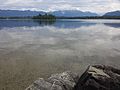
Staffelsee
| Staffelsee | ||
|---|---|---|

|
||
| Staffelsee from the east | ||
| Geographical location | Bavarian Alpine foothills , 60 km south of Munich | |
| Tributaries | Obernach , Röthenbach , Greinbach | |
| Drain | Oh → Ammer → Amper → Isar → Danube → Black Sea | |
| Islands | 7th | |
| Places on the shore | Seehausen , Uffing , Murnau | |
| Data | ||
| Coordinates | 47 ° 41 '27 " N , 11 ° 9' 39" E | |
|
||
| Altitude above sea level | 648.6 m above sea level NHN | |
| surface | 7.66 km² | |
| length | 4.6 km | |
| width | 3.75 km | |
| volume | 74,880,000 m³ | |
| scope | 19.31 km | |
| Maximum depth | 39.4 m | |
| Middle deep | 9.8 m | |
| PH value | 7.7 | |
| Catchment area | 80.66 km² | |
| Renewal time 1.28 years | ||

The Staffelsee is a 4.6 km long and 3.7 km wide lake in the Ammer-Loisach hill country in the southernmost district of Upper Bavaria , the district of Garmisch-Partenkirchen . It is almost eight square kilometers with a depth of up to almost 40 meters. Seven tree-lined islands make it the lake with the most islands in the foothills of the Alps.
Emergence
The kettle hole was created in the Wurm Age , whose basin was formed by the Loisach glacier. Because of its protected location between the molasse ribs of the Murnauer Mulde, the lake is only shallow. The base of the lake, the water level of which was about ten meters higher towards the end of the Würme Ice Age , has many conglomerate islands of the Upper Oligocene that were polished by the ice (so-called Wörth conglomerate).
Names
In the so-called Staffelsee inventory there is a report of a church property called “Staphinseie”. “Stafnensis” can be found as a Latinized form. It is not sufficiently clear whether these sites actually point to the Staffelsee.
But there is also a certain similarity to the Bavarian short forms Steffl or Stefferl for the first name Stefan or Stephan. The abbreviations Stoffl or Stofferl for Christoph can also be used. Other derivations bring the numerous shoals with the term “step” in the sense of stairs and the name in connection (easel / easel is a dialect expression in southern Germany with this meaning).
structure
The Staffelsee is divided into the three parts of the lake: Obersee, Untersee and Steg (see).
The Untersee is the northern part around the islands of Buchau, Gradeneiland and Mühlwörth, with the Uffinger Bay in the north. The Obersee is the south-western part around the islands of Große Birke and Kleine Birke. The Steg or Stegsee is the southeastern part with the islands of Wörth and Jakobsinsel. The latter was formerly called the Steginsel . The Burg peninsula protrudes into the Stegsee, separating the Seehauser Bay in the north from the Murnau Bay in the south. The Stegsee is also called Mittersee .
The border between Untersee in the north and Stegsee in the south runs in an east-west direction between the Kühle headlands ( 47 ° 41 ′ 23.7 ″ N , 011 ° 10 ′ 38.0 ″ E ) at Seehausen and Scharfes Eck ( 47 ° 41 ′ 25.9 ″ N , 011 ° 09 ′ 40.3 ″ E ) south of the Lindenbichl peninsula and touches the southern end of the Buchau. The border between the Obersee in the west and the Stegsee in the east runs in a north-south direction between the Scharfen Eck and the Geratsried on the south bank of the lake, with the island of Wörth being counted entirely as part of the Stegsee.
Islands
The lake has seven islands. In 1853 it was said to have an area of more than 2000 days, a depth of 5–24 fathoms and 7 islands named Oberpirka, Unterpirka, Wörth, S. Jakob or Steginsel, Bucha, Gradeneila and Milliwörtl. The islands are upscale molasse fragments detached from their context . The storage of the lake basin is severely disturbed molasses.


The following table provides an overview of the islands (from southwest via southeast to north) with area information:
![]() Map with all coordinates: OSM | WikiMap
Map with all coordinates: OSM | WikiMap
|

The islands are of very different sizes. Wörth is the largest and the only one that is permanently inhabited. The boat connection from Seehausen to the island of Wörth leads south past the Jakobsinsel.
- The Big Birch , the third largest island, offers a small campsite, which is operated by the Bavarian Canoe Association and is only open to members of the German Canoe Association . The island is not approached by the Staffelseeschiffahrt and can therefore only be reached with your own boats.
- The Jakobsinsel (St. Jakob) , the smallest island: the boardwalk used to lead across the island from the mainland (Burg peninsula) to the island of Wörth. This was probably built for the first time in the 11th century when the former monastery church became a parish church, so that the latter was more easily accessible for the parishioners on the Staffelseeufer. A picture from 1770 shows the footbridge, the posts of which are still visible under water and where freshwater sponges have settled. The sponges of the genus Spongilla lacustris , which are rarely found in Europe, were only discovered in 2003. In specialist books, they are never listed larger than 30 cm, but in Staffelsee they are more than the size of a man. According to a booklet from 1853, the footbridge still existed at that time.
Shallows
On the Staffelsee map from 1890 a total of 19 mostly named shoals are recorded, two of them in the Obersee, five in the Stegsee and twelve in the Untersee (including one unnamed). 17 of the shallows are named, two of them ( Grad Eiland and St. Jakob ) are named after the islands near them. Only two of these historically marked points are actually elevations on the lake bed that reach close to the surface, as can be determined using a modern contour map:
The stone , located 260 meters north-northwest of the island of Buchau in the Untersee at 47 ° 41 ′ 51 ″ N , 11 ° 10 ′ 26.9 ″ E, is the most famous shoal in the Staffelsee. It has a shallowest water depth of only around 60 centimeters. The deepest part of the Staffelsee at 39.4 meters is only 400 meters northwest of this point. At the grove is another shoal, only about 60 centimeters deep, located in the Obersee at 47 ° 41 ′ 10.9 ″ N , 11 ° 9 ′ 18.2 ″ E , 250 meters west of the northwest tip of the island of Wörth.
Peninsulas
.jpg)
- The peninsula Linde Bichl is located on the western shore 300 meters west of north of the island in the sea portion Buchau submarine ( 47 ° 41 '34 " N , 11 ° 9' 55.9" O ). It is 2.6 hectares in size and 230 meters long and, like the rest of the western and northern shores of the lake, belongs to the municipality of Uffing . It used to be an island and is now only connected to the mainland by a strip of moorland that is less than 50 meters wide . It can only be reached by boat and is not accessible from the mainland, as the moor is the only connection to the mainland and is designated as a nature reserve and therefore cannot be entered. There used to be a jetty on the east bank that no longer exists. The peninsula is leased by the Protestant youth in Weilheim , who have organized a children's tent camp here every summer since 1953 , which is very popular. The peninsula can be reached via a small motorboat called the Titanic and is supplied with it. The groups come to the peninsula with the MS Seehausen and a ferry, the Blende. 500 meters further north, across the peninsula on the north west bank, is the large campground at Am Aichale or Aichalehof .
- The Burg peninsula connects to the west of the Seehausen district of the Seehausen community on the southern eastern shore in Stegsee, at 47 ° 41 ′ 5.1 ″ N , 11 ° 10 ′ 38.5 ″ E , and also belongs to the Seehausen community. It is 1.7 hectares and has a campsite . The eastern end of the island of Wörth is 260 meters to the west. Halfway there is the small Jakobsinsel, over which the wooden walkway used to lead from the mainland to the island of Wörth. The Burg peninsula separates the Murnau Bay in the south from the Seehaus Bay in the north.
- Officially, the Staffelsee only has the two aforementioned peninsulas. However, the Achmündung in the southwest (upper lake), with country firmly gewordenem island hill, also a peninsula (or the hill a former island), which extends almost 400 meters into the lake, with a width of 50 to 100 meters and an area of approximately 3 hectares, at 47 ° 41 '1 " N , 11 ° 8' 31" O .
administration
Almost the entire area of the lake belongs to the municipality of Seehausen. In the north and west, the municipality of Uffing also has a share of the lakeshore, in the extreme southeast the Murnau market has 210 meters of lakefront between the Murnau lido and the ship landing stage. The actual lake without the bank areas is the property of the Free State of Bavaria, for whose administration the Bavarian Administration of State Palaces, Gardens and Lakes is responsible.
tourism
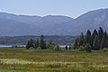
The lake is a popular bathing lake with mild, moor-containing water that is quickly warmed up by the lake's depression. The surroundings can be explored on a circular hiking trail with a length of 22 km. Rowing boats and pedal boats can be rented during the summer months and fishing is possible from mid-May to mid-October. In winter, ice skaters, ice hockey players and curlers find a wide field of activity on the extensive ice surface. The MS Seehausen passenger ship operates between the neighboring communities of Murnau , Seehausen a.Staffelsee and Uffing .
Ecosystem
The Staffelsee is a eutrophic waters and has, thanks to a ring drains very clean water in drinking quality. Therefore, it is a very popular fishing ground with anglers. Pike lurk for whitefish and tench near the extensive bank areas . There are also eels , carp , pikeperch and many white fish .
The high level of use as a local recreation area in Munich ensures that the lake only plays a minor role as a resting place for water birds until late summer. Between December and March, the lake is completely or partially frozen for one to three months about every third year. The largest resting populations are therefore reached in autumn, i.e. at the time of the hunt. The hunting routes are available from 10 years (1985/86 and 1988/89 to 1995/96). Were reported mallards , coots , tufted ducks , mute swans , Canada geese and black-headed gulls . To protect the species, motorboats are not allowed on the Staffelsee.
History and culture
Since 1476, the lake was completely owned by the Ettal monastery court . The individual fishing rights fell to the monastery court partly from the Lords of Seefeld (1341), partly from the Lords of Preysing (1471) and the Höhenkirchen zu Uffing (1475 and 1476).
Since 1935 there has been a sea procession or ship procession every year on Corpus Christi . From the village church, the train pulls through the streets of Seehausen to the lake, from there on by boat to the Simpert Chapel (St. Bonifatius) on the island of Wörth. The Staffelsee Monastery was located here for a short time. One source describes it as “Ecclesia Stafnensis” and was probably destroyed by the Hungarians in the 10th century. Simpert , the last Neuburg bishop, was called “Bishop of Neuburg im Staffelsee” (Simpert Episcopus Stafnensis ecclesiae) around the year 800. The monastery can therefore possibly be seen as the second seat of the Neuburg diocese . However, even after excavations on the island of Wörth, none of the relevant information can be classified as certain.
Quote
Ödön von Horváth described the Staffelsee as " ... the most beautiful place on the northern edge of the Bavarian Alps ... "

At the Murnau lido

With MS Seehausen

Western bank in the Tannenbach-Filz

View from 1900

Mühlwörth island from the north
Staffelsee with the island of Mühlwörth
western Staffelsee with moss landscape
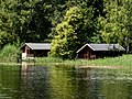
Boathouses on the Staffelsee


See also
literature
- Peter Blath: The Staffelsee and its neighboring communities. Sutton Verlag, Erfurt 2006, ISBN 978-3-86680-039-7 .
- Rolf KF Meyer, Hermann Schmidt-Kaler: On the trail of the Ice Age south of Munich -Eastern part- (= walks in the history of the earth ; 8). Friedrich Pfeil, Munich 2002, ISBN 3-931516-09-1 .
- Johann Baptist Prechtl : The Staffelsee . Munich 1853 ( digitized version ).
Web links
- Bavarian Administration of State Palaces, Gardens and Lakes : Staffelsee
- Geological history of the Habach area
Individual evidence
- ↑ a b c d e Documentation of the condition and development of the most important lakes in Germany: Part 11 Bavaria (PDF; 1.7 MB)
- ↑ Longest point: 4.60 km: distance between the most easterly 47 ° 40 ′ 50.9 ″ N , 11 ° 11 ′ 14.9 ″ E and the most westerly point 47 ° 41 ′ 20.9 ″ N , 11 ° 7 ′ 54.7 " O .
- ↑ Widest point: 3.75 km: distance between the southernmost point 47 ° 40 ′ 40.7 ″ N , 11 ° 9 ′ 42.6 ″ E and the northernmost point 47 ° 42 ′ 39 ″ N , 11 ° 10 ′ 6, 6 " O .
- ↑ Information sheet from the Weilheim Water Management Office (PDF; 82 kB)
- ^ A b c E. Bezzel and I. Geiersberger, Water Bird Hunting on the Staffelsee
- ↑ schloesser.bayern.de
- ^ Theodor von der Goltz, History of German Agriculture
- ↑ Apartment at the Staffelsee
- ↑ a b J. B. Prechtl: The Staffelsee. Munich 1853, p. 3
- ↑ Hansjakob Gebhart: Staffelsee Chronicle. Murnau 1931, p. 79
- ↑ a b c Bürgerblatt für Uffing and Scheffau, 34/2014, Part 1 , pp. 20–21: Historical Staffelseekarte
- ↑ Alois Geistbeck: The South Bavarian and North Tyrolean lakes. In: Journal of the German and Austrian Alpine Association, year 1885, Volume XVI, pp. 334–354, here p. 346.
- ↑ Portrait: Local rarities. Original, soft and tough. ( Memento of March 11, 2012 in the Internet Archive ) BUND magazine 1/2003, page 40 (PDF; 1.2 MB)
- ^ Bavarian State Ministry for Environment and Health: Environmental object catalog: Spongilla lacustris - Staffelsee
- ↑ Staffelseeschifffahrt: freshwater sponge
- ^ Johann Baptist Prechtl: Der Staffelsee, Munich 1853 , p. 4: miserable footbridge
- ^ Staffelsee on the Bay's website. Lock management
- ↑ The Staffelsee on angeln.de
- ↑ Dieter Albrecht: The monastery courts Benediktbeuern and Ettal . In: Historical Atlas of Bavaria . Altbayern series I issue 6.Munich 1953, p. 31 ( online ).
- ↑ Historical Lexicon of Bavaria
- ↑ Simbert of Augsburg
- ^ Excavations on the island of Wörth

Altenauer Moor | Ammer Mountains | Ammerschlucht at the Echelsbacher Bridge | Ammer Gorge in the Scheibum area | Arnspitze | Humpback meadows on the goat skull | Humpback meadows on the Plattele | Ettaler Weidmoos | Froschhauser See | Karwendel and Karwendel foothills | Kochelfilz near Unterammergau | Murnauer Moos | Powder moss | Riedboden | Schachen and Reintal | Western Staffelsee with adjacent moors