Mühlwörth
| Mühlwörth ( Raven Island ) |
||
|---|---|---|
| Mühlwörth island from the north | ||
| Waters | Staffelsee | |
| Geographical location | 47 ° 42 '15.1 " N , 11 ° 9' 53.3" E | |
|
|
||
| length | 135 m | |
| width | 95 m | |
| surface | 0.756 ha | |
| Residents | uninhabited | |
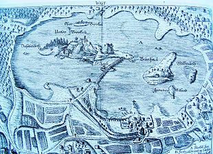
| Map of the Staffelsee, with Mühlwörth in the north | ||
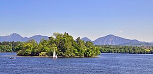
Mühlwörth , popularly also Rabeninsel by a previously nächtigenden there Rabenschwarm , is the northernmost island in the Staffelsee in Bavaria and is located in the submarine before Uffinger Bay . An older variant of the name is Milliwörtl .
The island is around 320 meters from the north-western shore. Like the other islands in the Staffelsee and like the Staffelsee itself, it belongs to the municipality and district of Seehausen am Staffelsee in the Garmisch-Partenkirchen district .
With a size of 7560 m², the island is the fourth largest of the seven islands in the Staffelsee. The island is privately owned and not open to the public. There is only a weekend house , a boat hut and a bathing hut on it. It has a dense tree population and is located in a protected landscape area .
supporting documents
- ^ JB Prechtl: The Staffelsee. Munich 1853, p. 3.
- ^ Manfred Schmidt: Stream and inland lake islands in Germany. Grin Verlag, Munich 2008, ISBN 978-3-638-95278-1 .


