
Ettal
| coat of arms | Germany map | |
|---|---|---|

|
Coordinates: 47 ° 34 ' N , 11 ° 6' E |
|
| Basic data | ||
| State : | Bavaria | |
| Administrative region : | Upper Bavaria | |
| County : | Garmisch-Partenkirchen | |
| Management Community : | Unterammergau | |
| Height : | 877 m above sea level NHN | |
| Area : | 14.75 km 2 | |
| Residents: | 758 (Dec. 31, 2019) | |
| Population density : | 51 inhabitants per km 2 | |
| Postal code : | 82488 | |
| Area code : | 08822 | |
| License plate : | Cap | |
| Community key : | 09 1 80 115 | |
| LOCODE : | DE ETY | |
| Community structure: | 5 parts of the community | |
| Address of the municipal administration: |
Ammergauer Str. 8 82488 Ettal |
|
| Website : | ||
| Mayor : | Vanessa Voit ( FWG ) | |
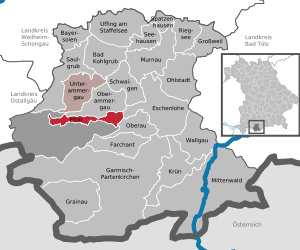
| Location of the community Ettal in the district of Garmisch-Partenkirchen | ||
  |
||

Ettal is a small community in the Upper Bavarian district of Garmisch-Partenkirchen . The main attractions are Ettal Abbey and Linderhof Palace .
geography
location
The community is located around ten kilometers north of Garmisch-Partenkirchen in the Oberland region on the Ettaler Sattel , between Oberammergau in the Ammertal valley, five kilometers north-west, and Oberau , which lies around five kilometers south-east in the Loisach valley . The federal highway 23 connects the mentioned places. It borders on the Ammer Mountains . Ettal is located in the Ammergau Alps Nature Park . The municipality extends in a west-east direction from Linderhof over the Graswang valley to Ettaler Weidmoos .
Parish parts
The municipality has five officially named municipal parts (the type of settlement is given in brackets ):
- Dickelschwaig ( wasteland )
- Ettal ( parish village )
- Graswang ( Kirchdorf )
- Linderhof ( village )
- Cream (wasteland)
climate

The annual precipitation is 1565 mm and is therefore in the top thirtieth of the values recorded by the measuring points of the German Weather Service . The driest month is October; it rains most in July. In the wettest month there is about 2.4 times more rain than in the driest month. This means that Ettal is in the top hundredth of all measuring stations for seasonal fluctuations in precipitation.
history
Until the church is planted
Ettal Abbey was founded by Emperor Ludwig the Bavarian in the Graswang Valley on April 28, 1330 as part of a pledge. Before 1803, the place Ettal was the seat of an upper and lower court of the private (formerly imperial direct ) monastery court Ettal. Ettal Abbey was secularized in 1803 and its possessions went to the state. The former monastery buildings were auctioned off by the state and new families settled there.
The political municipality of Ettal came into being with the municipal edict of 1818 and consisted of the farmers from Graswang and Linderhof and the families in Ettal. The community was subordinate to the regional court of Schongau .
19th to 21st century
Parish and school were housed in the former monastery to the right of the church. In a modest community, a band with singers developed, the volunteer fire brigades in Ettal and Graswang, the veterans' association after the war in 1870/71 and the folk costume association in 1899. On the grounds of the Linderhof, which was owned by the Wittelsbach family , King Ludwig II had Linderhof Palace built with large parks from 1869 .
After several changes of ownership, Scheyern Monastery acquired the former monastery buildings in 1900 and initially founded a priory , which was elevated to an abbey again in 1907 . Today the monastery next to the abbey also house a boy internat with day care center and a school , the Benedictine Ettal school .
Thermal power plant
In 1878 Sigmund Schuckert built the world's first thermal power station in Linderhof . It consisted of 24 generators driven by a steam engine and was used to operate permanent electrical lighting in Linderhof Palace.
Population development
Between 1988 and 2018 the population decreased from 955 to 775 by 180 inhabitants or 18.9%.
| year | 1910 | 1970 | 1987 | 1991 | 1995 | 2000 | 2005 | 2010 | 2015 |
|---|---|---|---|---|---|---|---|---|---|
| Residents | 741 | 1022 | 911 | 981 | 964 | 860 | 813 | 784 | 789 |
politics
The community is a member of the Unterammergau administrative community
mayor
Mayor has been Vanessa Voit (Free Voting Association Ettal) since May 1, 2020.
Municipal council
The municipal council consists of eight members, all of whom belong to the Ettal Free Voting Association.
coat of arms
|
|
Blazon : “Divided by gold and blue; above a growing, red armored black two-headed eagle, below the word "etal" in Gothic lowercase letters. " |
Meaning: The double-headed eagle goes back to the founder Emperor Ludwig the Bavarian, whose heraldic animal was this eagle. "Etal" is the original name of Ettal and means valley of marriage (vow, promise). Emperor Ludwig the Bavarian made the promise to found a monastery at this point.
Buildings
Above all are world famous
- the Ettal Monastery with its Baroque style domed church of the Assumption
- the Linderhof Castle , which King Ludwig II. was built in the 19th century
See also: List of architectural monuments in Ettal and List of ground monuments in Ettal
Economy and Infrastructure
Economy including agriculture and forestry
The Ettal Monastery and its businesses are of particular economic importance. The monastery includes farms, several inns and a high school with an attached boarding school and an art publisher.
education
The following facilities exist:
- a kindergarten
- the Benedictine high school in Ettal with an attached boarding school and day care center with around 450 students
tourism
The community belongs to the Ammergau Alps tourist region. The region is represented in terms of tourism by the Ammergauer Alpen GmbH. In addition to Ettal, the Ammergau Alps nature park region includes the towns of Oberammergau , Unterammergau , Bad Bayersoien , Bad Kohlgrub and Saulgrub / Altenau / Wurmansau.
In 2018, over 113,000 overnight stays and around 61,000 arrivals were generated in the municipality.
Personalities
- Franz Ludwig Herrmann (1723–1791), baroque painter
- Egid Verhelst the Younger (1733–1804), well-known copperplate engraver, academy professor in Mannheim
- Sergei Sergejewitsch Prokofjew (1891–1953), composer, lived in Ettal from 1922 to 1923
- Mirl Buchner (1924–2014), ski racer, medalist at the 1952 Winter Olympics in Oslo

Ettal around 1900

Ettal from the Ochsensitz

Ettal monastery church

Linderhof Palace

Maria-Schutz-Kirche


Web links
- Ettal municipality
- Ettal in Panoport travel guide ammergau.de
- Ettal (Ammergau Alps tourism portal)
- Ettal: Official statistics of the LfStat
Individual evidence
- ↑ "Data 2" sheet, Statistical Report A1200C 202041 Population of the municipalities, districts and administrative districts 1st quarter 2020 (population based on the 2011 census) ( help ).
- ↑ Municipal Council. Ettal municipality, accessed on June 27, 2020 .
- ^ Municipality of Ettal in the local database of the Bavarian State Library Online . Bayerische Staatsbibliothek, accessed on September 6, 2019.
- ↑ Over 97 percent of all measuring points show lower values.
- ^ David Gugerli: Streams of Speech. For the electrification of Switzerland. 1880-1914 . Chronos, Zurich 1996, ISBN 3-905311-91-7 (also: Zurich, university, habilitation thesis, 1994/1995)
- ^ Entry on the Ettal coat of arms in the database of the House of Bavarian History
Ettal | Dickelschwaig | Graswang | Linderhof | cream

Bad Bayersoien | Bad Kohlgrub | Eschenlohe | Ettal | Farchant | Garmisch-Partenkirchen | Grainau | Großweil | Krün | Mittenwald | Murnau am Staffelsee | Oberammergau | Oberau | Ohlstadt | Riegsee | Saulgrub | Schwaigen | Seehausen am Staffelsee | Sparrow House | Uffing am Staffelsee | Unterammergau | Wallgau
Unregulated areas: Ettaler Forst