Ammergau Alps
| Ammergau Alps | |
|---|---|
|
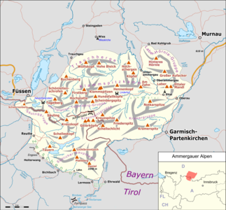
Location of the Ammergau Alps within the Eastern Alps |
|
|
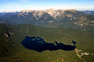
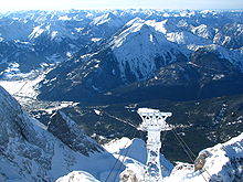
View from the Zugspitze to the Ammer Mountains with the Eibsee in the foreground |
|
| Highest peak | Daniel ( 2340 m above sea level ) |
| location | Bavaria / Tyrol border |
| part of |
Bavarian Alps in the Northern Eastern Alps |
| Classification according to |
AVE : 7a SOIUSA : 22.III |
| Coordinates | 47 ° 26 ' N , 10 ° 53' E |
| surface | 637.0 km²
|
The Ammergau Alps , also known as the Ammer Mountains , are a mountain group of the Northern Limestone Alps in the Bavarian administrative districts of Upper Bavaria and Swabia and in the Tyrolean district of Reutte (Ausserfern) . They cover an area of about 30 x 30 kilometers. The eponymous river Ammer rises in the middle . The highest peak is the Daniel at 2340 meters . The landscape is extremely sparsely populated, but includes some well-known sights: the royal castles of Neuschwanstein and Linderhof , the Ettal monastery and the Wieskirche . In Germany partial regions of natural areas Ammer Mountains, Ammer-Loisach-Hügelland and Lech Foothills with an area of approximately 227.38 square kilometers to have been in August 2017 Ammergau Alps Nature Park explained.
Geography and tourist infrastructure
The states of Germany (about ¾ of the area) with the Free State of Bavaria and Austria with the state of Tyrol have a share in the Ammergau Alps . The villages of Schwangau , Oberammergau , Garmisch-Partenkirchen , Ehrwald and Reutte frame the mountains. Because of the comparatively low height of their peaks and their location on the northern edge of the Alps, the Ammergau Alps with their proximity to the metropolitan areas of southern Germany are an ideal area for average mountain hikers. Most of the peaks can be reached as day tours from the valley locations. This results in only a small number of Alpine Club huts . The development with mountain railways is also low. Only in the northern peripheral areas are there two cable cars ( Tegelberg , Laber Bergbahn ) and three chair lifts ( Buchenberg , Vorderes Hörnle , Kolbensattel ). In the central and southern areas there are no mountain railways or accommodation huts. Only one bus connection takes hikers to the privately run Kenzenhütte . The border between the Bavarian administrative districts of Upper Bavaria and Swabia , which is also the district border between Garmisch-Partenkirchen and Ostallgäu , runs from south to north through the Ammergau Alps.
geology
Geologically, the Ammergau Alps are largely made up of main dolomite , which forms prominent peaks such as the Kreuzspitze . In general, the entire southern section of the mountain range consists of dolomite with small amounts of limestone , which is why it shows relatively monotonous shapes. The northern part is more varied with a complicated change in the sequence of layers of the rocks. In addition to the dolomite, there are smaller areas in which the Wetterstein limestone dominates. The Hochplatte and the Säuling are the most impressive mountains made from this rock. In addition, small areas of clay stones, marl , sandstones , radiolarites , conglomerates and silica limestone enrich the landscape. Close to the edge of the Alps, however, the flysch appears across the board ( Hohe Bleick , Hörnle ). Because of its susceptibility to erosion, the flysch forms round mountains, often wooded to the top, with a low mountain range character.
The widespread use of dolomite causes a typical phenomenon in the Ammergau Alps: huge streams of dolomite rubble, the so-called Gries , which spill entire valleys ( Graswangtal ). The most intensive accumulation of debris can be found in the area of the Kreuzspitze and in the northern flanks of the southern main ridge. The Friedergries and the Lindergries are remarkable debris areas in the valley area. A special feature is the boiler , a large sinkhole funnel in the area of the Hasental head , which was deepened by rock solution .
natural reserve
The Ammergebirge has remained a relatively natural, little developed mountain range with a very low population density . A large part of the mountain range forms the 288 km² large nature reserve Ammergebirge , the largest nature reserve in Bavaria.
With effect from August 1, 2017, an area of around 227.38 km² was declared the Ammergau Alps Nature Park . It includes the six municipalities of Ettal, Oberammergau, Unterammergau, Saulgrub-Altenau, Bad Kohlgrub and Bad Bayersoien. The designation of a national park in the Ammer Mountains has been discussed since 2005.
Flora
Due to the constant movement of the semolina, they are also of great ecological value, because this dynamic enables the existence of rare plants. In Friedergries z. B. the rare tree species Spirke , which is only competitive with frequent rubble movement. There are also numerous other rare plants. The mainly southern alpine plant species Soldanella minima ssp. minima (ice bells) and the Monte Baldo sedge have their only occurrence in the Ammergau mountains in the northern Alps. The diverse high and low moors are of international importance . Certain forest communities are also very valuable, such as unique block and ravine forests or variegated saddleback pine forests . Extensive meadow uses such as poor grassland , wet grassland and nebulas enrich the flora.
Lakes
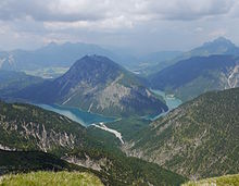
With the Plansee and the Heiterwanger See , the Ammergau Alps have two of the most beautiful lakes in Tyrol. The lakes are located in a valley (a rarity in the Northern Limestone Alps) and cut into the wooded mountain slopes like a fjord . Their banks are almost undeveloped. There are other lakes on the north-western edge of the mountains, the Alpsee , Schwansee and Bannwaldsee as well as the Soier See in Bad Bayersoien .
Moors
In the Ammergau Alps, alpine mountain pine raised bogs are extracted from around two dozen bog holes in Bad Kohlgrub and Bad Bayersoien and delivered to health establishments, health establishments and hotels in both places. The mosses and felts in the Ammertal and its neighborhood are due to the last ice age , which ended around 10,000 years ago.
Economy and culture
The human use that shapes the landscape most of all is forestry , which has changed the natural composition of the forests in some cases significantly and has built up a relatively dense network of forest roads. In some areas (e.g. at Friederspitz ), too intensive sheep grazing causes problems due to the destruction by erosion of alpine grass slopes. In contrast to the neighboring mountain groups in the west and south-west, the Ammergau Alps have only a few meadows and alpine pastures. Most of the mountain is covered with forest. This is due the fact that large parts of the Ammergau Alps were a royal hunting ground and that dolomite - and Flyschböden for pasture and grassland farming unfavorable conditions create (dry, poor soils in dolomite or to rutschungsanfällig the flysch).
The most important industry in the region is tourism .
In the Ammergau Alps there are architectural works of art of international standing. These include the castles Linderhof and Neuschwanstein as well as the Ettal monastery .
Oberammergau is known for its wood carvers and Lüftlmalerei , as well as for the Oberammergau Passion Play that takes place every ten years . Numerous cultural events take place every year in the Passion Play Theater in Oberammergau, which was built especially for this purpose.
structure
Boundary
In the north, the Alpine foothills form the border from the Lech to the Loisach . The Lech forms the border in the west from its exit into the Alpine foothills upstream to Reutte . The Loisach delimits the Ammergau Alps in the east, south-east and south from its exit into the Alpine foothills upstream to the Ehrwald Basin . In the southwest, the valley called Zwischenentoren connects the Ehrwald basin and the Reutten valley basin.
The intermediate gate also forms a barely pronounced valley pass that connects the Ammergau Alps with the Lechtal Alps.
Subgroups
The Alpine Club Guide Allgäu Alps and Ammergau Alps divides the Ammergau Alps into the following sub-groups (each with the highest peak):
|
|
The Kreuzspitz group with the Kreuzspitze and the Geierköpf represent the most alpine part of the Ammergau Alps. The highest peaks are in the southern main ridge (Danielkamm). The most diverse and touristically interesting part of the mountains is in the Hochplatten-Tegelberg group.
summit
The ten highest peaks in the Ammergau Alps:
| 1. | Daniel | 2340 m | 6th | Big Pfuitjöchle | 2197 m | |
| 2. | Up tip | 2332 m | 7th | Cross point | 2185 m | |
| 3. | Plattberg (Hochschrutte) | 2247 m | 8th. | Pitzenegg | 2179 m | |
| 4th | Büchsentaljoch | 2244 m | 9. | Vulture heads | 2164 m | |
| 5. | Kohlbergspitze | 2202 m | 10. | Little Pfuitjöchle | 2145 m |
Other summit:
In the Ammergau Alps there are about 200 named and with spot elevation provided Summit. The better known include (in order of height):
|
|
Neighboring mountain groups
The Ammergau Alps border the following other mountain groups in the Alps:
- Allgäu Alps (in the west)
- Lechtal Alps (in the southwest)
- Wetterstein Mountains and Mieming Range (in the south)
- Ester Mountains and Bavarian Prealps (in the east)
In the north, the Ammergau Alps border the Alpine foothills .
Localities
- Oberammergau
- Ettal / Graswang / Linderhof
- Unterammergau
- Saulgrub / Altenau / Wurmansau
- Bad Kohlgrub
- Bad Bayersoien
- Halbch
- Schwangau
tourism
Ammergau Alps tourist region
The following places have come together to form the Ammergau Alps tourism region:
- Oberammergau
- Ettal / Graswang / Linderhof
- Unterammergau
- Saulgrub / Altenau / Wurmansau
- Bad Kohlgrub
- Bad Bayersoien
In 2018, the region recorded more than 806,000 overnight stays and over 238,000 arrivals.
Long-distance and long-distance hiking trails
The Via Alpina , a cross-border long-distance hiking trail with five partial trails through the entire Alps, also runs through the Ammergau Alps. The purple path of Via Alpina leads through the Ammergau Alps in three stages as follows:
- Stage A60 from Garmisch-Partenkirchen to Linderhof
- Stage A61 from Linderhof to Kenzenhütte
- Stage A62 from the Kenzenhütte to Füssen
Another long-distance hiking trail in the Ammergau Alps is the meditation trail. It leads from the Wieskirche in Steingaden through the Ammer Valley to Linderhof Palace in the Graswang Valley . The path is 87 kilometers long and can be climbed in several daily stages. There are 15 stations on the way to meditate and gain strength.
In the valleys of the Ammergau Alps between Bad Bayersoien, Bad Kohlgrub, Saulgrub / Altenau, Unterammergau, Oberammergau, Ettal, and Linderhof Castle, there are widely branched and mostly very snow- reliable cross-country trails in winter . Every year on the first weekend in February, the famous König-Ludwig-Lauf takes place here between Ettal, Linderhof Castle and Oberammergau.
There is also a large network of hiking and biking trails available. B .:
- Oberammergau - Unterammergau (Altherrenweg)
- Oberammergau - Ettal (Vogelherdweg)
- Oberammergau - Linderhof (Sonnenweg)
Mountain railways
- Tegelbergbahn Schwangau
- Laber mountain railway in Oberammergau
- Kolbensesselbahn in Oberammergau: at the mountain station there is a climbing forest and an Alpine Coaster (2.6 km long route into the valley)
- Hörnle-Bahn in Bad Kohlgrub: In winter there is a 4.5 km long toboggan run .
Alpine skiing opportunities exist in Oberammergau, Bad Kohlgrub and Unterammergau (Steckenberg lifts)
Mountain huts
In the Bavarian part of the Ammergau Alps there are three Alpine Club huts and some privately operated huts. There are no Alpine Club huts in the Tyrolean part of the mountains.
- August-Schuster-Haus on the Pürschling: 1564 m , open all year round, closed in November, 54 beds, 12 mattresses. Valley location: Unterammergau, walking time from Unterammergau 2 hours
- Brunnenkopfhäuser : 1602 m , managed from Whitsuntide to October, 35 mattress dormitories. Valley location: Oberammergau, walking time from Linderhof Palace 1.75 hours
- Hörndlhütte : 1390 m , open in summer from the beginning of May to the end of October, in winter from the beginning of December to the end of March, closed in April and November, 23 mattress dormitories. Valley location: Bad Kohlgrub, walking time from Bad Kohlgrub 1.25 hours
- Kenzenhütte : 1294 m . Valley location: Halch, accessible from there with the "Kenzenbus"
- Säulinghaus : 1693 m , Naturfreundehütte below the Säuling summit, managed in summer, 48 beds and storage, walking time from Pflach 2 hours
- Kolbensattelhütte
- Soila Alm
- Hörnle Alm
- Laber mountain inn
- Mountain restaurant Romanshöhe ( Aufacker )
- Berggasthof Kolbenalm
Sights in the tourist region
- Neuschwanstein Castle
- Castle Hohenschwangau
- Linderhof Palace
- Ettal Abbey
- Lüftlmalerei on the house facades
- Bayersoiener See
- Passion Play Theater Oberammergau
- Oberammergau Museum
- Schleifmühlklamm Unterammergau
- Bunting breakthrough Scheibum
- Hörnle
- Laber mountain railway
- Church of Saints Peter and Paul
- Wood carving
- Crucifixion group
- Pilate House
literature
- Dieter Seibert: AVF Allgäuer Alpen and Ammergauer Alpen , Rother Verlag Munich 2004, ISBN 3-7633-1126-2
Web links
- Tours and peaks of the Ammergau Alps , on steinmandl.de
- List of mountain tours in the Ammergau Alps , route descriptions & area information
- Area and boundary of the Ammergau Alps , on GeoFinder.ch
- Ammergauer-Alpen tourist region , at ammergauer-alpen.de
Individual evidence
- ↑ a b Declaration on the "Ammergau Alps Nature Park" , announced on July 27, 2017, in the General Ministerialblatt (AllMBl) of the Bavarian State Ministry of the Interior, for Building and Transport , p. 338 (PDF; 1.96 MB)
- ↑ Ammergau Alps Nature Park. Retrieved November 11, 2016 .
- ↑ Ammergau Alps Nature Park . In: Bayerische Staatszeitung, September 5, 2014, p. 7, accessed on December 9, 2016
- ↑ Shortly before the goal. In: Bayerische Staatszeitung, March 18, 2016, p. 13, accessed December 9, 2016
- ↑ Christian Sebald: Opinions are divided on the Ammer Mountains , in: 'Süddeutsche Zeitung' from 24./25. September 2011, p. 50
- ↑ Ralf Müller: Greens are pushing for the Ammer Mountains National Park . In: merkur-online.de , September 12, 2011. Retrieved September 26, 2011
- ^ Moore , in Ammergauer Alpen , on ammergauer-alpen.de
- ↑ Carving and craftsmanship. Retrieved November 11, 2016 . , on ammergauer-alpen.de
- ↑ Ammergau Alps tourism region. Retrieved November 11, 2016 . , on ammergauer-alpen.de
