Hochplatte (Ammergau Alps)
| High plate | ||
|---|---|---|
|
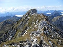
East view of the Ammergau plateau |
||
| height | 2082 m above sea level NN | |
| location | Bavaria , Germany | |
| Mountains | Ammergau Alps | |
| Dominance | 4.3 km → Vulture heads | |
| Notch height | 964 m ↓ Ammersattel | |
| Coordinates | 47 ° 33 '11 " N , 10 ° 50' 36" E | |
|
|
||
| rock | Wetterstein lime | |
| Age of the rock | Triad | |
| Normal way | Kenzenhütte - Scheinbergalpe - east side - Hochplatte (east rise) | |
The high plateau is a 2082 m above sea level. NHN high mountain in the Ammergau Alps and the highest point in the Ostallgäu district . To better distinguish it from other mountains with this name in the Northern Limestone Alps , it is also referred to as the Ammergauer Hochplatte . It is a striking rock slab made of Wetterstein limestone, clearly towering over the area, with an east and the main summit. Due to its exposed location as a panoramic mountain , the Hochplatte is a popular destination for hikes and ski tours .
location
The summit is about seven kilometers east of Füssen in the German state of Bavaria . Neighboring mountains are in the west (towards Füssen) and northwest Krähe , Gabelschrofen , Gumpenkarspitze and Geiselstein 1884 m above sea level. NHN and north of the Firstberg 1783 m above sea level. NHN . To the east, the Scheinbergspitze is 1929 m above sea level. NHN . To the south, the karst terrain slopes down to the Ammersattel . The high plateau is located in the Ammergebirge nature reserve (NSG-00274.01).
Base and tours
- The easiest way to the high plateau leads from the Kenzenhütte 1294 m above sea level. NHN over the Scheinbergalpe and then through karst terrain over the east side to the summit. According to literature, the ascent takes about two and a half hours. In fact, at least 3 hours should be expected.
- A more demanding tour (according to the literature, UIAA I level of difficulty ) leads from the Kenzenhütte in a good three hours over the Gumpenkar from the west to the summit. Wire rope insurances are available in difficult places.
gallery
Literature and map
- Dieter Seibert: Alpine Club Guide Allgäu and Ammergau Alps . Bergverlag Rother , Munich 2004, ISBN 3-7633-1126-2
- Freytag & Berndt , hiking map 1: 50,000, sheet WK 352
Web links
- Route description in the hiking guide, view in Google Books
- Ammergauer Hochplatte ski tour - route description
Individual evidence
- ↑ Geological map of Bavaria with explanations (1: 500,000). Bavarian Geological State Office, 1998.
- ↑ Federal Agency for Cartography and Geodesy , State Office for Surveying and Geoinformation Bavaria : Digital Topographic Map 1:25 000, BayernAtlas , accessed on January 9, 2016
- ↑ protectedplanet.net


