
Vulture heads
| Vulture heads | ||
|---|---|---|
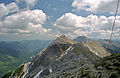
 South side of the vulture heads from the east (from the left west, main and east peaks) |
||
| height | 2161 m above sea level A. | |
| location |
|
|
| Mountains | Ammergau Alps | |
| Dominance | 3.3 km → Kreuzspitze | |
| Notch height | 495 m ↓ Neualmsattel | |
| Coordinates | 47 ° 31 '11 " N , 10 ° 52' 30" E | |
|
||
| rock | Main dolomite | |
| Age of the rock | Upper Carnium - Norium | |
| First ascent | touristic by Zeno Diemer with his wife and Andreas Lang on September 30, 1886 | |
| Normal way | Plansee - Zwerchenbergalm - west summit | |

The Geierköpfe form a three-peaked mountain range in the Ammergau Alps in Tyrol , Austria . The main summit is 2161 m above sea level. A. hoch, the west summit 2143 m and the east summit 2060 m . The summit group is located southwest of the Ammersattel not far from the Bavarian border.
location
 |
Location of the Geierköpfe massif in the Ammergau Alps (left)
and within the entire Alps (right).
Ascent
The west summit can be climbed in three ways, but they all meet in the upper part (at approx. 1600 m ):
- From the eastern end of the Plansee a trail leads to the northeast and north over the Schönjoch, east of the Zwerchenberg (150 meters loss) to the Zwerchenbergalpe, from there to the southern flank of the massif and then to the western summit
- Between the Musteralpe and the Opelhaus north of the campsite, an unmarked, but well drained path begins after the first crack in rubble, which leads to the northeast and joins the path above after almost 100 meters of loss east of the Zwerchenberg.
- At a small parking lot on the connecting road from the Plansee over the Ammersattel to Linderhof Castle (approx. 2 km south of the Hotel Ammerwald on the bridge over the Teufelsbach), a winding path begins through the Teufelstal to the Zwerchenbergalpe, where it meets the above path.
Because of the losses, the ascent from Plansee has an altitude of over 1200 meters and takes three to four hours. It is an easy mountain tour in which you only have to lend a hand at one point just before the summit.
The transition from the west to the main summit is a bit more demanding and requires surefootedness and a head for heights .
The ascent of the ridge from the main summit to the east summit requires safe walking in the Schrofen area and at one point climbing in difficulty level II ( UIAA scale) and is only recommended for experienced mountaineers.
The west summit can also be climbed from the Ammersattel as an interesting ski tour. However, because of the dense mountain pine belt, a high level of snow is required for this. Getting out of the gully through which you leave the north-facing cirque is sometimes a bit tricky. If there is little snow (then it will be very steep) or hard snow, ice ax and crampons are strongly recommended.
photos
Geierkopf main summit, seen from the west summit

Geierkopf main summit, seen from the east summit


literature
- Dieter Seibert: AVF Allgäuer Alpen and Ammergauer Alpen , Rother Verlag Munich 2004, ISBN 3-7633-1126-2
Individual evidence
- ↑ Eduard Richter : The Development of the Eastern Alps Volume 1 . Publisher of the German and Austrian Alpine Club, 1893, p. 232.