Gabelschrofen (Ammergau Alps)
| Forking furnace | ||
|---|---|---|
|
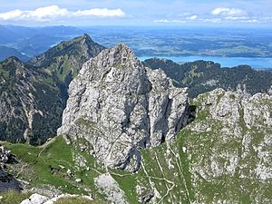
The rocky summit of the Gabelschrofen in the foreground |
||
| height | 1989 m above sea level NN | |
| location | Bavaria , Germany | |
| Mountains | Ammergau Alps | |
| Coordinates | 47 ° 33 '9 " N , 10 ° 49' 26" E | |
|
|
||
| rock | Wetterstein lime | |
| Normal way | From the Gabelschrofensattel through the Südrinne (II) | |
The Gabelschrofen is a 1989 m high mountain in the Ammergau Alps in Bavaria .
The summit can be reached by climbing (II) over the Gabelschrofensattel through a channel. Starting points: Kenzenhütte , Tegelberg mountain station, Bleckenau or Hotel Ammerwald.
The Gabelschrofen is located in the Ammergebirge nature reserve (NSG-00274.01).
Web links
- tourenwelt.info - Entry about the mountain tour
Individual evidence
- ↑ Federal Agency for Cartography and Geodesy , State Office for Surveying and Geoinformation Bavaria : Digital Topographic Map 1:25 000, BayernAtlas , accessed on January 9, 2016
- ↑ protectedplanet.net

