
Kofel
| Kofel | ||
|---|---|---|
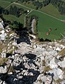
 Kofel with the “calf plate” in the foreground |
||
| height | 1342 m above sea level NN | |
| location | Bavaria , Germany | |
| Mountains | Ammergau Alps | |
| Dominance | 0.53 km → Rappenkopf | |
| Notch height | 105 m | |
| Coordinates | 47 ° 35 '13 " N , 11 ° 3' 35" E | |
|
||
| Normal way | secured path | |

The Kofel is a 1342 m high mountain in the Ammergau Alps . Due to its exposed location and distinctive shape, it can be recognized from afar from the Ammergau and from the direction of Ettal . The summit is only about one kilometer as the crow flies from the center of Oberammergau .
Routes
The direct route starts at the “Döttenbühl” car park near the Oberammergau cemetery at an altitude of 840 meters. After crossing a meadow called “Kälberplatte” with a wonderful view of the imposing destination, you overcome the greatest difference in altitude on a wooded serpentine path to a rain shelter. A secured path to the rocky summit begins from there.
Another possibility of ascent is via the Kolbenalm ( 1040 m ) and the “Königssteig” as a traverse. The Kofel can also be circumnavigated by combining different routes.
Secure climb to the summit
The last hundred meters of altitude are covered via a summit path, which, provided you are sure-footed and free from giddiness , is also suitable for families with children. Steep and exposed sections are secured with fixed steel cables. After rain, there is an increased risk of slipping on heavily worn rocky areas. In Hüsler's via ferrata atlas Alps, the route with difficulty KS1 is rated as a secured route.
If the weather permits, you have an excellent panoramic view around the summit cross, including Ober- and Unterammergau.
Picture gallery

Kofel summit seen from the Kolbenalm
Exposed areas are secured by steel cables

Summit of the Kofel with summit cross

View of Oberammergau with Laber
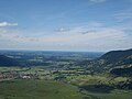
View from the Kofel towards Unterammergau and Altenau

King Ludwig Fire on August 24, 2008: A burning crown on the summit, a burning cross on the Kofelfleck

Temporary light installation "Kofel X" by the artists Sebastian Hertrich and Sebastian Wanke on the summit of the Kofel.


particularities


In 2015 the artists Sebastian Hertrich and Sebastian Wanke installed a light installation on the top of the mountain. The results were presented in 2016 in the exhibition "Made in Oberammergau" in the pavilion of the State College for Wood Sculpture in Oberammergau. A badge was specially designed for the “Kofel X” art campaign and awarded by the artists to those involved and supporters.
Literature and maps
- Dieter Seibert: AVF Allgäu Alps and Ammergau Alps. Rother Verlag Munich 2004, ISBN 3-7633-1126-2
- Compass map WK 05, ISBN 3-85491-481-4
Individual evidence
- ^ Eugen E. Hüsler: Via ferrata atlas Alps. Verlag Bruckmann, 7th edition, Munich 2007, ISBN 978-376544-787-7