
Ochsenälpeleskopf
| Ochsenälpeleskopf | ||
|---|---|---|
 Ochsenälpeleskopf east side (from the Hirschwängalm) |
||
| height | 1905 m above sea level NN | |
| location | Bavaria / Tyrol border | |
| Mountains | Ammergau Alps | |
| Dominance | 0.7 km → Kreuzkopf | |
| Notch height | 137 m ↓ Kuhkarjoch | |
| Coordinates | 47 ° 31 '35 " N , 10 ° 48' 46" E | |
|
||
| Normal way | Ammerwaldhotel - Schützensteig - Ammerwaldsattel - Hirschwängalm - Ochsenälpeleskopf | |

The Ochsenälpeleskopf is a mountain on the German-Austrian border in the Ammergau Alps ( northern Limestone Alps ). The summit is called Hirschfäng or Älpeleskopf on Austrian maps . The associated, lower-lying Ochsenälpele is 1778 m high.
geography
The height of the summit is 1905 m. It can be climbed from both Austria and Germany. From the summit you have a wonderful view of Füssen , the Säuling , the Hohen Straussberg and the Zugspitze massif . Another neighboring peak in the south is the Kreuzkopf (1909 m), which can be reached directly via the Kuhkarjoch .
Fragments of the Neuschwanstein meteorite , which fell on April 6, 2002, were found on the western flank of the Ochsenälpeleskopf in 2002 and 2003 .
ways
The easiest way to the Ochsenälpeleskopf leads via the Ammerwaldhotel and the Schützensteig to the Ammerwaldsattel. From there a hiking trail leads over the Hirschwängalm to the summit.
Picture gallery

Summit of the Ochsenälpeleskopf from the southern flank
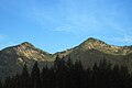
Kreuzkopf (left) and Ochsenälpeleskopf

Summit cross of the Ochsenälpeleskopf; In the background: Füssen and the Hohe Straussberg


Literature and map
- ADAC Wander & RadKarte sheet 55: Füssen, halch, Schwangau, western Ammer Mountains , hiking map 1: 30,000
- Compass (No. 4): Füssen, Ausserfern , hiking map 1: 50,000
Individual evidence
- ↑ Federal Office for Metrology and Surveying : Austrian Map 1: 50,000, AMAP Online , accessed on December 9, 2011