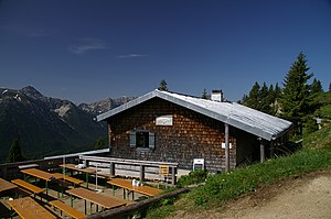
Brunnenkopfhütte
| Brunnenkopfhütte DAV hut category I |
||
|---|---|---|
|
Brunnenkopfhütte |
||
| location | below the well head ; Bavaria , Germany | |
| Mountain range | Ammergau Alps | |
| Geographical location: | 47 ° 34 '54.8 " N , 10 ° 55' 37.8" E | |
| Altitude | 1602 m above sea level NN | |
|
|
||
| owner | DAV - Mountain Country Section | |
| Built | 1856, 1922 | |
| Construction type | Hut; Wood | |
| Usual opening times | May until October | |
| accommodation | 0 beds, 36 camps , 0 emergency camps | |
| Winter room | none | |
| Web link | http://www.dav-bergland.de/brunnenkopfhuette.html | |
| Hut directory | ÖAV DAV | |
The Brunnenkopfhütte ( 1602 m above sea level ) is a mountain hut in the Alps in the Ettal Forest in the Garmisch-Partenkirchen district in the Ammergau Alps . It goes back to the fountain head houses , hunting lodges that King Maximilian II had built in the middle of the 19th century. The hut is registered as an architectural monument in the Bavarian list of monuments.
Accesses
- Linderhof Palace ( 937 m ), walking time: 2 hours
Tour possibilities
Transitions to neighboring huts
- August-Schuster-Haus am Pürschling , walking time: 2½-3 hours
- Kenzenhütte via Klammspitze and Feigenkopf, walking time: 3½ hours
Mountaineering
- Brunnenkopf ( 1718 m ), walking time: 20 minutes
- Große Klammspitz ( 1925 m ), walking time: 1-1½ hours
- Hennenkopf ( 1768 m ), walking time: 1½ hours
- Feigenkopf ( 1866 m ), walking time: 2 hours
Hiking trails
- Hennenkopf - Laubeneck - Teufelstättkopf - Pürschling , walking time: 3 hours
Literature and maps
- Dieter Seibert: AVF Allgäuer Alpen and Ammergauer Alpen , Rother Verlag Munich 2004, ISBN 3-7633-1126-2 .
- Dieter Seibert: Hiking guide around the Zugspitze , Rother Verlag Munich 2006, ISBN 978-3-7633-4264-8 .
- Bavarian land surveying office: topographic map UKL31, Werdenfelser Land , scale 1: 50,000, ISBN 3-86038-509-7 .
- Alpine club map 1: 25,000, sheet BY 7, Ammergebirge East - Pürschling, Hörnle

