
Kramerspitz
| Kramerspitz | ||
|---|---|---|
 Kramerspitz from the northwest |
||
| height | 1985 m | |
| location | Bavaria , Germany | |
| Mountains | Ammergau Alps | |
| Dominance | 6.5 km | |
| Notch height | 780 m ↓ saddle north of the Rotmoosalm | |
| Coordinates | 47 ° 30 '28 " N , 11 ° 2' 52" E | |
|
||
| rock | Main dolomite | |
| Age of the rock | Upper Triassic | |
| Normal way | Garmisch-Partenkirchen - St. Martin - Kramerspitz | |

The Kramerspitz (also called Kramer for short ; translated into High German, but unusual, the Kramerspitze ) is a 1985 m above sea level. NHN high mountain northwest of Garmisch-Partenkirchen . The mountain offers a comprehensive view of the Zugspitze massif as well as the Karwendel mountains and the plain around Munich.
Ascent
The summit can be reached as a mountain tour for sure-footed hikers from Garmisch either via St. Martin (1028 m) or via the Stepbergalm (1583 m) (still visible in the photo at the bottom right).
The mountain is easy to climb for an experienced hiker, only the last 100 meters to the summit require experience in handling climbing aids such as steel ropes, which are attached to difficult places. Since the last 100 meters of altitude consist of bare rock, you should be particularly careful in the winter months.
There are several ways to climb it, a very popular one leads over the foot of the mountain, e.g. B. at the sports field in Garmisch-Partenkirchen, via the circular route to the Stepbergalm (ascent approx. 2-3 hours). From the Stepbergalm it is about 400 meters in altitude to the actual summit (approx. 1–2 hours). On the descent, you can climb two other secondary peaks before you return to the starting point after a 2–3 hour descent.
Picture gallery

Ascent Kramer, view from the St. Martinshütte towards Garmisch-Partenkirchen

Ascent Kramer with a view towards Garmisch-Partenkirchen; slightly above the St. Martinshütte

Ascent Kramer, view from the Felsenkanzel (1238 m) towards the Zugspitze

View from the Kramergrat in east direction to Garmisch-Partenkirchen

View from the Kramergrat in west direction to the Kramer summit

Kramerspitz summit area, from the Stepbergalm
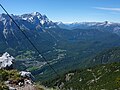
View from Kramerspitz towards Zugspitze, with Grainau and Eibsee

Kramerspitz summit (real summit, summit cross is approx. 5 meters below)

Kramerspitz summit from the north

Stepbergalm in winter

Garmisch, pedestrian zone with the Kramerspitz in the background


Structural interventions
Garmisch-Partenkirchen is located immediately southeast of the Kramerspitz. As part of a planned bypass , the Kramer tunnel is currently under construction, the route of which runs through the southern slope of the mountain.
literature
- Dieter Seibert: AVF Allgäu Alps and Ammergau Alps. Rother Verlag, Munich 2004, ISBN 3-7633-1126-2 .
Web links
Individual evidence
- ↑ Geological map of Bavaria with explanations (1: 500,000). Bavarian Geological State Office, 1998.
- ↑ Federal Office for Cartography and Geodesy , State Office for Surveying and Geoinformation Bavaria : Digital Topographical Map 1:25 000, [1] , accessed on July 7, 2012