
Bad Kohlgrub
| coat of arms | Germany map | |
|---|---|---|

|
Coordinates: 47 ° 40 ' N , 11 ° 3' E |
|
| Basic data | ||
| State : | Bavaria | |
| Administrative region : | Upper Bavaria | |
| County : | Garmisch-Partenkirchen | |
| Height : | 828 m above sea level NHN | |
| Area : | 32.58 km 2 | |
| Residents: | 2854 (Dec. 31, 2019) | |
| Population density : | 88 inhabitants per km 2 | |
| Postal code : | 82433 | |
| Area code : | 08845 | |
| License plate : | Cap | |
| Community key : | 09 1 80 112 | |
| LOCODE : | DE BE9 | |
| Community structure: | 18 parts of the community | |
| Address of the municipal administration: |
Hauptstrasse 29 82433 Bad Kohlgrub |
|
| Website : | ||
| First Mayor : | Franz Degele ( Free Association of Voters ) | |
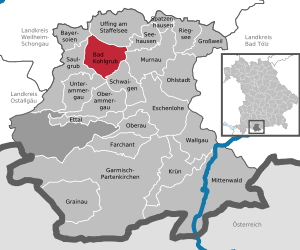
| Location of the municipality of Bad Kohlgrub in the Garmisch-Partenkirchen district | ||
  |
||


Bad Kohlgrub is a municipality in the Upper Bavarian district of Garmisch-Partenkirchen . The place is the highest moor spa in Germany. The entire place has been documented as a spa since 1948, the district of Gagers (today's Upper Spa Area) since 1878.
geography
The community lies in the Oberland region of 800-900 meters above sea level at the foot of the Ammergau Alps belonging Hörnle . About eight kilometers east of the village is the Staffelsee and the Murnauer Moos . Numerous hamlets belong to the place . The community is located in the Ammergau Alps Nature Park .
There are 18 officially named parts of the municipality (the type of settlement is given in brackets ):
|
|
history

Until the church is planted
Bad Kohlgrub belonged temporarily to the Ettal Abbey and temporarily to the Rottenbuch Abbey until 1803 , but actually formed its own Hofmark Kohlgrub. Ettal also exercised high jurisdiction in the Hofmark . In the course of the administrative reforms in the Kingdom of Bavaria , the municipality edict of 1818 created today's municipality, which belonged to the Schongau district court .
The place name is originally traced back to the charcoal industry, which means that charcoal was burned in piles there.
In 1663 only two families survived the plague . From this arose the vow of these families to build a church if they survived this stroke of fate. The Rochus Church, named after the plague saint, St. Rochus, bears witness to this. It stands north of the village on a hill, but in the expanded Baroque form from 1733. B. also the Oberammergau Passion Play .
19th century
The place first entered history as a “bath” in 1871, when such a facility was built and approved around the local steel springs in the Gagers district . The place only became a mud spa after they had dried up. The healing power of the surrounding high moor against gout, sciatica, gynecological problems and the like was known to the locals for a long time.
20th century
In 1913, the community was reclassified from the Schongau district office to what was then the Garmisch district office .
Since July 13, 1948, the place can use the title "Bad" in the place name.
Population development
Between 1988 and 2018 the municipality grew from 1,986 to 2,841 by 855 inhabitants or 43.1% - the highest percentage increase in the district in the period mentioned. The place has developed into an attractive place to live, especially for young families due to the existing good infrastructure (crèche and kindergarten, elementary and middle school, sports and leisure opportunities, clubs).
- 1970: 1975 inhabitants
- 1991: 2154 inhabitants
- 1995: 2260 inhabitants
- 2000: 2261 inhabitants
- 2005: 2420 inhabitants
- 2010: 2531 inhabitants
- 2015: 2689 inhabitants
politics
mayor
Since August 1, 2018, the first mayor has been the previous second mayor, Franz Degele. Before that, Karl-Heinz Reichert from Palatinate was the First Mayor from May 1, 2014 to July 31, 2018. On the basis of his application, the municipal council had put him into retirement due to illness.
tax income
The municipal tax income totaled 2.75 million euros in 2014, of which the trade tax income (net) amounted to the equivalent of 220,000 euros.
coat of arms
The description of the coat of arms reads: Above a blue shield base, inside a golden wooden bathtub separated by two silver corrugated strips, split by gold and silver; at the front of the gap a half, red armed black eagle, behind a rooted, seven-leaf red beech.
The coat of arms dates from 1968.
Significance: For the local history the close connection with the monasteries Ettal and Rottenbuch due to the manorial property is important, for the present of the community the character of the place as a spa, which in turn can look back on a long development. The symbol for “BAD” (tub and waves) is therefore associated with the characteristics of the Ettal monastery, which dates back to the founding of Emperor Ludwig of Bavaria (half imperial eagle) and the Rottenbuch monastery (beech as a talking coat of arms).
Culture and sights
Buildings
The parish church of St. Martin is located in the center of Bad Kohlgrub. Most of the interior is rococo . The Rochus Chapel was built after the plague in 1633/34 on what was then the plague cemetery and is dedicated to the plague saint St. Rochus. The Rochus Chapel is only freely accessible to visitors up to a partition in the anteroom.
nature
The Hörnle is the local mountain of the community. It is the starting point for hiking, skiing and tobogganing. The "Zeitberg" has existed on the Hörnle since 2013. Six islands of calm invite you to switch off and pause.
Regular events
The Ammergau Alps Classic Days have been held annually in September since 2015. This festival for classical music is organized by Beate and Josef Gilgenreiner (artistic directors) and offers a wide range of events (concerts, readings, workshops and exhibitions) for children and adults.
The musician couple Hertha and Wilhelm Keilmann have performed regularly with violin concertos and string quartets since 1952.
Economy and Infrastructure
Tourism and tourism
The municipality of Bad Kohlgrub is part of the Ammergau Alps tourist region . The region is represented in terms of tourism by the Ammergauer Alpen GmbH. In addition to Bad Kohlgrub, the Ammergau Alps nature park region includes the villages of Unterammergau , Bad Bayersoien , Oberammergau , Ettal / Graswang / Linderhof and Saulgrub / Altenau / Wurmansau.
Bad Kohlgrub has about 2500 guest beds, about half of which are in holiday apartments. In 2018, more than 185,000 overnight stays and almost 56,000 arrivals were counted. Commercial tourism companies (hotels, guest houses, rehabilitation clinics, sanatoriums) provide almost 80% of the jobs.
The basis for tourism is health care. Bad Kohlgrub is known for high moor mountain pine applications, and the moor / peat provided for balneology is one of the best-researched peats.
The Hörnlebahn, a two- seater chairlift , leads from Bad Kohlgrub to the Hörnle.
Economy including agriculture and forestry
In 1998 there were no employees in the field of agriculture and forestry, 87 in the manufacturing sector and no employees in the field of trade and transport at the place of work. In other economic sectors 419 people were employed at the place of work subject to social security contributions. There were a total of 663 employees at the place of residence subject to social security contributions. There were six companies in the manufacturing sector and three in the construction sector.
In addition, in 1999 there were 69 farms with an agricultural area of 1254 ha.
traffic
Bad Kohlgrub is located on the Ammergaubahn Murnau - Oberammergau , which is operated every hour .
The place can be reached by car via State Road 2062 Saulgrub – Murnau.
education
The following institutions existed in 2014:
- Kindergartens: 80 kindergarten places
- a primary and a middle school with around 15 teachers and 220 students.
- a forest kindergarten with an average of twelve children
Personalities
- Johann Baptist Schott (1853–1913), architect, born in the Schönau district
- Eugen Schilling (1861–1941), chemist
- Heinrich Bulle (1867–1945), archaeologist
- Wilhelm Keilmann (1908–1989), pianist and composer
- Martin Lindauer (1918–2008), behavioral scientist
- Gisela Schlüter (1914–1995), cabaret artist and actress
- Hans Hubberten (1929–1988), screenwriter
- Otto A. Schwimmbeck (born June 4, 1945), entrepreneur
- Anian Christoph Wimmer (born May 4, 1973), journalist, publicist and author
See also
Web links
- Homepage of the Bad Kohlgrub community
- Entry on the coat of arms of Bad Kohlgrub in the database of the House of Bavarian History
Individual evidence
- ↑ "Data 2" sheet, Statistical Report A1200C 202041 Population of the municipalities, districts and administrative districts 1st quarter 2020 (population based on the 2011 census) ( help ).
- ^ Community of Bad Kohlgrub: Greetings from the mayor. Retrieved May 24, 2020 .
- ↑ History ( Memento of the original from April 6, 2009 in the Internet Archive ) Info: The archive link was inserted automatically and has not yet been checked. Please check the original and archive link according to the instructions and then remove this notice. History of the place
- ^ Community Bad Kohlgrub in the local database of the Bavarian State Library Online . Bayerische Staatsbibliothek, accessed on September 6, 2019.
- ↑ AmmerWiki for Bad Kohlgrub ( Memento of the original dated February 2, 2013 in the Internet Archive ) Info: The archive link was inserted automatically and has not yet been checked. Please check the original and archive link according to the instructions and then remove this notice.
- ↑ Bavarian State Statistical Office (Hrsg.): Historical municipality register: The population of the municipalities of Bavaria in the period from 1840 to 1952 (= contributions to Statistics Bavaria . Issue 192). Munich 1954, DNB 451478568 , urn : nbn: de: bvb: 12-bsb00066439-3 . , P. 27
- ^ Wilhelm Volkert (ed.): Handbook of Bavarian offices, communities and courts 1799–1980 . CH Beck, Munich 1983, ISBN 3-406-09669-7 , p. 469 .
- ↑ Coat of arms of the Bad Kohlgrub community ( Memento of the original from April 6, 2009 in the Internet Archive ) Info: The archive link has been inserted automatically and has not yet been checked. Please check the original and archive link according to the instructions and then remove this notice. Bad Kohlgrub municipality
- ^ Rochus Chapel Bad Kohlgrub. Retrieved January 24, 2020 .
- ^ Website of the Hörnlebahn

Bad Bayersoien | Bad Kohlgrub | Eschenlohe | Ettal | Farchant | Garmisch-Partenkirchen | Grainau | Großweil | Krün | Mittenwald | Murnau am Staffelsee | Oberammergau | Oberau | Ohlstadt | Riegsee | Saulgrub | Schwaigen | Seehausen am Staffelsee | Sparrow House | Uffing am Staffelsee | Unterammergau | Wallgau
Unregulated areas: Ettaler Forst