
High goatskin
| High goatskin | ||
|---|---|---|
 Hoher Ziegspitz from the north with the Zugspitze in the background |
||
| height | 1864 m | |
| location | Bavaria , Germany | |
| Mountains | Ammergau Alps | |
| Coordinates | 47 ° 30 '8 " N , 11 ° 0' 14" E | |
|
||
| Age of the rock | Main dolomite from the Upper Triassic | |
| Normal way | Garmisch-Partenkirchen - Stepbergalpensteig - Stepbergalm - Hoher Ziegspitz | |

The Hohe Ziegspitz is a 1,864 m high mountain in the Ammergau Alps , Bavaria . It forms the western end point of the Kramer group . Its name is not derived from goat , but from so-called trains , which are used to denote avalanche lines (see Zugspitze ).
Location and surroundings
The Hohe Ziegspitz is about seven kilometers as the crow flies west of Garmisch-Partenkirchen and forms the westernmost peak of the Kramer group . To the southwest, a ridge runs to the secondary peaks Rauhenstein ( 1728 m ) and the high Rauheck ( 1636 m ). To the northeast the ridge continues to the 1815 m high Vorderen Ziegspitz . Above the tree line , which is around 1500 m here , the Hohe Ziegspitz is characterized by grass slopes and mountain pines , while rocky terrain dominates in the area of the west ridge to the Rauheck. To the south is the Zunderköpfl.
Development
The summit can be reached as a simple mountain hike from Garmisch-Partenkirchen , with the ascent leading over the northeastern Stepbergalm ( 1583 m ). Another ascent runs from the Rotmoosalpe to the west over the Vorderen Ziegspitz to the summit.
map
- Alpine Club Map 1: 25,000, Sheet BY7, Ammer Mountains East

Hoher Ziegspitz in winter from Grainau

Summit cross of the Hohen Ziegspitz, erected in 1975
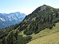
Hoher Ziegspitz, from the ascent path, in the background the Zugspitze massif


Individual evidence
- ^ Historischer Verein von Oberbayern, Oberbayerisches Archiv , Volumes 62–63, 1921, p. 162
- ↑ Dieter Seibert: Alpine Club Guide Allgäu Alps and Ammergau Alps , Rother Verlag Munich 2008, ISBN 9783763311262 , p. 444