
Dickelschwaig
|
Dickelschwaig
Ettal municipality
Coordinates: 47 ° 34 '10 " N , 11 ° 1' 55" E
|
|
|---|---|
| Height : | 865 m above sea level NHN |
| Postal code : | 82488 |
| Area code : | 08822 |
 |
|
Dickelschwaig is a district of the Upper Bavarian municipality of Ettal in the Garmisch-Partenkirchen district .
location
The wasteland is about 5 km west of Ettal and about 500 m southeast of Graswang in the Graswangtal south of the Linder and the state road 2060 at the northern foot of the Kieneckspitz at an altitude of 867 m above sea level. NHN .
Townscape
Dickelschwaig consists only of a former forester's house, which in its core probably dates back to the 17th century, which now serves as an agricultural property, and a hexagonal chapel with an onion dome built in 1694. The buildings are surrounded by wide meadows that pull up the slope. There are only a few trees near the buildings.
Attractions
See also: List of architectural monuments in Ettal # Dickelschwaig
- Forest house Dickelschwaig
- St. Gertrudis Chapel or Dickelschwaig Chapel
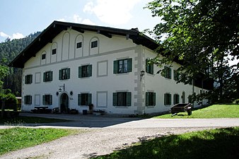
Forest house Dickelschwaig
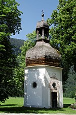
Gertrudiskapelle


Web links
- Dickelschwaig in the location database of the Bavarian State Library Online . Bavarian State Library
Individual evidence
- ↑ Dickelschwaig. In: BayernAtlas of the Bavarian State Government ( information ). Retrieved September 5, 2019 .