Linder (river)
| Linder | ||
|
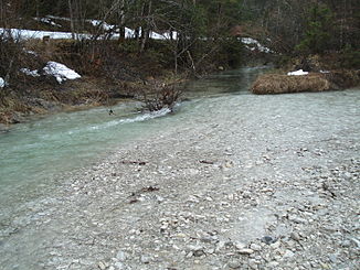
The dry river bed of the Linder east of Graswang, before the Ammer emerges again . |
||
| Data | ||
| Water code | EN : 164 | |
| location | Bavaria , Germany | |
| River system | Danube | |
| Drain over | Ammer → Amper → Isar → Danube → Black Sea | |
| confluence | from Fischbach and Neualmbach , southwest of Linderhof Palace 47 ° 32 ′ 14 ″ N , 10 ° 53 ′ 24 ″ E |
|
| Source height | approx. 1090 m above sea level NHN | |
| muzzle | at the Großer Ammerquellen in the Ammer coordinates: 47 ° 34 ′ 4 ″ N , 11 ° 3 ′ 5 ″ E 47 ° 34 ′ 4 ″ N , 11 ° 3 ′ 5 ″ E |
|
| Mouth height | approx. 850 m above sea level NHN | |
| Height difference | approx. 240 m | |
| Bottom slope | approx. 18 ‰ | |
| length | 13.5 km (with Fischbach 16.6 km) | |
| Right tributaries | Kühalpenbach | |
|
The Linder (right) flows into the brook from the Große Ammerquellen (rear) and from there bears the name Ammer |
||

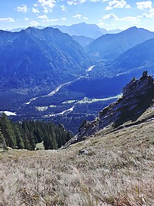
The Linder is a small mountain river southwest of Oberammergau in Upper Bavaria . It forms the upper course of the Ammer , which later flows into the Ammersee and flows into the Isar as the Amper .
geography
course
The Linder arises southwest of Linderhof Castle from the confluence of Fischbach and Neualmbach , both of which form the border between Germany and Austria at this point . After the two streams have merged, the Linder is still fed by the seven springs . It flows northeast through the Graswang valley and crosses under State Road 2060 to the north before Linderhof and to the south just before Graswang .
For a large part of the year, the Linder water seeps away into the karst subsoil between Linderhof and Graswang and reappears in the spring pots of the Großer Ammer and Kleiner Ammer and in the lower reaches of the Kohlbach to the east of Graswang in the Weidmoos . During floods and after the snow has melted, the Linder also reaches the Weidmoos above ground. The drains from the Große Ammerquellen then flow from the right and left into the often larger Linder, which from there bears the name Ammer .
Tributaries
- Fischbach (left source stream)
- Neualmbach (right source stream)
- Hochries (right)
- Stockgraben (left)
- Gamsangerlahne (right)
- Scheinberggraben (left)
- Lotterslahne (right)
- House slab (right)
- Dog ditch (left)
- Sägertalbach (left)
- Martinsgraben (left)
- Dreisäuler Bach (left)
- Lindergraben (left)
- Erzgraben (left)
- Höllgraben (right)
- Elmaubach (right)
- Karlegraben (right)
- Kühalpenbach (right)
history
The course of the Linder was partially expanded in the 20th century. The tributaries in particular were diverted at the foot of the slope shortly before the confluence with the Linder. The course of the Linder was and is in the upper reaches to Graswang a typical relocation stretch , in which the river can change its bed in a largely natural rhythm and thereby relocate the gravel areas. Hydraulic engineering measures in the Grießen itself have led to a considerable loss of space in the open gravel stretches and probably also in flood plains. The Linder originally seeped away at about Graswang in a rubble fan that reached about a kilometer to the east and connected to the Kohlbach coming from the west . Most of the runoff from the entire semolina was underground. Surface runoff of the water only occurred during floods. This flowed either directly north into the Kohlbach or further through the semolina to the east and then into the lower course of the Kohlbach, where the Kühalpenbach flowing in from the south also flows. The Linder flowed in today's course of the Kohlbach. At the beginning of the 20th century, the entire drainage route was connected like a canal to a source stream of the Ammer, which no longer exists today.
Web links
- Map of the course and catchment area of the Linder on: BayernAtlas of the Bavarian State Government ( information )
Individual evidence
- ↑ a b c Google Earth
- ↑ LBV Upper Bavaria. Archived from the original ; accessed on March 18, 2019 .
- ^ Original position sheet 863: Ettal and the surrounding area in 1831 on the Bavaria Atlas

