
Little bunting
|
Kleine Ammer ( Historically : Kleine Amper ) |
||
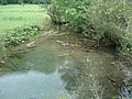
 The little bunting in Weidmoos |
||
| Data | ||
| location | Bavaria , Germany | |
| River system | Danube | |
| Drain over | Ammer → Amper → Isar → Danube → Black Sea | |
| source | in the Kleine Ammerquellen 47 ° 34 '32 " N , 11 ° 3' 36" E |
|
| Source height | approx. 850 m above sea level NHN | |
| muzzle | in the Ammer coordinates: 47 ° 34 ′ 58 " N , 11 ° 4 ′ 22" E 47 ° 34 ′ 58 " N , 11 ° 4 ′ 22" E
|
|
| length | approx. 3 km | |
The Kleine Ammer is a left tributary of the Ammer south of Oberammergau in Upper Bavaria .
geography
course
In the source funnels the little Ammer sources in Weidmoos east of cream for the most part the waters of the west seepage occurs Linder to light again. In about 30 spring pots, in which you can see rising bubbles, small spring streams arise, which flow together after a few meters.
The runoff from the western springs was artificially diverted to the southeast as a mill stream . It crosses the river bed of the still young Großer Ammer by means of a culvert , drives a turbine in the Ettaler Mühle and flows into the Große Ammer from the right.
The Kleine Ammer rises from the eastern spring pots and meanders below the Falkenwand on the Rappenkopf (1408 m) . Opposite the Bear Cave, it flows about 130 meters down the mouth of the Mühlbach from the left into the Große Ammer and forms the Ammer with it .
Web links
Individual evidence
- ↑ Bayernviewer of the Bavarian Surveying Administration: Historical maps from the years 1817–1841 ( Memento of the original from August 8, 2014 in the Internet Archive ) Info: The archive link was inserted automatically and has not yet been checked. Please check the original and archive link according to the instructions and then remove this notice.
- ↑ Google Earth
Picture gallery
Spring pot of the Kleine Ammerquellen
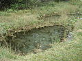
Small spring funnel in the Weidmoos

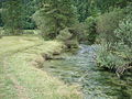
Confluence of two source streams (in the background the houses of Rahm)
The Kleine Ammer in Weidmoos

The small bunting (at the back) joins the bunting


