
Administrative community Unterammergau
| coat of arms | Germany map | |
|---|---|---|

|
Coordinates: 47 ° 37 ' N , 11 ° 2' E |
|
| Basic data | ||
| State : | Bavaria | |
| Administrative region : | Upper Bavaria | |
| County : | Garmisch-Partenkirchen | |
| Area : | 44.68 km 2 | |
| Residents: | 2343 (Dec. 31, 2019) | |
| Population density : | 52 inhabitants per km 2 | |
| License plate : | Cap | |
| Association key : | 09 1 80 5135 | |
| Association structure: | 2 municipalities | |
| Association administration address : |
Dorfstrasse 23 82497 Unterammergau |
|
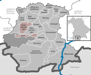
| Location of the Unterammergau administrative community in the Garmisch-Partenkirchen district | ||
  |
||

The Unterammergau administrative community is located in the Upper Bavarian district of Garmisch-Partenkirchen and is formed by the following communities:
- Ettal , 758 inhabitants, 14.75 km²
- Unterammergau , population 1585, 29.93 km²
The administrative association is based in Unterammergau.
history
When the municipal reform came into force on May 1, 1978, the Oberammergau administrative community was formed, to which the three municipalities of Oberammergau , Unterammergau and Ettal belonged. The seat of the administrative community was the eponymous municipality of Oberammergau.
On January 1st, 1980 Oberammergau was released from the administrative community, at the same time the relocation of the seat and the renaming took place.
Individual evidence
- ↑ "Data 2" sheet, Statistical Report A1200C 202041 Population of the municipalities, districts and administrative districts 1st quarter 2020 (population based on the 2011 census) ( help ).
- ↑ Law of August 10, 1979 (GVBl p. 223)
Ohlstadt | Saulgrub | Seehausen a.Staffelsee | Unterammergau
Dissolved: Bad Kohlgrub | Krün | Oberammergau