
Saulgrub administrative community
| coat of arms | Germany map | |
|---|---|---|

|
Coordinates: 47 ° 40 ' N , 11 ° 2' E |
|
| Basic data | ||
| State : | Bavaria | |
| Administrative region : | Upper Bavaria | |
| County : | Garmisch-Partenkirchen | |
| Area : | 53.15 km 2 | |
| Residents: | 2878 (Dec. 31, 2019) | |
| Population density : | 54 inhabitants per km 2 | |
| License plate : | Cap | |
| Association key : | 09 1 80 5133 | |
| Association structure: | 2 municipalities | |
| Association administration address : |
Kohlgruber Str. 2 82442 Saulgrub |
|
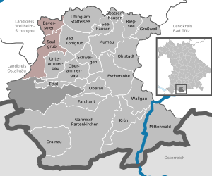
| Location of the Saulgrub administrative community in the Garmisch-Partenkirchen district | ||
  |
||

The Saulgrub administrative community is located in the Upper Bavarian district of Garmisch-Partenkirchen and is formed by the following communities:
- Bad Bayersoien , population 1221, 17.67 km²
- Saulgrub , 1657 inhabitants, 35.48 km²
The administrative association is based in Saulgrub.
Originally, the community also belonged to the Bad Kohlgrub community , which gave it its name and was the seat of the corporation. Bad Kohlgrub was released from the administrative community on January 1, 1980, and the headquarters were moved and renamed at the same time.
Individual evidence
- ↑ "Data 2" sheet, Statistical Report A1200C 202041 Population of the municipalities, districts and administrative districts 1st quarter 2020 (population based on the 2011 census) ( help ).
- ↑ Law of August 10, 1979 (GVBl p. 223)
Administrative communities in the Garmisch-Partenkirchen district
Ohlstadt | Saulgrub | Seehausen a.Staffelsee | Unterammergau
Dissolved: Bad Kohlgrub | Krün | Oberammergau