
Peiting
| coat of arms | Germany map | |
|---|---|---|

|
Coordinates: 47 ° 48 ' N , 10 ° 56' E |
|
| Basic data | ||
| State : | Bavaria | |
| Administrative region : | Upper Bavaria | |
| County : | Weilheim-Schongau | |
| Height : | 718 m above sea level NHN | |
| Area : | 75.14 km 2 | |
| Residents: | 11,425 (Dec. 31, 2019) | |
| Population density : | 152 inhabitants per km 2 | |
| Postal code : | 86971 | |
| Area code : | 08861 | |
| License plate : | WM, SOG | |
| Community key : | 09 1 90 140 | |
| LOCODE : | DE PTG | |
| Market structure: | 40 parish parts | |
Market administration address : |
Hauptplatz 2 86971 Peiting |
|
| Website : | ||
| Mayor : | Peter Ostenrieder ( CSU ) | |
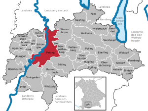
| Location of the Peiting market in the Weilheim-Schongau district | ||
  |
||


Peiting is a market in the Upper Bavarian district of Weilheim-Schongau .
Surrounded by the moraine hills Schlossberg, Kalvarienberg , Schnaidberg and Bühlach, Peiting is a place that, despite the increase in population after the Second World War , was able to retain its Bavarian village character. Numerous farms are located outside the town center in various hamlets . The place name is probably derived from the noble family of Peuting , who probably settled in the local area as early as the 6th century. The place is historically significant as the headquarters of the Guelphs who once lived here .
The Herzogsägmühle settlement , a Diakonie facility , also belongs to the municipality of Peiting .
geography
location
Peiting is located in the Oberland region to the east of Schongau near the east bank of the Lech , which the municipality actually borders only southwest of federal highway 17 in an unpopulated area. The Peitinger Mühlbach (also called Peitnach) flows through the local area in a northerly direction and flows into the Lech in the municipality near Lech barrage 7.
Community structure
Markings
- Birkland
- Peiting
- Hohenbrand
Parish parts
The municipality has 40 officially named municipal parts (the type of settlement is given in brackets ):
|
|
|
dialect
Although Peiting belongs politically to the administrative district of Upper Bavaria , no typical (Middle) Bavarian is spoken in the village , but the Lechrain dialect , which combines Bavarian and Alemannic language elements and is characteristic of the area immediately east of the Lech .
history
Until the church is planted


Finds of first settlement on the east bank of the Lech go back to the third millennium BC. The earliest finds are a stone ax and pottery shards. There are Bronze Age graves on the Bühlachberg, and Celts and Romans also left traces. In Roman times there was a large manor with many outbuildings on the "Neukirchwiesen". After the Romans, the Alemanni settled the area.
The first documentary mention of Peiting was in 1055 as the "new" Peiting Castle of the Welfs who lived here . The Welfenburg was located on the Schlossberg and was the focus of all actions of the Lechrainer Welfen. These Guelphs also took part in crusades and founded the Rottenbuch and Steingaden monasteries . The Peitinger Guelph line died out in 1191. The last of this line was Welf VI. The Welfenburg partially collapsed due to an earthquake in 1348. In 1438 Peiting was granted market rights by the Bavarian Duke Ernst . The city of Schongau saw itself by this exposure of Peiting in "their freedoms" and asked the Duke to deny the Peitingers the market rights again. The request was rejected, and Duke Albrecht confirmed the Peitingern market rights again in 1455. In 1490 the Peitinger Market Court was merged with the city of Schongau. In the Thirty Years War , in 1632, the Welfenburg was completely destroyed by the Swedes. At the same time, the "hot fever" (probably typhus ) broke out, from which around 400 people died in Peiting in 1632. In both the War of the Spanish Succession and the War of the Austrian Succession , enemy troops attacked Peiting, plundered and pillaged it.
In the course of the administrative reforms in Bavaria in 1818, Peiting became an independent political municipality that belonged to the Schongau district court .
20th century
After the end of the First World War , a coal mine was built in Peiting . After 1945 1,500 displaced persons came to Peiting as refugees. In 1957, the Peiting coal mine had its highest workforce with 882 miners and 47 employees. In 1958 the then largest village in Upper Bavaria was again given formal market rights . In 1968 the mine was closed. A brief economic crisis followed. New businesses quickly settled.
Incorporations
On January 1, 1976, the previously independent municipality of Birkland was incorporated as part of the regional reform .
Population statistics
Between 1988 and 2019 the market grew from 10,316 to 11,425 by 1,109 inhabitants or 10.8%.

|
|
Denomination statistics
In the 2011 census , 67.5% of the population stated to be Roman Catholic , 12.0% Protestant and 20.5% were non-denominational , belonged to another religious community or did not provide any information. The number of Protestants, and especially Catholics, has decreased since then. At the end of 2019, Peiting had 11,713 inhabitants, of which 59.7% were Catholics, 10.5% Protestants and 29.7% had either another religion or no religion.
politics
City council and mayor
| Party / list | 2020 election | Election 2014 | 2008 election | Election 2002 | |||||
|---|---|---|---|---|---|---|---|---|---|
| % | Seats | % | Seats | % | Seats | % | Seats | ||
| SPD | 21.2 | 5 | 40.4 | 10 | 46.4 | 11 | 40.7 | 10 | |
| CSU | 26.2 | 6th | 28.9 | 7th | 36.5 | 9 | 43.3 | 11 | |
| Citizens' Association Peiting | 22, 8 | 6th | 23.6 | 5 | 17.1 | 4th | 12.9 | 3 | |
| Alliance 90 / The Green Bavaria | 11.9 | 3 | 7.1 | 2 | - | - | - | - | |
| Independent Peitinger (UP) | 13.8 | 3 | - | - | - | - | - | - | |
| ödp | 4.1 | 1 | - | - | - | - | - | - | |
| German party | - | - | - | - | - | - | 3.1 | - | |
| total | 100 | 24 | 100 | 24 | 100 | 24 | 100 | 24 | |
| voter turnout | 65.0% | 57.9% | 65.6% | 62.3% | |||||
Michael Asam (SPD) has been mayor since 1996. In the 2014 local elections, he was once again confirmed in office with 81.1% of the valid votes. He was followed in 2020 by Peter Ostenrieder (CSU), who was elected in the runoff election on March 29, 2020 with 56.1% of the valid votes. His competitor Annette Luckner (SPD) received 43.9% of the vote.
Community finances
In 2017, the municipal tax revenue was € 13,189,000, of which € 5,226,000 was trade tax revenue (net).
coat of arms
In 1438, Duke Ernst Peiting gave the town its own coat of arms, the Wittelsbach diamond coat of arms with a sloping, red crossbar. It was only the fourth award of the coat of arms to one place in Bavaria.
The white and blue diamonds indicate, on the one hand, the constant affiliation with old Bavaria and, on the other hand, the close relationship between the community and the Wittelsbach family. The red oblique left bar may have been useful to distinguish it from the sovereign diamond coat of arms. The design follows the description handed down in the coat of arms privilege of 1438. The coat of arms was awarded by Duke Ernst of Bavaria, as well as market freedom.
With ministerial permission, the municipality was allowed to use the historical coat of arms again in 1836, but it was forgotten again.
From then on, the depiction of the coat of arms was based on a tradition on a glass window in the Maria Egg chapel (Maria unter der Egg) and on the veteran flag.
partnership
Economy and Infrastructure
In 1998 there were a total of 3,674 employees at the place of residence subject to social insurance contributions. There were no companies in the manufacturing sector and 14 in the construction sector. In addition, in 1999 there were 135 farms with an agriculturally used area of 3488 ha. 185 ha of this were arable land and 3293 ha were permanent green areas.
Public facilities
There are the following institutions (as of 2015):
- Kindergartens: 388 kindergarten places
- Elementary schools: three with 45 teachers and 897 students
- Peitinger wave swimming pool with volleyball court and playground
traffic
Peiting is the junction of three federal highways. The B 472 runs from Irschenberg via Bad Tölz to Marktoberdorf in an east-west direction. The B 17 runs from Augsburg to Füssen in a north-south direction. The B 23 is the fastest connection from Peiting to Garmisch-Partenkirchen and on to the border crossing to Scharnitz in Tyrol. Until the beginning of the 1990s, the residents suffered from traffic jams and traffic noise, but today the town center can be bypassed on the well-developed bypass.
There are two train stations in Peiting on the Schongau – Peißenberg railway line :
- the Peiting Ost train station ,
- as well as the Peiting Nord stop
Diesel multiple units of the Bavarian Regiobahn operate on this route every hour . During the mining period, the mine had its own siding, which other companies continued to use until 2005 after the dismantling was completed. In addition, there was a narrow-gauge railway from Peiting Ost to the peat factory in the Schwarzlaichmoor until the 1950s .
Culture and sights
Museums
- Museum in the Klösterle
- Villa Rustica Peiting
Buildings
- The 66 m high Rottenbuch radio tower was at the time of its construction (2002) the tallest wooden tower in Germany.
- The local wind turbine was built on the Bühlach despite many protests and is operated by a private investor community.
See also: List of architectural monuments in Peiting and List of ground monuments in Peiting
Others
- Coal seam on Bühlach (one of the "most beautiful geotopes in Bavaria" )
Personalities
Honorary citizen
- Michael Zieglmeier (1874–1959), Senior Mountain Director
- Karl Fliegauf, former mayor and local chronicle; in office from 1954 to 1978
- Michael Dacher (1933–1994), extreme mountaineer
Sons and daughters of the church
- Placidus Braun (1756–1829), German church historian
- Martin Erhard (1918–2017), trade unionist and politician
- Karl Werner (1956-2007), entomologist
- Hubert Filser (1959–2012), Roman Catholic theologian and dogmatist
- Christine Echtler-Schleich (* 1963), ski mountaineer
- Josef Holzmann (* 1964), racing cyclist
- Martin Echtler (* 1969), mountaineer and alpine athlete
- Markus Gleich (* 1987), ice hockey player
Personalities associated with the place
- Günther Neureuther (born August 6, 1955), two-time Olympic medalist in judo; lives in Peiting
Others
- Catholic rural youth Peiting
- Judo department
- Ice hockey club EC in TSV Peiting
- Football club FA Peiting
- Peiting fishing association
- The moor near Peiting is where the 1000 year old Ms. von Peiting , also called "Rosalinde", was found.
- Connection to numerous mapped cycle paths , z. B. the König-Ludwig-Radweg
- The men of the SKV Blau-Weiß Peiting bowling club played in the bowling league (Classic) in the “120 litter” system from 2002–2019 , and in the first division from 2009–2015.
literature
- Karl Fliegauf: Chronicle of the community of Peiting in five volumes
- Georg Urban Bucher: Documentary contributions to the history of the village and the parish of Peitingen . In: Upper Bavarian Archive for Fatherland History (Historischen Verein von Oberbayern, ed.), Volume 4, Munich 1843, pp. 147-218 ( online ).
Web links
- Official website of the municipality
- Entry on the coat of arms of Peiting in the database of the House of Bavarian History
- Peiting: Official statistics of the LfStat (PDF; 1.24 MB)
Remarks
- ↑ "der Gumpen" or "der Peitinger Gumpen" is the proper name of the body of water and does not mean that it is a Gumpen .
Individual evidence
- ↑ "Data 2" sheet, Statistical Report A1200C 202041 Population of the municipalities, districts and administrative districts 1st quarter 2020 (population based on the 2011 census) ( help ).
- ↑ Cf. The Peutinger family - Ministrale of the Welfs. In: Karl Fliegauf: Chronicle of the community Peiting. Volume 1, page 159 ff.
- ^ Parish Peiting in the local database of the Bavarian State Library Online . Bayerische Staatsbibliothek, accessed on September 4, 2019.
- ↑ a b Georg Paula , Stefanie Berg-Hobohm : District Weilheim-Schongau: Monuments in Bavaria. Karl M. Lipp Verlag, Munich 2003, Volume 1, Page 238
- ↑ a b c Markt Peiting. In: The district of Weilheim-Schongau. Published by: District Office Weilheim-Schongau 2010, texts: Max Biller (district archivist), Helmut Schmidbauer (district home administrator), pages 65 to 69
- ^ Peiting and Schongau (Altenstadt) under the Welfs (1050–1200) , Historical Association of and for Upper Bavaria, Munich 1920, page 4
- ^ Peiting and Schongau (Altenstadt) under the Welfs (1050–1200) , Historical Association of and for Upper Bavaria, Munich 1920, page 8 f.
- ↑ a b c Georg Paula, Stefanie Berg-Hobohm: District Weilheim-Schongau: Monuments in Bavaria. Karl M. Lipp Verlag, Munich 2003, Volume 1, Page 239
- ^ Karl Fliegauf: Peitinger Heimatfreund, Vol. 1 , 27
- ^ Local history of Peiting , accessed on October 29, 2009
- ^ Karl Fliegauf: Peitinger Heimatfreund, vol. 1., page 29
- ^ Paul Zerle: 135 Years of the Peissenberg Coal Mine 1837–1972 , page 36
- ^ Federal Statistical Office (ed.): Historical municipality directory for the Federal Republic of Germany. Name, border and key number changes in municipalities, counties and administrative districts from May 27, 1970 to December 31, 1982 . W. Kohlhammer, Stuttgart / Mainz 1983, ISBN 3-17-003263-1 , p. 595 .
- ↑ 2011 Census : Markt Peiting Religion , accessed on July 14, 2020
- ↑ Citizens' Assembly Markt Peiting FIGURES - FACTS - INFORMATION 2019 , accessed on July 14, 2020
- ↑ Results of the 2020 local elections , accessed on June 8, 2020
- ^ Result of the 2014 local elections , accessed on March 18, 2014
- ↑ Weilheimer Tagblatt of March 18, 2014, local section p. 8
- ↑ Local election Peiting 2008: Municipal Council , accessed on October 22, 2010
- ^ Result of the 2002 local elections , accessed on March 3, 2011
-
^ Coat of arms and market privilege of May 28, 1438; Ministerial resolution of April 24, 1836;
Otto Hupp: The coats of arms and seals of the German cities, towns and villages. Frankfurt am Main 1912, p. 57
Klemens Stadler: German coat of arms. Vol. 6, Bremen 1968, p. 39
Our district Weilheim-Schongau, Bamberg 1986, p. 146 f. - ↑ Peter Rasch: The branch lines between Ammersee, Lech and Wertach. With the Ammerseebahn, Pfaffenwinkelbahn & Co around the Bavarian Rigi . EOS Verlag, St. Ottilien 2011, ISBN 978-3-8306-7455-9 , pp. 196-199 .
- ↑ Peter Rasch: The branch lines between Ammersee, Lech and Wertach. With the Ammerseebahn, Pfaffenwinkelbahn & Co around the Bavarian Rigi . EOS Verlag, St. Ottilien 2011, ISBN 978-3-8306-7455-9 , pp. 184-189 .
- ↑ Christoph Peters: Green electricity system on the Bühlach - How long does the Peitinger wind turbine keep turning? Merkur Online , January 16, 2018, accessed January 17, 2018 .
- ↑ Honorary Citizen . in: Max Biller: Hohenpeißenberger Heimatlexikon , 1998, page 178 f.
- ^ Peiting mourns Karl Fliegauf. Münchner Merkur , April 21, 2009, accessed November 10, 2019 .
- ↑ Norbert Herler: Tear down: Michl Dacher - the first German on the K2 . 2009, ISBN 978-3000278136 , book presentation online ( Memento of December 20, 2016 in the Internet Archive ), accessed on November 10, 2019.
- ↑ Weilheimer Tagblatt , July 7, 2011, page 1 local section
- ↑ BKBC national leagues league line-up men 2014/15 season. (PDF) Deutscher Keglerbund Classic e. V., June 22, 2014, accessed January 19, 2015 .
- ↑ Blau-Weiß Peiting: An era is over. merkur.de , May 8, 2019, accessed on May 9, 2019 .

Cities: Penzberg | Schongau | Weilheim in Upper Bavaria
Markets: Peißenberg | Peiting
Other municipalities: Altenstadt (Upper Bavaria) | Antdorf | Bernbeuren | Bernried am Starnberger See | Böbing | Burggen | Eberfing | Eglfing | Habach | Hohenfurch | Hohenpeissenberg | Huglfing | Iffeldorf | Ingenried | Oberhausen (near Peißenberg) | Obersöchering | Pähl | Polling (near Weilheim) | Prem | Raisting | Rottenbuch | Schwabbruck | Schwabsoien | Seeshaupt | Sindelsdorf | Steingaden | Wessobrunn | Wielenbach | Wildsteig