
Oberhausen (near Peißenberg)
| coat of arms | Germany map | |
|---|---|---|
_COA.svg)
|
Coordinates: 47 ° 47 ' N , 11 ° 8' E |
|
| Basic data | ||
| State : | Bavaria | |
| Administrative region : | Upper Bavaria | |
| County : | Weilheim-Schongau | |
| Management Community : | Huglfing | |
| Height : | 611 m above sea level NHN | |
| Area : | 14.91 km 2 | |
| Residents: | 2097 (Dec. 31, 2019) | |
| Population density : | 141 inhabitants per km 2 | |
| Postal code : | 82386 | |
| Area code : | 08802 | |
| License plate : | WM, SOG | |
| Community key : | 09 1 90 135 | |
| LOCODE : | DE OHS | |
| Community structure: | 9 parts of the community | |
| Association administration address: | Hauptstrasse 32 82386 Huglfing |
|
| Website : | ||
| Mayor : | Thomas Feistl ( FW ) | |
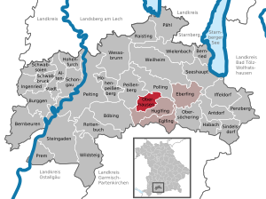
| Location of the municipality of Oberhausen in the Weilheim-Schongau district | ||
  |
||

Oberhausen is a municipality in the Upper Bavarian district of Weilheim-Schongau and a member of the Huglfing administrative community .
geography
Oberhausen is located in the Pfaffenwinkel between Murnau and Weilheim in Upper Bavaria . The Hungerbach , which rises in Huglfing, flows through the village .
Only the Oberhausen district exists .
The municipality has nine officially named municipal parts (the type of settlement is indicated in brackets ):
|
history
Until the church is planted
The place was called "Hausen unterm Wildenberg" or "Hausen bei Wildenberg" for several centuries. Oberhausen was first mentioned in a document in 950 by the district of Berg, which at that time was owned by the diocese of Brixen. On the so-called Schlossberg, southwest of Oberhausen, is the medieval Willenberg castle stables , which the nobles von Weilheim, who have lived here since around 1170 , have expanded into a hilltop castle . They called themselves the "nobles of Husen" (Hausen). The last village nobleman died in 1420. The Berg district also had its own village nobles until the 13th century; they were called the nobles of Perge. Oberhausen and Berg belonged together with Huglfing to the formerly imperial Ettal monastery of the Electorate of Bavaria .
With the community edict of 1818 , the community of Oberhausen, which belonged to the district court of Weilheim , came into being.
Incorporations
On January 1, 1978, parts of the area of the dissolved municipality of Ammerhöfe with then less than 40 inhabitants were incorporated.
Population development
Between 1988 and 2018, the community grew from 1,564 to 2,074 by 510 inhabitants or 32.6%.
| year | 1840 | 1871 | 1900 | 1925 | 1939 | 1950 | 1961 | 1970 | 1987 | 1991 | 1995 | 2000 | 2005 | 2010 | 2015 |
| population | 538 | 574 | 590 | 764 | 789 | 1279 | 1202 | 1207 | 1503 | 1739 | 1907 | 2008 | 2131 | 2103 | 2063 |
politics
Mayor is Thomas Feistl.
Municipal council
The municipal council has 14 seats. Since the 2014 local elections, the seats have been distributed as follows:
- SPD / Independent electorate: 3 seats
- Party-free electorate Oberhausen: 6 seats
- CSU / non-party members: 3 seats
- Tradition and progress: 2 seats
Architectural monuments
- Catholic Parish Church of St. Mauritius
Soil monuments
See: List of soil monuments in Oberhausen (near Peißenberg)
Economy and Infrastructure


Economy including agriculture and forestry
In 1998 there were none in the field of agriculture and forestry, 36 in the manufacturing sector and 32 in the trade and transport sector at the place of work. There were a total of 582 employees at the place of residence subject to social security contributions. There were none in the manufacturing sector and four in the construction sector.
In addition, in 1999 there were 28 farms with an agriculturally used area of 849 hectares. 30 hectares of which were arable land and 819 hectares were permanent green areas.
traffic
Oberhausen is located directly on the federal highway 472 between Schongau and Bad Tölz. The Federal Highway 2 runs a few kilometers east of the town. The next motorway junction is Sindelsdorf ( A 95 ) about 25 km to the south-east. The next train station is between Oberhausen and Huglfing. It lies on the Munich – Garmisch-Partenkirchen railway line .
education
Since 1974 Oberhausen has been part of the Huglfing school association with the villages of Huglfing and Eglfing. The pupils attend the elementary and middle school in Huglfing (middle school only since September 1, 2008).
There are the following facilities:
- Kindergartens: 50 kindergarten places with 51 children (as of 1999)
- Crèche (since September 2007)
Web links
- Entry on the coat of arms of Oberhausen (near Peißenberg) in the database of the House of Bavarian History
- Oberhausen (near Peißenberg): Official statistics of the LfStat (PDF; 1.24 MB)
Individual evidence
- ↑ "Data 2" sheet, Statistical Report A1200C 202041 Population of the municipalities, districts and administrative districts 1st quarter 2020 (population based on the 2011 census) ( help ).
- ↑ Oberhausen community (near Peißenberg) in the local database of the Bavarian State Library Online . Bayerische Staatsbibliothek, accessed on September 4, 2019.
- ↑ a b c d e municipality of Oberhausen. In: The district of Weilheim-Schongau. Published by: District Office Weilheim-Schongau 2010, texts: Max Biller (district archivist), Helmut Schmidbauer (district home administrator), page 59
- ↑ Georg Paula , Stefanie Berg-Hobohm : District Weilheim-Schongau (= Bavarian State Office for Monument Preservation [Hrsg.]: Monuments in Bavaria . Volume I.23 ). Lipp, Munich 2003, ISBN 3-87490-585-3 , pp. 182 .
- ^ Federal Statistical Office (ed.): Historical municipality directory for the Federal Republic of Germany. Name, border and key number changes in municipalities, counties and administrative districts from May 27, 1970 to December 31, 1982 . W. Kohlhammer, Stuttgart / Mainz 1983, ISBN 3-17-003263-1 , p. 595 .
- ↑ Oberhausen municipal statistics , accessed on November 6, 2010
- ↑ http://oberhausen-obb.de/Gemeinde_Oberhausen/Oberhausen_Gemeinde/Oberhausen_Gemeinderat

Cities: Penzberg | Schongau | Weilheim in Upper Bavaria
Markets: Peißenberg | Peiting
Other municipalities: Altenstadt (Upper Bavaria) | Antdorf | Bernbeuren | Bernried am Starnberger See | Böbing | Burggen | Eberfing | Eglfing | Habach | Hohenfurch | Hohenpeissenberg | Huglfing | Iffeldorf | Ingenried | Oberhausen (near Peißenberg) | Obersöchering | Pähl | Polling (near Weilheim) | Prem | Raisting | Rottenbuch | Schwabbruck | Schwabsoien | Seeshaupt | Sindelsdorf | Steingaden | Wessobrunn | Wielenbach | Wildsteig