
Raising
| coat of arms | Germany map | |
|---|---|---|

|
Coordinates: 47 ° 55 ' N , 11 ° 6' E |
|
| Basic data | ||
| State : | Bavaria | |
| Administrative region : | Upper Bavaria | |
| County : | Weilheim-Schongau | |
| Height : | 553 m above sea level NHN | |
| Area : | 21.98 km 2 | |
| Residents: | 2328 (Dec. 31, 2019) | |
| Population density : | 106 inhabitants per km 2 | |
| Postal code : | 82399 | |
| Area code : | 08807 | |
| License plate : | WM, SOG | |
| Community key : | 09 1 90 144 | |
| LOCODE : | DE RZT | |
| Community structure: | 5 parts of the community | |
| Address of the municipal administration: |
Kirchenweg 12 82399 Raisting |
|
| Website : | ||
| Mayor : | Martin Höck (neutral list of citizens) | |
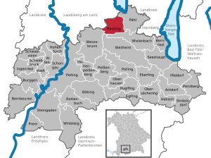
| Location of the community of Raisting in the district of Weilheim-Schongau | ||
  |
||


Raisting is a municipality in the Weilheim-Schongau district in Upper Bavaria .
The community is known nationwide through the Raisting earth station .
geography
Raisting is located in the Oberland region , five kilometers south of the Ammersee and fourteen kilometers west of the Starnberger See . The Rott , a tributary of the Ammersee, flows through the town in the west.
The municipality has five officially named municipal parts (the type of settlement is given in brackets ):
- Ertlmühle ( hamlet )
- Raisting ( parish village )
- Rothbad (hamlet)
- Sölb ( Kirchdorf )
- Stillern (hamlet)
The five places also form the five districts that exist in the municipality.
history
Until the 19th century
The place was mentioned for the first time in 776 and belonged to the Dießen monastery for a long time . It was part of the Electorate of Bavaria , but formed a closed Hofmark , the seat of which was the monastery. Together with the monastery, the Hofmark was abolished in 1803 through secularization . In the course of the administrative reforms in the Kingdom of Bavaria , today's municipality was created with the municipal edict of 1818 . Raisting initially belonged to the Landsberg am Lech district office , which the community finally had to cede to the Weilheim district office in Upper Bavaria in 1881.
Incorporations
On May 1, 1978, the district of Stillern was incorporated into the dissolved municipality of Haid as part of the municipal reform. The Pähl-Raisting administrative community that was established in the same year was dissolved on January 1, 2007.
Population development
Between 1988 and 2018 the municipality grew from 1,571 to 2,334 by 763 inhabitants or 48.6%.
| year | 1840 | 1871 | 1900 | 1925 | 1939 | 1950 | 1961 | 1970 | 1987 | 1991 | 1995 | 2000 | 2005 | 2010 | 2015 |
| Residents | 675 | 632 | 699 | 841 | 763 | 1256 | 1172 | 1304 | 1541 | 1677 | 1862 | 2071 | 2196 | 2235 | 2298 |
politics
Mayor is Martin Höck (neutral list of citizens). In 2014 he succeeded Maximilian Wagner.
Architectural monuments

Soil monuments
Economy and Infrastructure
Economy including agriculture and forestry
The municipal tax revenue amounted to the equivalent of 945,000 euros in 1999, of which the equivalent of 29,000 euros (net) was trade tax revenue.
In 1998 there were a total of 608 employees at the place of residence subject to social insurance contributions. There were no companies in the manufacturing sector and six in the construction sector. In addition, there were 63 agricultural holdings in 1999 with an agriculturally used area of 1,353 hectares. Of this, 171 hectares were arable land and 1,180 hectares were permanent green areas.
traffic

The district road WM 9 runs through the main town and leads to federal road 2 , six kilometers to the east .
The single-track Ammerseebahn from Mering via Geltendorf and Dießen to Weilheim also runs through the municipality. It is managed by Deutsche Bahn as the route book route 985. On the Ammerseebahn, between the merged districts of Raisting in the west and Sölb in the east, there is the Raisting train station , which is now just a stop . It consists of a side platform with a shelter on the continuous main track.
The Ammerseebahn was opened on June 30, 1898 by the Royal Bavarian State Railways . The Raisting train crossing station was built on it . The station building was a one-story brick building with a gable roof in the local railway style, which included counters and offices. The track systems of the station consisted of the continuous main track on a central platform , a passing track on the house platform and a loading track with goods shed connected on both sides , on which mainly agricultural products were loaded. In 1987 the station building and the goods shed were demolished, the passing track and loading track were dismantled. The train station became a stop, with a length of 12 kilometers between Dießen and Weilheim, the largest crossing distance on the Ammerseebahn.
The station has been served every hour since 2008 by trains of the Bayerische Regiobahn (BRB) from Augsburg-Oberhausen to Schongau . During rush hour , amplifier trains run every half hour between Geltendorf and Peißenberg . All trains that run on the route serve the station. Long-distance trains have not been running on the Ammerseebahn since 1991 . The state capital Munich can be reached by train in just over an hour.
education
In 1999 the following institutions existed:
- Two kindergartens with 100 places and 74 children
- A primary school with twelve teachers and 279 students
Earth station
→ Main article: Raisting earth station
The plant was put into operation in 1964. The largest antenna mirror is 25 m in diameter. The system is now operated by a development association.
Personalities
- Franz Schilcher (1660–1729), Jesuit, philosopher, Roman Catholic theologian, university professor and rector, born in Raisting
- Franz Sales Gailler (1685–1766), pastor in Raisting
- Thomas Schaidhauf (1735–1807), Rococo sculptor of the Wessobrunn School , born in Raisting
- Emil Tonutti (1909–1987), German anatomist , born in Raisting
Web links
- Entry on the Raisting coat of arms in the database of the House of Bavarian History
- Raisting: Official statistics of the LfStat (PDF; 1.24 MB)
Individual evidence
- ↑ "Data 2" sheet, Statistical Report A1200C 202041 Population of the municipalities, districts and administrative districts 1st quarter 2020 (population based on the 2011 census) ( help ).
- ^ Community Raisting in the local database of the Bavarian State Library Online . Bayerische Staatsbibliothek, accessed on September 4, 2019.
- ^ Federal Statistical Office (ed.): Historical municipality directory for the Federal Republic of Germany. Name, border and key number changes in municipalities, counties and administrative districts from May 27, 1970 to December 31, 1982 . W. Kohlhammer, Stuttgart / Mainz 1983, ISBN 3-17-003263-1 , p. 596 .
- ↑ Raisting municipal statistics , accessed on January 3, 2011
- ^ Andreas Janikowski: The Ammerseebahn. Traffic development in western Upper Bavaria . Transpress, Stuttgart 1996, ISBN 3-344-71033-8 , pp. 13-14 .
- ^ Andreas Janikowski: The Ammerseebahn. Traffic development in western Upper Bavaria . Transpress, Stuttgart 1996, ISBN 3-344-71033-8 , pp. 62-63 .
- ↑ Description of the Raisting train station ( Memento of the original from September 28, 2013 in the Internet Archive ) Info: The archive link was inserted automatically and has not yet been checked. Please check the original and archive link according to the instructions and then remove this notice. on Ammerseebahn.de
- ^ Andreas Janikowski: The Ammerseebahn. Traffic development in western Upper Bavaria . Transpress, Stuttgart 1996, ISBN 3-344-71033-8 , pp. 94 .


Cities: Penzberg | Schongau | Weilheim in Upper Bavaria
Markets: Peißenberg | Peiting
Other municipalities: Altenstadt (Upper Bavaria) | Antdorf | Bernbeuren | Bernried am Starnberger See | Böbing | Burggen | Eberfing | Eglfing | Habach | Hohenfurch | Hohenpeissenberg | Huglfing | Iffeldorf | Ingenried | Oberhausen (near Peißenberg) | Obersöchering | Pähl | Polling (near Weilheim) | Prem | Raisting | Rottenbuch | Schwabbruck | Schwabsoien | Seeshaupt | Sindelsdorf | Steingaden | Wessobrunn | Wielenbach | Wildsteig