Rothbad
|
Rothbad
Raisting municipality
Coordinates: 47 ° 55 ′ 23 " N , 11 ° 6 ′ 34" E
|
|
|---|---|
| Height : | 535 m above sea level NHN |
| Residents : | 23 (May 25 1987) |
| Postal code : | 82399 |
| Area code : | 08809 |
|
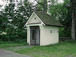
Chapel of St. Johann Nepomuk
|
|
Rothbad is a district of the Raisting municipality in the Weilheim-Schongau district in Upper Bavaria .
geography
The hamlet of Rothbad is located about one kilometer north of Raisting an der Rott .
Immediately to the north is the border with the Landsberg am Lech district , while the Ampermoos extends north-east.
history
Rothbad was not built until 1860, when a small bathing establishment with an inn was built on the Rott between Raisting and Dießen .
The bathing establishment initially consisted of two cabins and a bathing house and was located to the right of the Rott. Since the Rott regulation in the years 1919–1925, the successor buildings are on the left of the Rott.
Attractions
The St. Johann Nepomuk Memorial Chapel from 1925 is located in Rothbad.
See also: List of architectural monuments in Rothbad
Web links
- Rothbad in the location database of the Bayerische Landesbibliothek Online . Bavarian State Library
Individual evidence
- ↑ Raisting street names. Retrieved February 3, 2019 .

