
Landsberg am Lech district
| coat of arms | Germany map |
|---|---|

|

Coordinates: 48 ° 1 ' N , 10 ° 57' E |
| Basic data | |
| State : | Bavaria |
| Administrative region : | Upper Bavaria |
| Administrative headquarters : | Landsberg am Lech |
| Area : | 804.38 km 2 |
| Residents: | 120,302 (Dec. 31, 2019) |
| Population density : | 150 inhabitants per km 2 |
| License plate : | LL |
| Circle key : | 09 1 81 |
| NUTS : | DE21C |
| Circle structure: | 31 municipalities |
| Address of the district administration: |
Von-Kühlmann-Strasse 15 86899 Landsberg am Lech |
| Website : | |
| District Administrator : | Thomas Eichinger ( CSU ) |
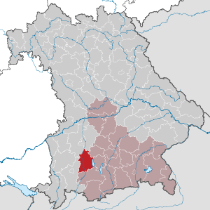
| Location of the Landsberg am Lech district in Bavaria | |
  |
|


The district of Landsberg am Lech is located in the west of the Bavarian administrative district of Upper Bavaria .
geography
location
The district is located in the west of Upper Bavaria and borders on the administrative district of Swabia . It comprises 31 municipalities with a total area of 804 km². The defining image of the district is the Lech with its numerous barrages , the Ammersee , the rural communities that extend to the foothills of the Alps and the large one at the intersection of the federal motorway 96 (Munich-Lindau) with the federal road 17 (Augsburg-Füssen-Austria) District town Landsberg am Lech. The lowest point is at 521 meters near Unterbergen, the highest at 853 meters in the Sachsenrieder forest near Dietlried .
The district has a share in the natural areas of Lechfeld , Ammersee and Pfaffenwinkel .
Land use
Settlement and traffic areas in the district take up 11.1% of the total area. The agricultural areas have a share of 80.8% of the total area of the district, of which 49.9% are agricultural areas and 28.7% are forest areas. While the north of the district is relatively poorly forested, the southern part has a high proportion of forest areas and large closed forest areas, such as the Sachsenrieder forest and the Bayerdießen forest .
Language border
The Bavarian - Alemannic language border runs through the district, essentially along the Lech . There are often clear differences in the local dialect within a few kilometers.
The Lechrain dialect is characteristic of the district .
Neighboring areas
The district borders clockwise to the north, starting with the districts of Aichach-Friedberg , Fürstenfeldbruck , Starnberg , Weilheim-Schongau , Ostallgäu and Augsburg .
history
Before 1800
First secured traces of settlement approx. 4000–1800 BC There are south of Pestenacker . Numerous burial mound fields and Celtic square entrenchments have been preserved from the Bronze Age (around 1550–1250 BC) and especially from the Hallstatt Period (700–450 BC). From 15 BC The area belonged to the Roman province of Raetia . To the west of the Lech, the Via Claudia led from Augsburg to Verona . Epfach ( Abodiacum ) was an important provincial Roman small settlement.
After the end of Roman rule took place in 5./6. Century the conquest of the Alemanni and Bavarians . In the High Middle Ages the area was ruled by the Counts of Dießen-Andechs and the Welfs , who were inherited by the Wittelsbachers in the 13th century . They founded the ducal district court of Landsberg , which extended far beyond the boundaries of today's district to the northeast ( Moorenweis , Jesenwang ) and south ( Wessobrunn , Rottenbuch ).
The district judge of Landsberg exercised high jurisdiction on behalf of the sovereign , and in numerous places also lower jurisdiction . In addition, over 30 court marks were created within the regional court , in which nobles or monasteries maintained the lower jurisdiction. The last of these patrimonial courts and court stamps were not dissolved until 1848.
Regional courts
In 1803 the regional courts were reorganized or partly rebuilt. The previous ducal district court Landsberg was converted into a Bavarian district court of the older order ; its tasks and its territory were redefined. It then included most of the places in today's district, but at that time some places in the south of the old district court were added to the district courts of Schongau and Weilheim . When the regional court in Bruck (later Fürstenfeldbruck) was set up in 1823, the regional court in Landsberg in the northeast had to hand over some communities to the new regional court.
District Office
In 1862, a new district court in Dießen am Ammersee was established from 18 communities belonging to the Landsberg regional court. Together with the Landsberg Regional Court, this formed the Landsberg District Office as an administrative authority under a Kgl. District Administrator . However, in 1879 the district court of Diessen was dissolved again. This had no effect on the district structure.
On November 1, 1874, the Landsberg district office was expanded to include the districts of Schongau.
On June 1, 1877, the city of Landsberg am Lech left the district office of Landsberg am Lech and became a city directly within the district .
On April 1, 1881, the Raisting community was ceded to the Weilheim district office in Upper Bavaria.
On January 1, 1914, the Landsberg am Lech district office handed over the Unterbergen community to the Friedberg district office. Schmiechen followed on January 1, 1915 .
district
On January 1, 1939, the designation district was introduced as everywhere else in the German Reich . So the district office became the district of Landsberg am Lech. The first district administrator was Hermann Loew (until 1942).
On April 1, 1940, the city of Landsberg am Lech was reintegrated into the district, but this was reversed on April 1, 1948.
As part of the regional reform in Bavaria , the Landsberg am Lech district was significantly enlarged on July 1, 1972. New to the district came
- the city of Landsberg am Lech , the status of a county for the loss of freedom district town received
- the communities Geltendorf and Hausen near Geltendorf in the district of Fürstenfeldbruck
- from the administrative district of Swabia the municipalities of Asch , Denklingen , Dienhausen , Ellighofen , Leeder , Oberdießen , Seestall and Unterdießen of the dissolved district of Kaufbeuren as well
- the communities of Apfeldorf , Epfach , Kinsau and Reichling of the dissolved district of Schongau .
In 2002 the spelling of the name was officially changed from "Landsberg a.Lech" to "Landsberg am Lech".
Population development
The district of Landsberg am Lech gained around 28,000 inhabitants between 1988 and 2008, or grew by around 33% - one of the strongest increases in population in Bavaria during the period mentioned. Between 1988 and 2018 the district grew from 85,629 to 120,071 by 34,442 inhabitants or by 40.2%.
The following population figures refer to the area as of May 25, 1987.
| year | 1840 | 1871 | 1900 | 1925 | 1939 | 1950 | 1961 | 1970 | 1987 | 1991 | 1995 | 2000 | 2005 | 2010 | 2015 |
| population | 28,571 | 32,287 | 36,358 | 42,788 | 45,528 | 67,220 | 64.276 | 70,313 | 83,612 | 92,623 | 99,557 | 105,939 | 112.080 | 114,626 | 117,657 |
Architectural monuments
See architectural monuments in the Landsberg am Lech district
politics
District officials and district administrators
- 1884–1900: Johann Nepomuk Streibl
...
- 1945–1958: Otto Gerbl (CSU)
- 1958–1984: Bernhard Müller-Hahl (CSU)
- 1984–2002: Erwin Filser (CSU)
- 2002–2014: Walter Eichner (CSU)
- since 2014: Thomas Eichinger (CSU)
Peter Ditsch (CSU) has been the deputy district administrator since 2002 and Ulla Kurz (SPD) since 2014.
District council
| year | CSU | Green | SPD | FW | BP | UBV | ÖDP | Lkr. Middle | FDP | AfD | The party | total | voter turnout |
|---|---|---|---|---|---|---|---|---|---|---|---|---|---|
| 2020 | 23 | 15th | 5 | 5 | 3 | 3 | 3 | n. k. | 1 | 1 | 1 | 60 | 66.0% |
| 2014 | 24 | 10 | 7th | 6th | 4th | 3 | 3 | 2 | 1 | n. k. | n. k. | 60 | 57.8% |
| 2008 | 27 | 8th | 8th | 6th | 3 | 4th | 2 | n. k. | 2 | n. k. | n. k. | 60 | 60.6% |
| 2002 | 30th | 5 | 11 | 5 | 2 | 4th | 2 | n. k. | 1 | n. k. | n. k. | 60 | 63.9% |
UBV: Independent citizens' association
District middle: district middle
n.k .: not running
coat of arms
Under a shield head roughened with white and blue , split by red and silver, a golden eagle in front, a soaring red lion behind .
Economy and Infrastructure
In the Future Atlas 2019 , the Landsberg am Lech district was ranked 44th out of 402 districts, municipal associations and independent cities in Germany, making it one of the places with "high future opportunities".
In addition to agriculture , handicrafts are an important factor in the commercial economy. Companies with supraregional importance are also located in the Landsberg district, for example Hilti in Kaufering, Hirschvogel in Denklingen, Rational AG (hot air devices), the breakdown assistance center in Southern Germany and the ADAC technology center in Landsberg am Lech , VEIT GmbH ( Worldwide leading manufacturer of ironing technology) as well as Webasto in Utting am Ammersee and Landsberg am Lech or Klausner Holz Bavaria .
The Air Force of the Armed Forces maintained until September 2017 Penzing an airbase and Landsberg the Guelph Barracks .
In December 2019, the unemployment rate in the Landsberg am Lech district was 2%.
traffic
The two junctions of the railway network in this district - Kaufering and Geltendorf - are on the Munich – Buchloe state railway, which opened in 1872/73, and which is also used by long-distance trains to Switzerland.
As early as 1872, a line led from Kaufering to the district town of Landsberg , which was further built in 1886 as the Fuchstalbahn up the Lech to Schongau . To the north, the Lechfeldbahn was built as a connection to Augsburg in 1877 .
In Geltendorf, the Ammerseebahn has crossed Augsburg - Weilheim with the east-west line Munich - Buchloe since 1898 .
From 1907 to 1929 the first cogwheel railway in Bavaria, the Kinsau cogwheel railway , ran as a works railway from the Kinsau station on the Fuchstalbahn to the wood pulp factory on the Lech.
Of the 90 km of the network, 23 km of the Landsberg – Schongau (Fuchstalbahn) line were closed for regular passenger traffic; the goods traffic on this route is operated by Augsburger Localbahn GmbH.
The federal motorway 96 , which runs in an east-west direction, connects Lake Constance with Munich. The B 17 (partly as a Romantic Road ) leads from Augsburg into the Füssen and Tyrol area .
Communities
(Residents on December 31, 2019)
Other communities
|
 
|
Municipalities of the district before the territorial reform 1971/78

Until the territorial reform in 1971/78, the Landsberg am Lech district had 59 communities (see list below). The city of Landsberg am Lech itself was an independent city .
In the west, the district bordered on the Kaufbeuren district , in the northwest on the Schwabmünchen district , in the north on the Friedberg district , in the northeast on the Fürstenfeldbruck district , in the east on the Starnberg district , in the southeast on the Weilheim district in Upper Bavaria and in the south the district of Schongau . The independent city of Landsberg am Lech was almost completely enclosed by the district.
The last changes before the territorial reform in 1971/78 were the merger of the municipalities of Oberwindach and Unterwindach to form the municipality of Windach on April 1, 1939, and the incorporation of the municipality of Sankt Georgen into the market in Dießen a.Ammersee .
The table shows the municipalities of the Landsberg am Lech district before the municipal reform in 1971/78. The churches that still exist today are shown in bold .
See also
- List of municipalities in the Landsberg am Lech district
- List of places in the Landsberg am Lech district
Protected areas
The district has 8 nature reserves , 13 landscape protection areas , eleven FFH areas and at least 17 geotopes designated by the Bavarian State Office for the Environment (as of April 2016).
See also
- List of nature reserves in the Landsberg am Lech district
- List of landscape protection areas in the Landsberg am Lech district
- List of FFH areas in the Landsberg am Lech district
- List of geotopes in the Landsberg am Lech district
License Plate
On July 1, 1956, the district was assigned the distinctive sign LL when the vehicle registration number was introduced. It is still issued today.
literature
- Bernhard Müller-Hahl (Ed.): Homeland book for the Landsberg am Lech district with the city and all communities. 2nd revised edition. District Office, Landsberg 1982 ( Between Lech and Ammersee 1, ZDB -ID 2295702-9 ).
- Bernhard Müller-Hahl (Ed.): Sagas and legends. Landsberg after 1918. Landratsamt, Landsberg 1979 ( Between Lech and Ammersee 5 (recte 6)).
- Heide Weißhaar-Kiem (conception and editing), Sonia Fischer (editor): Landsberg am Lech district. Home between Upper Bavaria and Swabia. Published by the Landsberg am Lech district. EOS, St. Ottilien 2010, ISBN 978-3-8306-7437-5 .
Web links
- Official website of the Landsberg am Lech district
- Literature from and about Landsberg am Lech in the catalog of the German National Library
- Entry on the coat of arms of the Landsberg am Lech district in the database of the House of Bavarian History
Individual evidence
- ↑ "Data 2" sheet, Statistical Report A1200C 202041 Population of the municipalities, districts and administrative districts 1st quarter 2020 (population based on the 2011 census) ( help ).
- ^ Wilhelm Volkert (ed.): Handbook of Bavarian offices, communities and courts 1799–1980 . CH Beck, Munich 1983, ISBN 3-406-09669-7 , p. 506 .
- ^ Wilhelm Volkert (ed.): Handbook of Bavarian offices, communities and courts 1799–1980 . CH Beck, Munich 1983, ISBN 3-406-09669-7 , p. 97 .
- ^ Ordinance on the reorganization of Bavaria into rural districts and independent cities of December 27, 1971
- ↑ Statistics for the district , accessed on January 21, 2011
- ↑ Future Atlas 2019. Retrieved September 25, 2019 .
- ↑ Landsberg am Lech - statistik.arbeitsagentur.de. Retrieved January 18, 2020 .
- ^ Rasch: The branch lines between Ammersee, Lech and Wertach. With the Ammerseebahn, Pfaffenwinkelbahn & Co around the Bavarian Rigi . 2011, p. 244-248 .
- ↑ "Data 2" sheet, Statistical Report A1200C 202041 Population of the municipalities, districts and administrative districts 1st quarter 2020 (population based on the 2011 census) ( help ).
- ^ Official register of places for Bavaria 1964
- ^ Michael Rademacher: German administrative history from the unification of the empire in 1871 to the reunification in 1990. Landsberg am Lech district. (Online material for the dissertation, Osnabrück 2006).
- ↑ BayernViewer of the Bavarian Surveying Administration (accessed on July 20, 2010)
Districts:
Aichach-Friedberg |
Altötting |
Amberg-Sulzbach |
Ansbach |
Aschaffenburg |
Augsburg |
Bad Kissingen |
Bad Toelz-Wolfratshausen |
Bamberg |
Bayreuth |
Berchtesgadener Land |
Cham |
Coburg |
Dachau |
Deggendorf |
Dillingen on the Danube |
Dingolfing-Landau |
Danube Ries |
Ebersberg |
Eichstätt |
Erding |
Erlangen-Höchstadt |
Forchheim |
Freising |
Freyung-Grafenau |
Fürstenfeldbruck |
Fürth |
Garmisch-Partenkirchen |
Gunzburg |
Hatred Mountains |
Yard |
Kelheim |
Kitzingen |
Kronach |
Kulmbach |
Landsberg am Lech |
Landshut |
Lichtenfels |
Lindau (Lake Constance) |
Main-Spessart |
Miesbach |
Miltenberg |
Mühldorf am Inn |
Munich |
Neuburg-Schrobenhausen |
Neumarkt in the Upper Palatinate |
Neustadt an der Aisch-Bad Windsheim |
Neustadt an der Waldnaab |
Neu-Ulm |
Nuremberg Country |
Oberallgäu |
Ostallgäu |
Passau |
Pfaffenhofen an der Ilm |
Rain |
Regensburg |
Rhön-Grabfeld |
Rosenheim |
Roth |
Rottal-Inn |
Schwandorf |
Schweinfurt |
Starnberg |
Straubing Arch |
Tirschenreuth |
Traunstein |
Unterallgäu |
Weilheim-Schongau |
Weißenburg-Gunzenhausen |
Wunsiedel in the Fichtel Mountains |
Wurzburg
Independent cities:
Amberg |
Ansbach |
Aschaffenburg |
Augsburg |
Bamberg |
Bayreuth |
Coburg |
Erlangen |
Fürth |
Hof (Saale) |
Ingolstadt |
Kaufbeuren |
Kempten (Allgäu) |
Landshut |
Memmingen |
Munich |
Nuremberg |
Passau |
Regensburg |
Rosenheim |
Schwabach |
Schweinfurt |
Straubing |
Willows in the Upper Palatinate |
Wurzburg