
Via Claudia Augusta


The Via Claudia Augusta was one of the most important Roman roads connecting northern Italy with southern Germany. In ancient times, it offered a way to cross the Alps .
course
Today's Bavaria
From the fort Submuntorium in the castle courtyards , south of Mertingen where the Schmutter in the Danube empties, was the Via Claudia Augusta with runs from west to east Roman Donausüdstraße connected. The Via Claudia Augusta followed the course of the Lech upriver via the capital of the Roman province Raetia , Augusta Vindelicorum (today Augsburg ), to Füssen .
Today's Tyrol and South Tyrol
From there she moved through the Ausserfern over the Fernpass a short distance along the Inn . From the Lower Engadine then led across the Reschenpass through the Vinschgau and the Burggrafenamt the Adige along to this via Bolzano to Trento to follow (Tridentum).
Northern Italy today
The street divided in Trento. The western strand reached the Po near Ostiglia (Hostilia) via Verona , the eastern stretch, also known as Via Claudia Augusta Altinate , reached the Adriatic Sea near Altinum via Feltre .
Intersections
A significant crossing point of this ancient road was Abodiacum , today's Epfach am Lechrain , where the east-west main line running through Raetia from Iuvavum (today Salzburg ) to Brigantium (today Bregenz ) crossed the Lech.
history
Emperor Augustus had in 15 BC Conquer the not yet conquered areas of the Alps and the northern foothills of the Alps between the Inn and the southern Black Forest by his step-sons Tiberius and Drusus as part of the Augustan Alpine campaigns .
Development of the Raetia Province
In order to develop the new province , later called Raetia , the route from Feltria / Feltre via Tridentum ( Trient ) and the Reschenpass , the Oberinntal and the Fernpass to the Lech was expanded. The road was finally completed, fully accessible for wagons, renewed and extended to the Danube under Emperor Claudius .
In the first two centuries AD, the Via Claudia Augusta was the most important connection between the Adriatic Sea and the Po Valley and the western foothills of the Alps. The road was of particular importance for the Roman imperial post . As usual, it was monitored by the beneficiaries , a traffic police made up of retired legionnaires , who were responsible for maintaining the road and ensuring the safety of its users. Over the years, a lively infrastructure developed along the street: inns and horse-changing stations ( mansiones , mutationes) were built, some of which grew into cities over the years.
With the expansion of the Via Raetia over the Brenner Pass, Teriolae / Zirl , Partanum / Partenkirchen and Urusa / Raisting , the Via Claudia Augusta lost its importance as an alpine crossing from the 2nd century, but remained a regionally important traffic route for many centuries until the Middle Ages. From the reign of Probus (276–282 AD) it was regularly maintained for about a century, but no longer as laborious as before: the beatings path through the Lermooser Moos was no longer four and a half to five meters wide, as it was before only three and had no more gravel pad. However , it is no longer recorded in the Tabula Peutingeriana , which shows the status from around 375 AD, and neither is it on Erhard Etzlaub's Romweg map from 1500. In 1430, less than ten percent of the trade was between them Augsburg and Venice via the "upper street".
Milestones, customs stations and other traces
Traces of the Via Claudia Augusta can still be found today along almost its entire route.
The famous milestone of Emperor Claudius, which was found in Rabland (Partschins near Meran) in 1552, dates from AD 46. It is the oldest Roman written monument in the Alpine region that directly refers to the construction of the Heeresstrasse. The existence of a customs post is documented on the Töll . In Hochhuebenhof in Parcines a Roman grave stone walled.
Route today at the bottom of the Forggensee
In Osterreinen in the municipality of Rieden am Forggensee example, the route runs to the base of the 1,954 pent Forggensees and is again clearly visible during the winter Abstaus. During the damming in spring, it can be seen for a short time as a dam running in the water at a water level of about 775 m above sea level.
The "Prügelstrasse" in the Ehrwald Basin
The Romans built the Via Claudia Augusta near Lermoos almost dead straight through the middle of the moor, whereby thousands of tree trunks were laid as planks floating in the moor soil. Remnants of this so-called “beatings road” preserved in the moor were discovered in the Ehrwald Basin in the 20th century .
Cities and places along the route
- Donauwörth
- Mertingen
- Meitingen
- Langweid am Lech
- Gersthofen
- augsburg
- Koenigsbrunn
- Oberottmarshausen
- Kleinaitingen
- Graben (Lechfeld)
- Landsberg am Lech
- Epfach
- Kinsau
- Hohenfurch
- Altenstadt
- Burggen
- Horseheads
- Feet
- Vils
- Pinswang
- Musau
- Pflach
- Wangle
- Lechaschau
- Yards
- Reutte
- Breitenwang
- Ehenbichl
- Heiterwang at the lake
- Bichlbach- Laehn-Wengle
- Lermoos
- Ehrwald
- Biberwier
- Fernpass
- Nassereith
- Tarrenz
- Imst
- Roasting
- Carts
- Imsterberg
- Mils at Imst
- Schönwies
- Zams
- Landeck
- Punch - grin
- Tobadill
- Flow
- Prutz
- Ried in the Upper Inn Valley
- Tossing
- Pfunds
- Nauders - Finstermünz
- Reschenpass
- Times
- Glurns
- Schlanders
- Staben (Naturns)
- Partschins , Rabland , Töll
- Algund
- Meran
- Lana
- Vilpian
- Nals
- Andrian
- Terlan
- Eppan
- Bolzano
- Laives
- Branzoll
- Except
- Neumarkt
- Kurtatsch
- Margreid
- Salurn
- Trent
- Feltre
- Altinum
bridges
Several ancient bridges have been partially or fully preserved along the trunk road:
- Susegana Bridge in Susegana (Veneto)
- Bridgehead in Algund in South Tyrol (dendrochronological investigations and radiocarbon measurements, however, speak for a construction from the 15th century)
Evidence of Roman times on the Via Claudia Augusta (picture gallery)

Gilded late Roman crested helmet, a military-historical exhibit in the Roman Museum Augsburg

The Abodiacum Museum in Epfach is particularly dedicated to the Roman era, the Via Claudia Augusta and the finds along the way
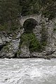
The so-called Roman bridge near Serfaus , the substance of which probably goes back to Roman antiquity, shape and construction in any case consistently correspond to the Roman bridge construction technology.


Revitalization
In the mid-1990s, the Via Claudia was rediscovered and revitalized in a cross-border touristic and cultural collaboration. The route is primarily intended for tourists interested in culture and culinary delights, some of it as a long-distance hiking trail , others also by bike.

A modern Roman statue in Epfach reminds of the old Roman traffic and trade hub with the name Abodiacum

Remains of the ancient route in the upper Inn Valley

The revitalized Via Claudia Augusta is popular for crossing the Alps by bike. Here: information board at the Fernpass

The Inn crossing at Altfinstermünz also required special attention in Roman times.

Finds by Karres on the Via Claudia Augusta in the Roman collection of the Tyrolean State Museum in Innsbruck

Roman remains of the Via Claudia Augusta in the Archaeological Museum of Trento

Via Claudia Augusta south of Augsburg on the Lechfeld near Graben


Long-distance cycle path
In the German part, the route is usually very well signposted, between Augsburg and Füssen with new signs according to ADFC and FGSV , implemented as part of the INTERREG IIIb project. In the Austrian part, too, the long-distance cycle path is largely signposted and documented. In Italy, the signs for the Via Claudia are less common.
In all countries the signs / markings are sometimes missing due to vandalism or construction work. Cyclists can use the Fernpass, the Reschenpass, between Trento and the Valsugana, from Castelnuovo in the Valsugana to the Tesino valley, over the Croce D'Aune Pass and the Praderadego Pass, with shuttle buses that can be used to transport bicycles. The Via Claudia Augusta also operates a shuttle that transports cyclists from Italy along the route back to Germany. Entry points are: Quarto D'Altino near Venice, Verona, Rovereto, Trento, San Michele all'Adige near Trento, Bozen and Merano. How to book the shuttles over the passes and the shuttle from Italy to Germany can be found on the official homepage www.viaclaudia.org of the Via Claudia Augusta project.
Mountain bike route
The Albrecht route , a mountain bike route that crosses the Alps, takes you through high mountain regions from Garmisch-Partenkirchen to Torbole on Lake Garda in seven days . She also uses some revitalized sections of the Via Claudia Augusta.
literature
- Helmut Bender: Roman road and tourist traffic. In: Ludwig Wamser (Ed.): The Romans between the Alps and the North Sea . von Zabern, Mainz 2000, ISBN 3-8053-2615-7 and ISBN 3-927806-24-2 (Landesausstellung Rosenheim 2000; series of publications by the Archäologische Staatssammlung 1), pp. 255-263 (with a photo of the gravel dam on the Via Claudia Augusta in Forggensee, p. 254; aerial photo of the road in the snow north of Lechbruck, p. 257; track at Klais in the Garmisch-Partenkirchen district with gradients of 10–12 degrees, p. 261).
- Wolfgang Czysz : Via Claudia Augusta. In: the other among others: The Romans in Bavaria. Theiss, Stuttgart 1995, ISBN 3-8062-1058-6 , pp. 528-532 (map p. 529).
- Gerold Walser : The Roman roads and milestones in Raetia . Württembergisches Landesmuseum, Stuttgart 1983 (Small writings on the knowledge of the Roman occupation history of Southwest Germany No. 29).
- Rainer Loose (Ed.): From Via Claudia Augusta to Oberen Weg. Life on the Etsch and Inn. West Tyrol and adjacent areas from prehistoric times to today. Universitätsverlag Wagner, Innsbruck 2006, ISBN 978-3-7030-0421-6 (Schlern-Schriften 334).
- Gerhard Winkler : The Roman roads and milestones in Noricum - Austria . Württembergisches Landesmuseum, Stuttgart 1985 (Small writings on the knowledge of the Roman occupation history of Southwest Germany No. 35).
Modern use
- Gianni Bodini: Via Claudia Augusta . Edition Longo, Bozen 2014, ISBN 978-88-909119-3-4 .
- Holger Nacken: Alpine cyclist: On the Via Claudia Augusta from Germany to Italy , traveldiary Reiseliteraturverlag, 2016, ISBN 978-3-944365-85-5 .
- Christoph Tschaikner: Via Claudia Augusta travel guide for car, camper, bus,… . Verlag BoD, 2014, ISBN 978-3-7357-5810-1 .
- Christoph Tschaikner: Hikeline long-distance hiking trail: Via Claudia Augusta . Esterbauer, summer 2010, ISBN 978-3-85000-510-4 .
- Christoph Tschaikner: Kompass cycling tour book Via Claudia Augusta - cycling in the footsteps of the Romans . 2009, ISBN 978-3-85026-067-1 .
- Christoph Tschaikner: Kompass cycling map Via Claudia Augusta - cycling in the footsteps of the Romans . 2009, ISBN 978-3-85026-146-3 .
- Kay Wewior: The Via Claudia Augusta Bike Travel Book . Verlag BoD, 2008, ISBN 978-3-8370-4543-7 .
- Bikeline bike tour book: Via Claudia Augusta . Esterbauer, February 2005, ISBN 3-85000-131-8 .
Web links
- http://www.viaclaudia.org/ Official website Via Claudia Augusta Bavaria - Tyrol - Italy
- http://www.roemerstrasse-via-claudia.de/ Photographic documentation of the Via Claudia between Königsbrunn and Epfach
- http://www.kaluwi.de/ViaClaudiaAugusta.html Photographic documentation between Gersthofen and Nauders
- http://www.alpen-radler.de/ Website for the book: information, map and tips on the bike path
- History-Tyrol: Via Claudia Augusta
- Via Claudia Augusta from Resia to Merano
- Via Claudia Augusta Etschradroute Vinschgau
- http://www.museum.fliess.at Museum Fliess
Individual evidence
- ↑ Rupert Gietl: The Romans on the passes of the Eastern Alps , Vienna 2004, p. 44 ( PDF )
- ^ Martin Kluger: Die Fugger in Augsburg , p. 13, ISBN 978-3-939645-63-4 . Reading sample (PDF; 1 MB)
- ^ Milestone of Emperor Claudius ( Memento from October 29, 2013 in the Internet Archive )
- ^ Roman tombstone ( Memento from October 29, 2013 in the Internet Archive )
- ↑ Via Claudia Augusta - route description section "Tirol" ( Memento from July 24, 2013 in the Internet Archive )
- ^ Department of Monument Preservation of the State of South Tyrol (ed.): Monument Preservation in South Tyrol 2008 . Tappeiner, Bozen 2009, ISBN 978-88-7073-525-3 , chapter bridge, p. 152-153 ( PDF file ).
- ↑ Martin Aschaber, Günter Guglberger, Karl Sporschill: Bridges in Tirol . Studienverlag, Innsbruck 2010, ISBN 978-3-7065-4957-8 , p. 82 .