
Carts
|
Carts
|
||
|---|---|---|
| coat of arms | Austria map | |
 |
|
|
| Basic data | ||
| Country: | Austria | |
| State : | Tyrol | |
| Political District : | Imst | |
| License plate : | IN THE | |
| Surface: | 7.5 km² | |
| Coordinates : | 47 ° 13 ' N , 10 ° 47' E | |
| Height : | 830 m above sea level A. | |
| Residents : | 620 (January 1, 2020) | |
| Population density : | 83 inhabitants per km² | |
| Postal code : | 6462 | |
| Area code : | 05412 | |
| Community code : | 7 02 06 | |
| NUTS region | AT334 | |
| Address of the municipal administration: |
No. 91 6462 Karres |
|
| Website: | ||
| politics | ||
| Mayor : | Wilhelm Schatz ( ÖVP - Karres home list ) | |
|
Municipal Council : (2016) (11 members) |
||
| Location of Karres in the Imst district | ||
  |
||
 View of Karres |
||
| Source: Municipal data from Statistics Austria | ||

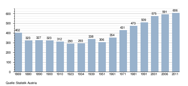
Karres is a municipality with 620 inhabitants (as of January 1, 2020) in the Imst district ( Imst judicial district ) in the state of Tyrol ( Austria ).
geography
Karres is located in the Upper Inn Valley at the foot of the Tschirgant on the sunny southern slope, near the confluence of the Pitze and the Inn . The cluster village lies on a hill above the Inn, which forms a gorge here.
Neighboring communities
Neighboring municipalities of Karres are:
- Arzl im Pitztal ,
- Haiming ,
- Roasting ,
- Roppen and
- Tarrenz
history

Archaeological excavations (Mercury statues, wall remains and foundation walls of a villa were found) prove that Karres was already settled in Roman times. However, it is assumed that settlement already took place in the late Bronze Age (1300 - 800 BC).
Since Karres was captured by Bavaria , the place was administered by the Imst court . Towards the end of the 13th century, the community came to Petersberg.
To 1099 is "Cherres" ersturkundlich occasion of the donation of a local Hube to the cathedral chapter Augsburg called. In 1288 , "Cherres" was once again named by Count Meinhard II in the Tyrolean area . Until then, the place was administered by the St. Petersberg Court. For around 12 years, Karres appears as a municipality that had its own village master (comparable to the mayor ).
In the times of the Middle Ages mining was carried out on the Tschirgant , but this had to be stopped again in the 19th century. Proof of this are two miners' houses .
In 1810 the village came back to the Imst court, but this was reversed again in 1817. In 1849 Karres was added to the newly created judicial district of Silz , but in 1907 it was transferred to the judicial district of Imst .
Population development
Culture and sights
- Parish church hl. Stephen with the surrounding cemetery and cemetery chapel
Excursion destinations
- to Karrer Alm (1613 m) and on to Tschirgant (2370 m)
- to Karröster Alm (1467 m) and on to Tschirgant (2370 m)
- is located directly on the Way of St. James in Austria
- is located directly on the Inntaler cycle path
- is on the Via Claudia Augusta
economy
The forest and meadow areas in the municipal area are mainly cultivated by part-time farmers, and gentle tourism has also established itself.
politics
coat of arms
The silver-black tip in the Karres coat of arms represents the Tschirgant, at whose foot the municipality is located. Mallets and irons refer to the mining past.
Personalities
Sons and daughters of the church
- Stephan Krismer (1777–1869), clergyman, monastery founder
Web links
- 70206 - Karres. Community data, Statistics Austria .
- Karres parish
- Karres , in the history database ofthe association "fontes historiae - sources of history"
Individual evidence
- ↑ Martin Bitschnau , Hannes Obermair : Tiroler Urkundenbuch, II. Department: The documents on the history of the Inn, Eisack and Pustertal valleys. Volume 1: By the year 1140 . Universitätsverlag Wagner, Innsbruck 2009, ISBN 978-3-7030-0469-8 , p. 243, No. 274 .
- ^ History of Karres. Michael Fritz, accessed on March 3, 2012 .
Arzl im Pitztal | Haiming | Imst | Imsterberg | Jerzens | Karres | Karrösten | Längenfeld | Mieming | Mils at Imst | Mötz | Nassereith | Obsteig | Oetz | Rietz | Roppen | St. Leonhard im Pitztal | Sautens | Silz | Sölden | Stams | Tarrenz | Umhausen | If it