Tschirgant
| Tschirgant | ||
|---|---|---|
|
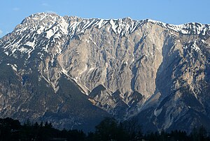
The Tschirgant from the west |
||
| height | 2370 m above sea level A. | |
| location | Tyrol , Austria | |
| Mountains | Mieming chain | |
| Dominance | 7.4 km → Bare | |
| Notch height | 1251 m ↓ wooden ladder saddle | |
| Coordinates | 47 ° 14 '31 " N , 10 ° 47' 49" E | |
|
|
||
| Normal way | from the Karröster Alm ( 1467 m ) | |
|
The Tschirgant from the south from the Ötztal. The area where the landslide fell is clearly visible. |
||
The Tschirgant is 2370 m above sea level. A. high mountain near Imst in Tyrol . The summit lies on the border of the municipalities of Karrösten and Karres . The name of this mountain is likely to be derived from its shovel-shaped tip, which retains an old dialect word for “shovel”.
location
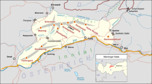
The Tschirgant is the main peak of the massif of the same name, which runs from the Tschirgant in the southwest to the 2096 m high Simmering in the northeast. It lies between the Gurgltal in the north and the Oberinntal in the south. The Tschirgant massif forms the westernmost branch of the Mieming chain .
Under the Tschirgant of 5100 m long runs Roppener tunnel of Inntalautobahn . Another tunnel through the Tschirgant massif, the Tschirgant tunnel from Haiming to Nassereith , was planned east of it.
geology
The mountain range is made up of Wetterstein limestone and dolomite and has karst forms . The mountain bar, which narrows the Inn valley to the Imster gorge , is made up of several parallel folds that sink towards the east. In the area of the White Wall there are several fault lines where a massive landslide with a volume of 240 million m³ and a deposit area of 13 km² occurred about 3000 years ago . This event was originally dated to the end of the Ice Age. Then, however, in 1987 a flood exposed tree trunks buried under the rockslide gravel, the age of which could be determined. Despite the time lag before the retreat of the Inn Glacier , the landslide is considered to be partly due to the lack of counter pressure.
The deposits of the landslide form a moraine-like hilly area between Haiming , Roppen and the mouth of the Ötztal . The agriculturally unproductive area (" Forchet ") is today a light, species-rich pine forest. Barberry, juniper and rock pear can be found in the shrub layer. The snow heather grows in the herb layer .
From the 15th century lead , silver and zinc were mined at the Tschirgant near Karrösten . A geospatial trail to the Karröster Alm leads past former tunnel entrances and spoil heaps.
Climbs
Marked alpine trails open up the popular panoramic mountain from several sides: from the south from the Karrer Alm ( 1613 m ) above Karres , from the Haiminger Alm ( 1786 m ) in the east and from the Karröster Alm ( 1467 m ) in the northwest.
literature
- Rudolf Wutscher: Mieminger chain. A guide for valleys, huts and mountains (= Alpine Club Guide . Eastern Alps. ). Written according to the guidelines of the UIAA. Bergverlag Rother, Munich 1989, ISBN 3-7633-1099-1 , p. 71.
Web links
Individual evidence
- ↑ Janua linguarum . Series maior. tape 12 . Mouton, 1964, pp. 624 .
- ↑ natural disasters. Ötztal Nature Park, accessed on February 9, 2019 .
- ↑ Karrösten: Geological trail. Geocenter Tiroler Oberland, accessed on November 14, 2018 .


